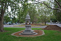
Mount Alexander Road, Melbourne
- Mount Alexander Road, Melbourne
-
Mount Alexander Road is a major road in Melbourne's inner northern suburbs.
It commences at the junction of Flemington Road and CityLink in the suburb of North Melbourne, proceeds North through Flemington forming the boundary between Flemington and Travancore, then forming the boundary between Travancore and Ascot Vale, then through Moonee Ponds and the Moonee Ponds Junction, continuing on North of the junction as a much wider roadway with a plantation separating northbound and southbound traffic.
The road then continues on through Moonee Ponds, then Essendon, before terminating at the intersection of Bulla Road, Keilor Road and Lincoln Road.
Mount Alexander Road was named as its original destination was the Gold Fields of Mount Alexander, now known as Castlemaine.
Coordinates: 37°45′41″S 144°55′17″E / 37.76139°S 144.92139°E / -37.76139; 144.92139
Categories: - Streets in Melbourne
- Melbourne geography stubs
- Australia road stubs
Wikimedia Foundation.
2010.
Look at other dictionaries:
Flemington Road, Melbourne — Infobox Australian Road road name = Flemington Road route route route photo = caption = in 2009 length = 2 direction = Southeast Northwest start = finish = est = through = Parkville route = Tullamarine Freeway Harker Street: ) exits = Flemington… … Wikipedia
Melbourne tram route 59 — City Airport West Route Information … Wikipedia
Mount Baw Baw — The view south across Gippsland from Mount Baw Baw Elevation … Wikipedia
Mount Stirling — The Bluff Spur Hut at Mount Stirling Elevation 1,749 m (5,738 ft) AHD … Wikipedia
Mount Hotham — View from the Summit Elevation 1,861 m (6,106 ft) … Wikipedia
Melbourne — This article is about the Australian metropolis. The name may also refer to the Melbourne City Centre (also known as the Central Business District or CBD ) or the City of Melbourne (the Local Government Area within which the Melbourne City Centre … Wikipedia
Mount Macedon, Victoria — For other uses, see Macedon (disambiguation). Mount Macedon Victoria Mount Macedon village from nearby Mount Towrong … Wikipedia
Melbourne and Hobson's Bay Railway Company — Main article: Railways in Melbourne The Melbourne and Hobson s Bay Railway Company was a railway company in Victoria, Australia. The company was founded on 20 January 1853 to build Australia s first railway broad gauge… … Wikipedia
Melbourne and Suburban Railway Company — Main article: Railways in Melbourne The Melbourne and Suburban Railway Company was a railway company in Victoria, Australia. The company opened a line from Princes Bridge railway station in Melbourne, Australia to Punt Road (Richmond) and South… … Wikipedia
Mount Scopus Memorial College — 200px חזק ואמץ Chazak Ve Amatz Be Strong and of Good Courage Location Burwood … Wikipedia

 Bulla Road, Niddrie, Melbourne
 CityLink /
  Flemington Road, Parkville, Melbourne
 Pascoe Vale Road
 Ascot Vale Road
 Ormond Road
