Crichel House — Farm Crichel House is a country house located near the village of Moor Crichel in Dorset, England. It is surrounded by 400 acres (1.6 km2) of parkland, which includes a crescent shaped lake covering 50 acres (200,000 m2). The original Tudor … Wikipedia
Moor — may refer to: Ethnicity Moors, several historic and modern populations from North Africa Sri Lankan Moor, a minority ethnic group of Sri Lanka Marakkar, a Muslim minority ethnic group of India Places Moor, an obsolete word for a fen or marsh, now … Wikipedia
Nathaniel Napier — For other people named Nathaniel Napier, see Nathaniel Napier (disambiguation). Sir Nathaniel Napier (died 6 September 1635), of Middlemarsh Hall and Moor Crichel in Dorset, was an English Member of Parliament (MP). He was born c.1587, the only… … Wikipedia
East Dorset — is a local government district in Dorset, England. Its council is based in Furzehill, near Wimborne Minster.The district was formed on 1 April 1974 by the merger of Wimborne Minster Urban District with part of the Ringwood and Fordingbridge Rural … Wikipedia
List of places in Dorset — This is a list of settlements and other places in Dorset, England. Settlements with a population over 3,000 are in bold. For a list of districts see the main Dorset article. See List of places in England for settlements in other… … Wikipedia
List of civil parishes in Dorset — This is a list of civil parishes in the ceremonial county of Dorset, England.BournemouthBournemouth is unparished. =Christchurch= Christchurch itself is unparished.*Burton *Hurn East Dorset*Alderholt *Chalbury *Colehill *Corfe Mullen *Cranborne… … Wikipedia
List of unions in Dorset — List of Dorset Poor Law UnionsThe Poor Law Amendment Act 1834 and its administration entailed the creation of entirely new administrative areas throughout the United Kingdom: groups of parishes known as Poor Law Unions or simply Unions .( Parish… … Wikipedia
List of sanitary districts in Dorset — Under the Public Health Acts 1873 and 1875 the Poor Law Unions were used as the basis for sanitary districts. All municipal boroughs and areas with bodies such as improvement commissioners became Urban Sanitary Districts. (Any area which acquired … Wikipedia
Humphrey Sturt — ( c. 1725 ndash; 1786) was a British architect. He designed the Horton Tower in Horton, Dorset, built 1750. He was the Lord of Horton Manor and was also the MP for Dorset 1745 1786.He was responsible for developing Crichel House at the nearby… … Wikipedia
Cranbourne Chase School — Coordinates: 51°02′17″N 2°05′38″W / 51.038°N 2.094°W / 51.038; 2.094 Cranborne Chase School for Girls was an independen … Wikipedia
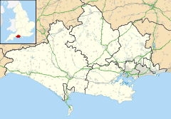
 Moor Crichel shown within Dorset
