- Nufringen
-
Nufringen 

 NufringenLocation of the town of Nufringen within Böblingen district
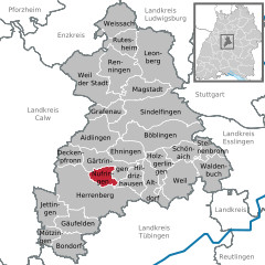

Coordinates 48°37′20″N 8°53′15″E / 48.62222°N 8.8875°ECoordinates: 48°37′20″N 8°53′15″E / 48.62222°N 8.8875°E Administration Country Germany State Baden-Württemberg Admin. region Stuttgart District Böblingen Mayor Ulrike Binninger (CDU) Basic statistics Area 10.04 km2 (3.88 sq mi) Elevation 459 m (1506 ft) Population 5,389 (31 December 2010)[1] - Density 537 /km2 (1,390 /sq mi) Founded 12th century Other information Time zone CET/CEST (UTC+1/+2) Licence plate BB Postal code 71154 Area code 07032 Website www.nufringen.de Nufringen is a municipality ("Gemeinde") in the district of Böblingen in Baden-Württemberg in Germany.
Contents
Location
Nufringen is situated in the Gäu region, 2 km (1.2 mi) of Herrenberg and 13 km (8.1 mi) of Böblingen at the Bundesstraße 14 and at the Gäubahn.
History
Nufringen was mentioned documentarily first time in the year 1182. In the 13th and 14th century the Pfalzgrafen von Tübingen have had impact on Nufringen until it was sold to Württemberg in 1382. The population was cut drastically because of the Thirty Years' War and the Black Death and did not became as big as before those events happened until the 18th century.
Nufringen belongs to the Oberamt Herrenberg since 1806. When the Gäubahn was opened, Nufringen got connection to the big transport networks. Nufringen became part of the Landkreis Böblingen because of administrative reform in 1938. In the World War II 40% of Nufringen were destroyed by an allied bombing raid. After the war Nufringen took a quick upswing.
Politics
Since the last election at the 7.6.2009 the city council ("Gemeinderat") consits of 14 members. The turnout was 60,17%. The result was:
Freie Liste Nufringen (Free list of Nufringen) 5 seats (37,20%) CDU 4 seats (28,11%) Frauenliste Nufringen (Women's list of Nufringen) 3 seats (20,90%) SPD 2 seats (13,78%) The mayor is the chairman of the Gemeinderat.
Coat of arms and flag
The coat of arms shows that the agriculture is an important part of Nufringen. Flag: Yellow-Red (Gold-Red).
Hotels and gastronomy
There is a hotel ("Lamm") and a Musikcafé in Nufringen.
Economy and infrastructure
Transport
Nufringen is situated at the today's Gäubahn Stuttgart-Singen, but just the trains of the line S1 (Kirchheim-Teck-Stuttgart-Herrenberg) of the S-Bahn Stuttgart arrive at its station.
Education institutions
With the Wiesengrundschule Nufringen has got an own Grundschule, a Hauptschule and a Werkrealschule.
Settlement Geography
If Nufringen was a town, it could be called the best example of a commuter town, because many of the working people there leave the village in the daytime and come back when it becomes evening. There are not many people who go from outside into the Industrial area in northern Nufringen, because there are not enough jobs. The only reasons for the population growth are the connection to the S-Bahn and to the autobahn. The rest of Nufringen, which consists nearly just out of residential area, circles nearly around the station. Nearly no residential area is more than 800 m (2,600 ft) away from it, so that it can be reached easily. The newest development area in southern Nufringen does it, too. There are no other public transport facilities (exepted the bus station for buses in the night. The A 81 can be reached directly by the Bundesstraße 14, which is situated next to Nufringen. The few shops are also conveniently located for cars.
Bibliography
- Roman Janssen: Nufringen: Eine Gäugemeinde im Wandel der Zeit, WEGRAhistorik-Verlag Stuttgart 1998, ISBN 3-929315-03-3
References
- ^ "Bevölkerung und Erwerbstätigkeit" (in German). Statistisches Landesamt Baden-Württemberg. 31 December 2009. http://www.statistik-bw.de/Veroeffentl/Statistische_Berichte/3126_10001.pdf.
Aidlingen | Altdorf bei Böblingen | Böblingen | Bondorf | Deckenpfronn | Ehningen | Gärtringen | Gäufelden | Grafenau | Herrenberg | Hildrizhausen | Holzgerlingen | Jettingen | Leonberg | Magstadt | Mötzingen | Nufringen | Renningen | Rutesheim | Schönaich | Sindelfingen | Steinenbronn | Waldenbuch | Weil im Schönbuch | Weil der Stadt | Weissach Categories:
- Geography articles needing translation from German Wikipedia
- Towns in Baden-Württemberg
- 12th-century establishments
- Böblingen district
- Stuttgart region geography stubs


Wikimedia Foundation. 2010.