- Ciudad Obregón
-
Ciudad Obregon — City — 
SealLocation of Ciudad Obregon in Mexico
 Ciudad Obregon
Coordinates: 27°29′21″N 109°56′06″W / 27.48917°N 109.935°W Country  Mexico
State Sonora Municipality Cajeme Founded 1927 Government - Type Ayuntamiento - Municipal President Manuel Barro Borgaro Elevation 40 m (131 ft) Population (2010) - Total 375,800 Demonym Cajemense Time zone PST (UTC-8) ZIP code 85000 - 85059 Area code(s) 644, Website http://www.obregon.gob.mx Ciudad Obregon is the second largest city in the northern Mexican state of Sonora and is situated 525 km (326 mi) south of the state's northern border with the U.S. state of Arizona. It is also the municipal seat of Cajeme municipality, located in the Yaqui Valley.
Contents
History
The city, previously named Cajeme, takes its name from Mexican Revolutionary Álvaro Obregón, a native of nearby Huatabampo, Sonora. Álvaro Obregón became president of Mexico after the Revolution and initiated an "agricultural revolution" in the Yaqui Valley, introducing modern agricultural techniques and making this valley one of the most prosperous agricultural regions in the country. Renowned U.S. agronomist Dr. Norman Borlaug, the architect of the "Green Revolution" worked here after successful developments in increasing the resistance of wheat. For his efforts he was later awarded the Nobel Prize.
Climate
Ciudad Obregon has a hot [[arid climate] with extremely hot summers and cool winters because it is located in the Sonoran desert. It is normal that in summer the temperature reach 47C, with overnight lows greater than 30 C and sometimes reaching 35°C. Sunny skies and clear nights can be expected through all the year. Many severe thunderstorms with sandstorms reach the zone in summer. Rainfall is scarce but it is more prominent it the summer. In the winter, daytime temperatures can be warmer than 30°C but at night the temperature can fall to 5°C.
Climate data for Ciudad Obregón Month Jan Feb Mar Apr May Jun Jul Aug Sep Oct Nov Dec Year Record high °C (°F) 34
(93)37
(99)41
(106)43
(109)43
(109)46
(115)46
(115)48
(118)43
(109)42
(108)40
(104)36
(97)48
(118)Average high °C (°F) 24
(75)25
(77)28
(82)31
(88)34
(93)38
(100)42
(108)42
(108)40
(104)35
(95)30
(86)25
(77)32 Average low °C (°F) 7
(45)10
(50)12
(54)17
(63)20
(68)23
(73)28
(82)28
(82)24
(75)19
(66)14
(57)8
(46)14 Record low °C (°F) −6
(21)−4
(25)−2
(28)−2
(28)4
(39)7
(45)15
(59)15
(59)8
(46)4
(39)−2
(28)−4
(25)−6
(21)Precipitation mm (inches) 23
(0.91)17
(0.67)7
(0.28)2
(0.08)2
(0.08)5
(0.2)61
(2.4)95
(3.74)60
(2.36)27
(1.06)15
(0.59)22
(0.87)340
(13.39)Source: Servicio Meteorológico Nacional[1] City origins
Cajeme Municipality has as its head Ciudad Obregón. Its first settlers established themselves in the neighborhood called Plano Oriente, as irrigation canals made by the Richardson company around 1910 and two years later, the South Pacific railroad established a station called Cajeme. The town of Cajeme was initially a part of Cocorit Municipality until its elevation to Municipal Seat on September 28, 1927. The first city government was established on January 1, 1928. The July 28, 1928 decree stated that “the city is known now with the name of Ciudad Obregón, the town formerly known as Cajeme.” In 1937 another legislation stated that Cajeme be the name of the Municipality and Ciudad Obregón its seat.
In 1950 Ciudad Obregon had a population on 120,000.[2]
Modern city
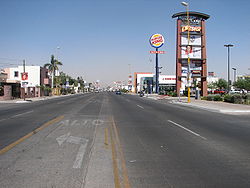 Guerrero Avenue
A lfestyle that combines traditional and modernism with the opportunities of economic growth. Located in the heart of the Yaqui Valley, Ciudad Obregón’s stands out among tourists for its modern urban design and the comforts of a medium sized city, where cultural traditions and the advantages of contemporary living mesh to create an atmosphere of well-being and productivity, of fun and security. It offers all the services for the modern tourist and business traveler; as well as the necessary infrastructure for meetings, symposia, and all types of academic and business reunions.
On foot or by car, the visitor experiences the pleasure of enjoying a city with broad, straight streets where everything is near: hotel services, restaurants that serve the freshest and most exquisite meats and sea food, shopping centers, medical services with state-of-the-art technology, university campuses, sport hunting, long nights in the city's nightspots that are packed on the weekends and above all, the hospitality of a population of 500 thousand people that are distinguished by having one of the highest education levels in the country. That's Ciudad Obregón, a young city barely 78 years old, proud of its Yaqui roots and of its immigrants that in the early 20th century came from Europe and the United States brought by the promise of a kind and fertile valley where they intermingled with the population that came from the mountains and other regions of Mexico. From these origins arises a hard-working and peaceful community that has created a wide spectrum of options to please its visitors.
Roots and traditions
The Yaqui tribe is settled in eight towns, Potam, Huirivis, Torim, Cocorit, Bacum, Vicam, Rahum and Belem. Seven kilometers from the city is the first of the eight Yaqui towns that make the autonomous territory of these people known for their independent character, because it is one of the few American ethnic groups not dominated militarily by Spanish colonialists. Yaqui history is covered with acts of heroic resistance for the defense of their territory and culture, an ancestral culture enriched by rites and traditions of which the Deer Dance stands out, a symbolic representation of the hunt for this animal whose aesthetic richness has awakened interest the world over. In the rites of Passover and Easter, or in the Day of the Dead celebration, Yaqui culture reaches its highest splendor and shows us the survival of mystery, the unity of man with the universe and the intimate relationship between people and the nature that surrounds them. One day the wind of Passover takes the Pharisees to roam the nearby cities hidden behind leather masks; another day rivalries and mundane ambitions are forgotten so that the whole tribe may join in the commemoration of its faithfully departed. Men and women that practice traditional medicine apply ancient knowledge passed on by their ancestors and with herbs and ointments cure the sickness of their relatives. Dance, music, traditional medicine and Yaqui festivities are the expression of a magical world of religion that coexists in harmony with western culture. Obregon City is also Birthplace to one of its most notorious past inhabitants: El huilito Rojas from the very first settlement in obregon city: plano oriente of Cardenas Ave. and Guerrerro.
Demographics
Ciudad Obregón is the second largest city in Sonora (after state capital Hermosillo) with a 2005 census population of 432,992 People. Its municipality of Cajeme had a population of 475,800.
As of 2005 the per capita income for the municipality of Cajeme was $10,940 and the Human Development Index was 0.8635.[3]
Government
Main article: CajemeThe position of city mayor formal equivalent in Mexico is municipal president.
Transportation
The city is served by Ciudad Obregón International Airport.
Economy
The primary economic activities in the city are agriculture, industry, cattle farming, fishing, commerce, aquaculture and turism. Agriculture is still the primary economic activity, but economic diversification is a foreseen fact.
The city development is seen in the investment that has been done in the commercial activity in the last decade.
Education
The following institutions of higher education are based in Ciudad Obregón:
- Instituto Tecnológico de Sonora (ITSON) - Campus Obregón and Campus Náinari
- Instituto Tecnológico Superior de Cajeme (ITESCA)
- Instituto Tecnológico y de Estudios Superiores de Monterrey (ITESM) - Campus Obregón
- Universidad La Salle - Campus Obregón
- Universidad TecMilenio - Campus Obregón
- Universidad Tecnológica del Sur de Sonora (UTS)
- Universidad del Valle de México Campus Ciudad Obregón (UVM)
- Universidad del Desarrollo Professional Ciudad Obregón (UNIDEP)
- Universidad Vizcaya de las Américas
- Instituto Tecnológico del Valle del Yaqui
- Universidad Durango Santander
- Universidad Interamericana de Desarrollo (UNID)
Tourism
Nainari Lagoon
 Nainari Lagoon
A peculiar tourist attraction, a product of man's whimsy is the artificial “Nainari Lagoon” with an approximate diameter of 2 kilometers located at the western city limits between Guerrero and Padre Eusebio Kino avenues. It is the ideal place for outdoor sports, and its two piers are perfect for all type of aquatic activities like skiing, sailing and canoeing being the site for triathlons, marathons, bicycle races and all manner of sports competitions. Also for everyone's delight, cold coconut stands where you can find the freshest coconuts and other fuits such as mango con chile, and restaurants. This small oasis is artificial, built in 1956, one of the great achievements of City Mayor Rene Gandara, who opened the hydraulic gates to fill the reservoir. Before it was a lagoon region where there was duck hunting and rice was grown. The Nainari Lagoon is Obregón’s bride, with its groom the trees that surround it. The Nainari Lagoon is the city's oxygen lung and tourist attraction that provides the city with a beautiful panorama, it has small boardwalk and a boat dock. On the side is the shelter for young tourists Water is constantly circulating as it is connected with the Lower Canal and entrance and exit door. The Lagoon has been in recent years better tended and remodeled by the authorities. It has at its entrance a small garden with a bronze statue of a discus thrower which gives it much enhancement. Just next to the lagoon there is a swimming called "deportivo" that is a swimming pool, and has all types of sport courts. such as tennis, basketball,etc. Its also a romantic place for couples to be at night, or just when the sun is going down. Some of the people just go to the lagoon to spend time with their friends/family.
Ostimuri Children's Park
Next to the Nainari Lagoon we have the Ostimuru Children's Park and the Ostimuri Zoo, the best place to stroll with the family, here you will find an ample variety of mechanical rides for your children. The trees that surround this place cover it with lush branches like a caress from the sky. At the park's edge the spectacular Ostimuri Zoo awaits you, an artificial habitat where a wide variety of animals exist, the song of birds as you stroll through this place is like a melody from heaven. As you make your journey in the midst of fabulous animals, you are surpassed by an imposing boa as if it were a guardian of this place.
Yaqui Museum
The museum offers a wide perspective of Yaqui culture having among its objectives rescuing, preserving, investigating and spreading the culture and way of life of the Yaquis. As well as stimulating in the state's population the rediscovery of historical, linguistic and ethnic values of the Yaquis. Another objective is to show Sonoran children and teens the particular characteristics of Yaqui personality and the richness of their folklore. Another important objective is to raise consciousness among Sonorans in regards to the development of historical events of the Yaquis as well as the important influence that they had in the formation of groups and classes that constitute the regions current society. This is made more accessible thanks to visual and interesting scenes of daily life of the population of said tribe, mounted with the instruments, tools and original clothing that has been with them since ancient times and distinguish them on and international level.
Cocorit House
This construction dates from the previous century, its architecture is of colonial style. It has four exhibition rooms and an ample garden where we find permanent samples of painting and sculptures as well as arts and crafts. Among the House's visitors is the internationally renowned sculpture and painter Jose Luis Cuevas. Among the objectives of Cocorit House is to support art in those people with artistic attributes that don't have enough support. That is why local artists call it the region's haven for the arts.
"Álvaro Obregón" Dam
Main article: Álvaro Obregón DamThe General Álvaro Obregón Dam also called the Oviachic Dam, named taken from the place it is located, starts its construction in the year 1947 and is finished in 1952, being filled first on July of the same year. It is located 32 kilometers north of Ciudad Obregón.
Lake Ouiachic has a surface of 20,500 acres (83 km2) and a storage capacity of 3226 millions of cubic meters; it forms part of the length of the Yaqui River, it's the state's largest dam and the third located on said river. From the Oviachic Dam a 2760 kilometer network of main and secondary canals is derived that irrigate 272,000 acres (1,100 km2) of surface in the Yaqui and Mayo Valleys, being one of the most important hydraulic infrastructures of the country. During the last two decades this hydraulic work has come to forma part of the main and most visited tourist destinations in our region. Thanks to its natural beauty and ample possibility to make any aquatic activity.
Huivulai Island
50 kilometers south of our city by way of 5 de Febrero street, is the Huivulai Island located 5 kilometers off the coast of the state of Sonora in the Gulf of California or the Sea of Cortez, that in Mayo language means “long neck”. Having a length of 17 kilometers and 1.2 kilometers at its widest part, the island has many natural attractions like the fine sand dunes where speed lovers can use their four wheel drive vehicles; an impressive fresh water well with a depth of 97 meters, making a paradise like oasis of date palm trees which are a sanctuary for many species of birds like the gray and white pelicans, corvetta, gray crested cranes as well as storks and albatrosses. Because it is an island it is surrounded by beautiful and tranquil beaches that invite all type of aquatic activities as well as excellent fishing of many species. also there are boat riding for all tourism. that takes you around the "Huivulai" Island.
Sports
The most popular sport in Obregon is baseball. The city's professional baseball team is named the "Yaquis de Obregon"
Their stadium is, "Estadio Tomás Oroz Gaytán"
References
- ^ Servicio Meteorológico Nacional. "Servicio Meteorológico Nacional Valores normales de 1971-2000 para Ciudad Obregón, Sonora" (in Spanish). http://smn.cna.gob.mx/. Retrieved 2008-06-08.
- ^ Columbia-Lippincott Gazeteer. (New York: Columbia University Press, 1952) p. 406
- ^ Oficina Nacional de Desarrollo Humano (2005). "IDH Municipal 2000-2005 base de datos". http://www.undp.org.mx/DesarrolloHumano/competividad/images/IDH%20municipal%202000-2005%20base%20de%20datos.xls. Retrieved 2008-12-17.
External links
- (Spanish) Office for Conventions and visitors.
- (English) Ciudad Obregón English Tourist Information Website
- (Spanish) news, pics, events in Ciudad Obregón
Coordinates: 27°29′38″N 109°56′20″W / 27.49389°N 109.93889°W
Categories:- Populated places in Sonora


Wikimedia Foundation. 2010.