- Álvaro Obregón Dam
-
Álvaro Obregón Dam
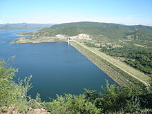
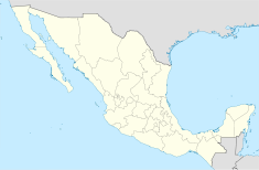
Upstream side of dam in 2006Location of Álvaro Obregón Dam Official name Presa Oviáchic Country Mexico Location Cajeme, Sonora Coordinates 27°49′21″N 109°53′34″W / 27.8225°N 109.89278°WCoordinates: 27°49′21″N 109°53′34″W / 27.8225°N 109.89278°W Status In use Construction began 1947 Opening date 1952 Dam and spillways Type of dam Embankment Height 57 m (187 ft) Length 1,457 m (4,780 ft) Impounds Yaqui River Reservoir Creates Lake Oviáchic Capacity 3,226,000,000 m3 (2,615,361 acre·ft) Surface area 208 km2 (80 sq mi) Power station Operator(s) Comisión Federal de Electricidad Commission date 28 August 1957 Turbines 2 Installed capacity 19 MW The Álvaro Obregón Dam (also known as the Oviáchic Dam) is an embankment dam on the Yaqui River north of Ciudad Obregón, in Sonora, Mexico. The purpose of the dam is water supply for irrigation, flood control and hydroelectric power production. The dam supports a power station with two generators and a 19 MW installed capacity.[1]
Background
Because of drought, the Álvaro Obregón Dam and others on the Sonora and Mayo Rivers were constructed in the 1940s and 1950s. Construction on the Álvaro Obregón Dam began in 1947 and was complete in 1952. The dam's power station was not operational until August 1957.[2] The dam is 57 m (187 ft) above the riverbed and 1,457 m (4,780 ft) long.[3] The dam has an additional saddle dam 2 km (1 mi) to its northwest and along with a system of canals, it helps irrigate 83% of a 232,999 ha (900 sq mi) area.[4] Because of drought in the 1990s and 2000s, 2004 was the first year that water from the dam's reservoir was not authorized for irrigation.[5]
See also
- List of power stations in Mexico
References
- ^ "Hidroeléctricas" (in Spanish). Comisión Federal de Electricidad. http://www.cfe.gob.mx/QuienesSomos/estadisticas/listadocentralesgeneradoras/Paginas/listadohidroelectricas.aspx. Retrieved 5 March 2011.
- ^ "The fifties drought in Sonora-- its demographic and economic effects". David Yetman. p. 3. http://docs.google.com/viewer?a=v&q=cache:68eG4SI-d2YJ:www.eci.ox.ac.uk/~dliverma/CV/Yetman%2520and%2520Liverman%2520on%25201950s%2520Sonoran%2520Drought.pdf+Ovi%C3%A1chic+Dam&hl=en&gl=us&pid=bl&srcid=ADGEESi_mn3MLpNVWI63SjTVHZIYrYXUinIEM9Ou_SHwVdldmQkoqvapKPiwxkIBLP2CkmbA4GWs-02pPx3Er70fHD-VEzShgOGvqnO6r1MYIXI8nU6nFc-NfykitaMyIRl60O7RoKSD&sig=AHIEtbQj0eRfdAPATeDEY7BD7_Ai_xkRsA. Retrieved 5 March 2011.
- ^ "Presa Alvaro Obregón" (in Spanish). Municipio de Cajeme. http://www.obregon.gob.mx/es/Cajeme/Presa/_rid/140/_mto/3/_wst/maximized?imp_act=imp_step3. Retrieved 2 June 2011.
- ^ Interciencia Asociacion, CA Salinas Zavala. "Historic development of winter-wheat yields in five irrigation districts in the Sonora desert, Mexico". http://www.redalyc.uaemex.mx/redalyc/pdf/339/33911504.pdf. Retrieved 5 March 2011.
- ^ King, Amanda (2006). Ten years with NAFTA : a review of the literature and an analysis of farmer responses in Sonora and Veracruz, Mexico. Mexico, D.F.: CIMMYT. p. 22. ISBN 9706481362. http://books.google.com/books?id=k9ya45wB-rAC&pg=PA22&lpg=PA22&dq=%C3%81lvaro+Obreg%C3%B3n+Dam+-biggest+-tallest&source=bl&ots=7NJpyQW0lG&sig=80G2caGtx_YFsSbsuzgDXbfDoU0&hl=en&ei=Ss5xTe2qDInZcbTF2fgC&sa=X&oi=book_result&ct=result&resnum=6&ved=0CDoQ6AEwBTgK#v=onepage&q&f=false.
Categories:- Dams in Mexico
- Hydroelectric power stations in Mexico
- Embankment dams
Wikimedia Foundation. 2010.


