Milton, Derbyshire

Milton, Derbyshire

Coordinates: 52°50′06″N 1°31′23″W / 52.835°N 1.523°W / 52.835; -1.523

Milton
Milton1a.JPG
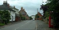
Milton's main street 2007[1].
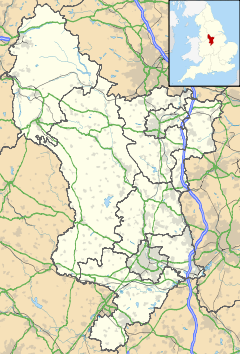
Milton is located in Derbyshire
Milton

 Milton shown within Derbyshire
OS grid reference SK322264
District South Derbyshire
Shire county Derbyshire
Region East Midlands
Country England
Sovereign state United Kingdom
Post town DERBY
Postcode district DE65
Police Derbyshire
Fire Derbyshire
Ambulance East Midlands
EU Parliament East Midlands
List of places: UK • England • Derbyshire

Milton is a Hamlet 6 miles south-west of Derby and 1.5 miles east of Repton. Its population is around 200. It is thought to have been established by the Saxons between 500 and 550 AD. It is featured in the Domesday book as Berewite of Middletune (Hamlet of Middle Farmstead). [2]

The Swan Inn is now the only pub after the Coach House reverted to a private dwelling in 2000. [3]

Nearby are Ingleby, Bretby, Foremark Reservoir and Foremarke Hall (note difference in spelling) home to Repton Preparatory School. [4]

References

  1. ^ Public domain image from Wikimedia Commons accessed May 2007
  2. ^ Milton at Derby Photos
  3. ^ Foremark.org.uk
  4. ^ Foremark Reservoir at Waterscape.com

Wikimedia Foundation. 2010.

Игры ⚽ Поможем написать реферат

Look at other dictionaries:

  • Milton — may refer to: Contents 1 People 2 Places 2.1 Australia 2.2 …   Wikipedia

  • Derbyshire — Geografie Status: Zeremonielle und Verwaltungsgrafschaft Region: East Midlands Fläche …   Deutsch Wikipedia

  • Milton Keynes (borough) — 52°02′N 0°46′W / 52.033, 0.767 …   Wikipédia en Français

  • Milton Keynes Council election, 2011 — The 2011 Milton Keynes Council election took place on 5 May 2011 to elect members of Milton Keynes Unitary Council in Buckinghamshire, England. One third of the council – the 17 seats contested in the 2007 election – was up for election and the… …   Wikipedia

  • Derbyshire — 53°8′N 1°36′W / 53.133, 1.6 …   Wikipédia en Français

  • Milton Keynes — 52.021666666667 0.73888888888888 Koordinaten: 52° 1′ N, 0° 44′ W …   Deutsch Wikipedia

  • Milton Keynes Council election, 2003 — The 2003 Milton Keynes Council election took place on 1 May 2003 to elect members of Milton Keynes Unitary Council in Buckinghamshire, England. One third of the council was up for election and the Liberal Democrats stayed in overall control of… …   Wikipedia

  • Milton Keynes Council election, 2007 — The 2007 Milton Keynes Council election took place on 3 May 2007 to elect members of Milton Keynes Unitary Council in Buckinghamshire, England. One third of the council – the seats contested in the 2003 election – was up for election and the… …   Wikipedia

  • Chapel Milton — Coordinates: 53°19′59″N 1°55′01″W / 53.333°N 1.917°W / 53.333; 1.917 …   Wikipedia

  • Comté de Milton Keynes — Milton Keynes Buckinghamshire Statut Autorité unitaire Géographie Pays …   Wikipédia en Français

Share the article and excerpts

Direct link
Do a right-click on the link above
and select “Copy Link”