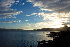
- Lake Mainit
-
Lake Mainit Lake Mainit Coordinates 9°28′N 125°31′E / 9.467°N 125.517°ECoordinates: 9°28′N 125°31′E / 9.467°N 125.517°E Lake type Oligotrophic Freshwater lake Primary inflows 28 creeks and rivers Primary outflows Calinawan River Catchment area 87,072 ha (870.72 km2) Basin countries Philippines Max. length 29.10 km (18.08 mi) Surface area 17,340 ha (173.40 km2) Average depth 128 m (419.95 ft) Max. depth 223 m (731.63 ft) Water volume 18.00 km3 (4.32 cu mi) Shore length1 62.10 km (38.59 mi) Surface elevation 42 m (137.80 ft) Settlements Mainit
Jabonga
KitcharaoReferences [1][2] 1 Shore length is not a well-defined measure. Lake Mainit is the fourth largest lake in the Philippines, having a surface area of 173.40 square kilometers.[2][3][4] The lake is also the deepest lake in the country with maximum depth reaching 223 meters.[2][5] It is located in northeastern part of Mindanao and shared between the provinces of Surigao del Norte and Agusan del Norte.
Contents
Etymology
The name of the lake is a Cebuano word "mainit", which means hot.[6]
Flora and fauna
Plants
- Fire Orchid (Vanda hookeriana)
- Narra tree (Pterocarpus indicus)
- Molave tree (Vitex parviflora)
- Philippine Rosewood or "toog"
- Kamagong
- Mancono
- Malabayabas (Eucalyptus spp.)
- Indian Lotus (Nelumbo nucifera)
Animals & Fishes
- Animals
- Mindanao Scoop Owl
- Mindanao Savannah Night Jar
- Mindanao Himalayan Swiftlets
- Mindanao Forest Kingfishers
- White-breasted Sea Eagle (Haliaeetus leucogaster)
- Monkeys
- Wild pigs
- Fishes
- "Casili" (Anguilla spp.)
- Mudfish, "hayuan" or "halwan" (Channa striata)
- Gurami (Gourami belontiidae)
- "Bolinao" (Neosthethus thessa)
List
Municipalities bordering the lake
- Mainit, Surigao del Norte
- Alegria, Surigao del Norte
- Jabonga, Agusan del Norte
- Kitcharao, Agusan del Norte
Municipalities within Lake Mainit's watershed
- Alegria[1], Surigao del Norte
- Sison, Surigao del Norte
- Tubod, Surigao del Norte
- Mainit, Surigao del Norte
- Kitcharao, Agusan del Norte
- Jabonga, Agusan del Norte
- Santiago, Agusan del Norte
- Tubay, Agusan del Norte
References
- ^ "Philippine Lakes - Lake Look to Lake Pandin". http://www.indexmundi.com/zl/rp/80.htm. Retrieved 2008-10-17.
- ^ a b c "Physical Features of Lake Mainit". Lake Mainit Development Alliance (LMDA). 2008-02-08. http://lmda.wordpress.com/category/physical-feature-of-lake/. Retrieved 2008-10-17.
- ^ "Lake Mainit". ASEAN Regional Centre for Biodiversity Conservation (ARCBC). http://www.arcbc.org.ph/wetlands/philippines/phl_lakmai.html. Retrieved 2008-10-17.
- ^ "Lake Mainit". Encyclopædia Britannica. http://www.britannica.com/EBchecked/topic/358722/Lake-Mainit. Retrieved 2008-10-17.
- ^ "Lake Mainit". BIMP-EAGA. http://www.eaga.org.bn/eaga/forestry/Philippines/Lake%20Mainit/lake%20Mainit.htm. Retrieved 2008-10-17.
- ^ "How Mainit got its name?". http://lmda.wordpress.com/category/how-mainit-got-its-name/.
Further reading
- A Directory of Philippine Wetlands. Vol I, compiled by Davies, J. et al. (Asian Wetland Bureau Philippines Foundation, Inc, 1991)
- Webpage on Lake Minit (cited part available online)
External links
- WOWSurigao.com - the City of Island Adventures, Philippines
- Lake Mainit
- Lake Mainit Updates
- Lake Mainit Development Alliance
- LMDA Updates
- Lake Mainit Online
Lakes of the Philippines Major Laguna de Bay · Lake Lanao · Taal Lake · Lake Mainit · Naujan Lake · Lake Buluan · Lake Bato · Lake Pagusi · Lake Labas · Lake LumaoMinor Lake Apo · Lake Baao · Lake Balanan · Lake Balinsasayao · Lake Bito · Lake Balukbaluk · Lake Basak · Lake Bulusan · Lake Buhi · Lake Bunot · Cabalian Lake · Lake Calibato · Lake Dagianan · Lake Danao (Albay) · Lake Danao (Cebu) · Lake Danao (Leyte) · Lake Danao (Negros) · Lake Dapao · Lake Dasay · Lake Duminagat · Lake Gunao · Lake Kalanganan · Lake Lahit · Lake Leonard · Lake Manguao · Mapanuepe Lake · Lake Maragang · Lake Maughan · Lake Muhikap · Lake Nabua · Lake Napalit · Lake Palakpakin · Lake Panamao · Lakes Pandin and Yambo · Lake Paoay · Lake Pendo · Lake Pinamaloy · Lake Pinatubo · Lake Putia · Lake Sampaloc · Lake Seit · Lake Sebu · Lake Seloton · Lake Sultan · Lake Tadlac · Lake Talao · Lake Tikub · Lake Venado · Lake Wood · Lake UyaanArtificial Ambuklao Reservoir · Binga Reservoir · Lake Caliraya · Chico Reservoir · La Mesa Reservoir · Labasin Lake · Lumot Lake · Magat Reservoir · Lake Pantabangan · Pulangi IV ReservoirCategories:- Lakes of the Philippines
- Lake Mainit
- Philippines geography stubs
Wikimedia Foundation. 2010.


