- Mairehau
-
Mairehau 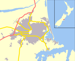
 Mairehau
Coordinates: 43°29′56″S 172°38′25″E / 43.498884°S 172.640324°ECoordinates: 43°29′56″S 172°38′25″E / 43.498884°S 172.640324°E Area - Total 0.9473 km2 (0.4 sq mi) Population (2006) - Total 2,976 - Density 3,141.6/km2 (8,136.6/sq mi) Mairehau is a suburb of Christchurch, New Zealand. It is located four kilometres north of the city centre, close to the edge of the urbanised central city area. Much new development is being carried out on the northern edge of Mairehau.
The suburb was named in 1916 after Mrs Mairehau Hutton, on account of her father Arthur Gravenor Rhodes being a major local property owner. The name Mairehau is derived from the New Zealand shrub mairehau, Phebalium nudum, named after Maire an invisible Maori mist maiden.
External links
- http://www.mairehau.school.nz/ - Official School Site
Suburbs of Christchurch City, Canterbury, New Zealand Main Suburbs Minor Suburbs Addington • Aidanfield • Avondale • Avonhead • Avonside • Balmoral Hill • Barrington • Beckenham • Bexley • Bridgend • Bromley • Brooklands • Broomfield • Burwood • Bryndwr • Casebrook • Chaneys • Clifton • Coutts Island • Cracroft • Dallington • Ferrymead • Harewood • Heathcote Valley • Hei Hei • Hillmorton • Hillsborough • Hoon Hay • Huntsbury • Hyde Park • Ilam • Islington • Kainga • Kennedys Bush • Mairehau • Marshland • Masham • Middleton • Moncks Bay • Moncks Spur • Mount Pleasant • Murray Aynsley • North Linwood • North New Brighton • Northcote • Northwood • Oaklands • Opawa • Ouruhia • Parklands • Phillipstown • Queenspark • Redcliffs • Redwood • Richmond • Richmond Hill • Richmond South • Russley • St Albans • St Andrews Hill • St Martins • Scarborough • Sockburn • Somerfield • South New Brighton • Southshore • Spencerville • Spreydon • Stewarts Gully • Strowan • Styx • Taylors Mistake • Upper Riccarton • Waimairi Beach • Wainoni • Waltham • Westlake • Westmorland • Wigram • YaldhurstCategories:- Suburbs of Christchurch
- Canterbury Region geography stubs

Wikimedia Foundation. 2010.