- New Brighton, New Zealand
-
New Brighton New Brighton Pier
 New Brighton
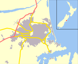
Coordinates: 43°30′23″S 172°43′52″E / 43.50636°S 172.73100°ECoordinates: 43°30′23″S 172°43′52″E / 43.50636°S 172.73100°E Area - Total 2.7891 km2 (1.1 sq mi) Population (2006) - Total 3,642 - Density 1,305.8/km2 (3,382/sq mi) New Brighton is a coastal suburb of Christchurch, New Zealand, about 8 kilometres (5.0 mi) to the east of the city centre.
Contents
Naming
The naming of New Brighton was apparently done on a 'spur of moment' decision by William Fee, an early settler of the area. When William Guise Brittan, the Waste Lands Commissioner, visited the area in December 1860, he was recognised and Fee chalked 'New Brighton' on a wooden plank, supposedly in reference to his fellow settler Stephen Brooker, who had come from New Brighton in England.[1] The Māori name for the area is Kaiuau (kai means food and aua is Yellow-eye mullet)[2] or O-ruapaeroa (an east wind blowing along the shore).[1]
The suburb is frequently referred to simply as Brighton, occasionally leading to confusion with Brighton near Dunedin.
Location
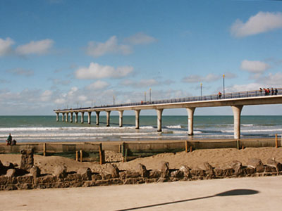
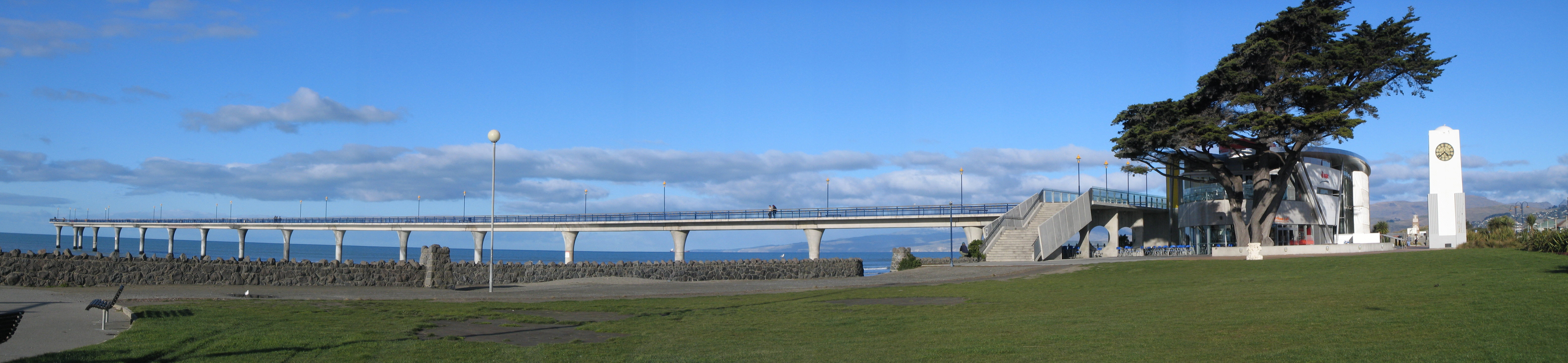
The suburb is divided into three sections spread along the southern coast of Pegasus Bay: North New Brighton; New Brighton; and South New Brighton, which lies at the northern end of a narrow peninsula between the bay and the Avon Heathcote Estuary. A 300 metres (980 ft) pier was built here in the 1990s, and opened on November 1997.
New Brighton was originally a distinct coastal village, separated from the then outer suburbs of Christchurch by the swampy areas adjoining the Avon River. However, urban expansion, land reclamation and drainage have led to Brighton being swallowed by Christchurch city.
Attractions
The current attractions of the area include:
- a sandy beach, with good surfing, stretching 18 km from the Waimakariri River mouth in the north, to the spit in the south
- swimming with (summer) surf-club-supervised areas
- birdwatching at the spit: godwits migrate from this area and their return is something of a local event
- cycling, walking, orienteering, geocaching in the extensive plantation areas which abut the northerly beach, and (of course) on the beach itself
- 4WD driving (permit required) in the extreme northern beach area
- pier and Council library on the foreshore, in Central New Brighton
- restaurants and art/craft-related shops: in growing numbers
- Home of the first surf life saving club in New Zealand established in 1910,[3] also North Beach Surf Club to the north and South New Brighton Surf Club to the south
- community market on the first Saturday of each month - held in the pedestrian part of the New Brighton Mall
- Rawhiti Domain - with a Christchurch City Council-run golf links, tnnis courts, dog park, rugby fields, cricket ovals, netball courts, community carden, archery club and children's play area
 New Brighton Pier, library, and clock tower
Saturday trading
For several decades, New Brighton had the distinction of being the only place in New Zealand where general retail shops were permitted to open on Saturdays[4] (remaining closed on Mondays), and the business district thrived as a result. With the introduction of nationwide Saturday trading in the 1980s and then seven-day trading, retail activity declined significantly.[5]
Public transport
A variety of bus routes connect the city centre with New Brighton. The Metroinfo website[6] has further information.
References
- ^ a b Harper, Margaret (July 2011). "Christchurch Place Names" (PDF). Christchurch City Libraries. pp. 131f. http://christchurchcitylibraries.com/Heritage/PlaceNames/ChristchurchPlaceNames.pdf. Retrieved 1 October 2011.
- ^ Reed, A. W. (2010). Peter Dowling. ed. Place Names of New Zealand. Rosedale, North Shore: Raupo. p. 45. ISBN 9780143204107.
- ^ "Centenary". New Brighton Surf Bathing & Life Saving Club Incorporated 1910. http://newbrightonslsc.org.nz/?page_id=16. Retrieved 1 October 2011.
- ^ "Christchurch - A Chronology - 1946". Christchurch City Libraries. http://library.christchurch.org.nz/Heritage/Chronology/Year/1946.asp. Retrieved 2007-10-14.
- ^ "East Christchurch". Te Ara Encyclopedia of New Zealand. http://www.teara.govt.nz/Places/Canterbury/CanterburyPlaces/9/en. Retrieved 2007-10-14.
- ^ http://www.metroinfo.org.nz Metroinfo website
External links
- NIWA: Pier-cam hourly image
- New Brighton Pier, circa 1915, Christchurch City Libraries
- New Brighton Surf Club
Suburbs of Christchurch City, Canterbury, New Zealand Main Suburbs Minor Suburbs Addington • Aidanfield • Avondale • Avonhead • Avonside • Balmoral Hill • Barrington • Beckenham • Bexley • Bridgend • Bromley • Brooklands • Broomfield • Burwood • Bryndwr • Casebrook • Chaneys • Clifton • Coutts Island • Cracroft • Dallington • Ferrymead • Harewood • Heathcote Valley • Hei Hei • Hillmorton • Hillsborough • Hoon Hay • Huntsbury • Hyde Park • Ilam • Islington • Kainga • Kennedys Bush • Mairehau • Marshland • Masham • Middleton • Moncks Bay • Moncks Spur • Mount Pleasant • Murray Aynsley • North Linwood • North New Brighton • Northcote • Northwood • Oaklands • Opawa • Ouruhia • Parklands • Phillipstown • Queenspark • Redcliffs • Redwood • Richmond • Richmond Hill • Richmond South • Russley • St Albans • St Andrews Hill • St Martins • Scarborough • Sockburn • Somerfield • South New Brighton • Southshore • Spencerville • Spreydon • Stewarts Gully • Strowan • Styx • Taylors Mistake • Upper Riccarton • Waimairi Beach • Wainoni • Waltham • Westlake • Westmorland • Wigram • YaldhurstCategories:- Suburbs of Christchurch
- Surfing locations in New Zealand

Wikimedia Foundation. 2010.