- Oxie
-
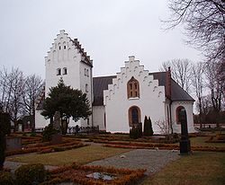
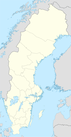
Oxie Oxie church, 12th century Coordinates: 55°33′N 13°06′E / 55.55°N 13.1°ECoordinates: 55°33′N 13°06′E / 55.55°N 13.1°E Country Sweden Province Skåne County Skåne County Municipality Malmö Municipality Area[1] - Total 3.25 km2 (1.3 sq mi) Population (2005-12-31)[1] - Total 9,225 - Density 2,841/km2 (7,358.2/sq mi) Time zone CET (UTC+1) - Summer (DST) CEST (UTC+2) Oxie is a locality and a city district in Malmö Municipality, Skåne County, Sweden with 9,225 inhabitants in 2005.[1]
Notable buildings include the medieval Oxie church, (Oxie kyrka) and the water tower. From the train station commuter trains proceed to Malmö and Ystad.
It is dominated by residential areas of detached and semi-detached houses. Oxie centrum is the center point of the town with a small square, several stores, service providers and the seat of the local ward administration (Stadsdelsförvaltningen).
Contents
History
The area around Oxie is rich in archaeological finds. Settlements from the neolithic, bronze age and iron age have been discovered. The spectacular bronze-age burial mounds Kungshögarna (Mounds of the Kings) provides a monumental sight, overlooking the highway to Malmö. These mounds, at 60 m above sea level, are also the highest natural point in Malmö municipality.
Oxie is first mentioned in written sources 1130 as Oshögha, believed to mean the mound by the spring. As the center point of the church municipality Oxie hundred, Oxie was also the seat of the hundred thing (Häradstinget), which was held every spring and autumn. Local names such as Tingbacken (Thing hill) and Tingdammen (Thing pond) indicate the location of the things. Galjebacken (Gallow Hill) is another place, bearing witness to the judicial powers of the hundred thing. Galjebacken was used for executions well into the 19th century. The oldest building in Oxie is the church, originally built in 1160. It was heavily restored in 1848 by Carl Georg Brunius, but the walls of the nave, the southern gate and the Baptismal font are all remains from the original church. There are theories that a wooden church existed at the site prior to the 1160 stone construction.
In the late 19th and early 20th century the village expanded with the establishment of several brick and gravel industries. Remains from this era can still be seen in the topography of Oxie. For example, the ponds Kvistadammarna, are the remaining digs from where Djurbergs brick factory extracted clay. Like in many other small, rural communities this rapid industrialisation was facilitated by the establishment of railroad communications.
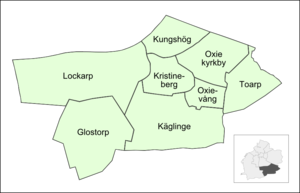
Oxie was a municipality of its own until it merged with Malmö in 1972. Today Oxie is made up of the previously separate villages Oxie, Käglinge, Toarp and Kristineberg. In addition, Oxie ward also includes the villages Lockarp sv:Lockarp, Glostorp and Krumby.
Neighbourhoods
Glostorp • Kristineberg • Kungshög • Käglinge • Lockarp • Oxie kyrkby • Oxievång • Toarp
Demographics
During the later half of the 20th century, the population exploded to more than 10 000, from 1 608 in 1957, as it became more attractive for families to move outside of the city. A major residential area, Oxievång, was built during the 1970–1980s.
During the 1990s and early 21st century, significant numbers of immigrants have moved to Oxie. The ten most common countries of birth except Sweden:
 Denmark (858)
 Poland (220)
 Former Yugoslavia (200)
 Iraq (108)
 Hungary (95)
 Iran (91)
 Pakistan (84)
 Germany (78)
 Bosnia and Herzegovina (77)
 Finland (66)
The construction of the Öresund bridge, combined with the high cost of living in Denmark, has led to large numbers of Danish people settling in Oxie recently. The proximity to Copenhagen and good communications make Oxie an attractive alternative for those who commute to the Danish side. In 2006 there were 451 Danish-born persons; in 2007 this figure had increased to 602 and in 2009 858 Danes lived in Oxie.
Education
There are nine public preschools/kindergartens as well as four schools in Oxie today. Blankebäcksskolan, Kungshögsskolan and Tingdammsskolan are primary schools, while Oxievångsskolan is a secondary school. Oxie is the location of Ingvar Strandh's Flower school (Blomsterskola). It is the leading florist school in Sweden, with students coming from as far as Japan to participate in courses.
Flower Capital
Oxie is the number one flower transit point in Sweden. Several flower importing companies have facilities in Oxie, receiving shipments of flowers from all over Europe. As much as 80% of the imported cut flowers coming to Sweden pass through here. This as well as Ingvar Strandh's blomsterskola makes Oxie something of the Flower capital of Sweden.
References
- ^ a b c "Tätorternas landareal, folkmängd och invånare per km2 2000 och 2005" (in Swedish) (xls). Statistics Sweden. http://www.scb.se/statistik/MI/MI0810/2005A01B/T%c3%a4torternami0810tab1.xls. Retrieved 2009-05-10.
Districts and neighbourhoods of Malmö Municipality Centrum Davidshall • Ellstorp • Frihamnen • Gamla staden • Inre hamnen • Katrinelund • Lugnet • Malmöhus • Mellersta hamnen • Norra hamnen • Oljehamnen • Rådmansvången • Rörsjöstaden • Slussen • Sorgenfri industriområde • Spillepengen • Värnhem • Västra hamnen • Västra Sorgenfri • Östervärn • Östra hamnen
Fosie Husie Almgården • Elisedal • Fortuna Hemgården • Höja • Jägersro • Jägersro villastad • Kvarnby • Riseberga • Stenkällan • Södra Sallerup • Toftanäs • Videdal • Virentofta • Östra SkrävlingeHyllie Bellevuegården • Borgmästaregården • Gröndal • Holma • Hyllievång • Kroksbäck • Kroksbäcksparken • Kulladal • Lindeborg • Lorensborg • Stadion • Svågertorp • Södertorp • ÄrtholmenKirseberg Bulltofta • Håkanstorp • Johanneslust • Kirsebergsstaden • Rostorp • Sege industriområde • Segemölla • Segevång • ValdemarsroLimhamn-Bunkeflo Annetorp • Bellevue • Bunkeflostrand • Djupadal • Elinelund • Gamla Limhamn • Hyllieby • Kalkbrottet • Klagshamn • Limhamns hamnområde • Naffentorp • Nya Bellevue • Rosenvång • Sibbarp • Skumparp • Tygelsjö by • Tygelsjö vång • Vintrie • Västra KlagstorpOxie Rosengård Apelgården • Emilstorp • Herrgården • Kryddgården • Persborg • Rosengård Centrum • Törnrosen • Västra Kattarp • Örtagården • Östra KyrkogårdenSödra Innerstaden Allmänna sjukhuset • Annelund • Flensburg • Lönngården • Möllevången • Norra Sofielund • Sofielunds industriområde • Södervärn • Södra Sofielund • Västra Sorgenfri • Östra SorgenfriVästra Innerstaden Dammfri • Fridhem • Fågelbacken • Hästhagen • Kronborg • Kronprinsen • Mellanheden • Pildammsparken • Ribersborg • Ribersborgsstranden • Rönneholm • Solbacken • Teatern • VästervångMalmö Municipality • Malmö Urban Area • Metropolitan Malmö • Burlöv Municipality (Arlöv) Localities in Malmö Municipality, Skåne County, Sweden Localities: Bunkeflostrand · Kristineberg · Malmö (part of) (seat) · Oxie · Södra Klagshamn · Tygelsjö · Västra Klagstorp · VintrieCategories:- Populated places in Skåne County
- Boroughs of Malmö
Wikimedia Foundation. 2010.


