- Monroe Township, Ashtabula County, Ohio
-
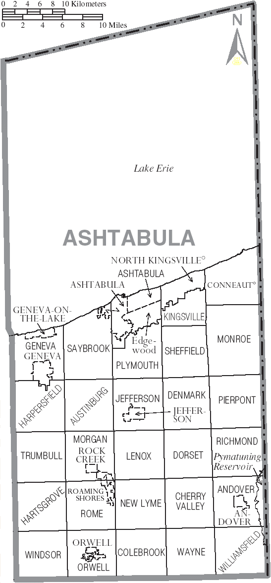
Monroe Township, Ohio — Township — Municipalities and townships of Ashtabula County.
Coordinates: 41°51′5″N 80°34′53″W / 41.85139°N 80.58139°WCoordinates: 41°51′5″N 80°34′53″W / 41.85139°N 80.58139°W Country United States State Ohio County Ashtabula Area – Total 38.6 sq mi (100.0 km2) – Land 38.6 sq mi (99.9 km2) – Water 0.0 sq mi (0.1 km2) Elevation[1] 919 ft (280 m) Population (2000) – Total 2,268 – Density 58.8/sq mi (22.7/km2) Time zone Eastern (EST) (UTC-5) – Summer (DST) EDT (UTC-4) FIPS code 39-51296[2] GNIS feature ID 1085732[1] Monroe Township is one of the twenty-seven townships of Ashtabula County, Ohio, United States. The 2000 census found 2,268 people in the township.[3]
Contents
Geography
Located on the northeastern edge of the county, it borders the following townships and city:
- Conneaut - north
- Conneaut Township, Erie County, Pennsylvania - northeast
- Beaver Township, Crawford County, Pennsylvania - southeast
- Pierpont Township - south
- Denmark Township - southwest corner
- Sheffield Township - west
- Kingsville Township - northwest
No municipalities are located in Monroe Township.
Name and history
It is one of twenty-two Monroe Townships statewide.[4]
The first settler in Monroe Township was Stephen Moulton, who arrived from New York in 1799.[5]
Government
The township is governed by a three-member board of trustees, who are elected in November of odd-numbered years to a four-year term beginning on the following January 1. Two are elected in the year after the presidential election and one is elected in the year before it. There is also an elected township fiscal officer,[6] who serves a four-year term beginning on April 1 of the year after the election, which is held in November of the year before the presidential election. Vacancies in the fiscal officership or on the board of trustees are filled by the remaining trustees. Currently, the members of the board are John Griggs, Harry Osburn, and Charles Riley.[5]
References
- ^ a b "US Board on Geographic Names". United States Geological Survey. 2007-10-25. http://geonames.usgs.gov. Retrieved 2008-01-31.
- ^ "American FactFinder". United States Census Bureau. http://factfinder.census.gov. Retrieved 2008-01-31.
- ^ Ashtabula County, Ohio — Population by Places Estimates Ohio State University, 2007. Accessed 15 May 2007.
- ^ "Detailed map of Ohio" (PDF). United States Census Bureau. 2000. http://www2.census.gov/geo/maps/general_ref/cousub_outline/cen2k_pgsz/oh_cosub.pdf. Retrieved 2007-02-16.
- ^ a b Ashtabula County, Ohio Ashtabula County, 2007. Accessed 2007-05-28.
- ^ §503.24, §505.01, and §507.01 of the Ohio Revised Code. Accessed 4/30/2009.
External links
Municipalities and communities of Ashtabula County, Ohio Cities 
Villages Townships Andover | Ashtabula | Austinburg | Cherry Valley | Colebrook | Denmark | Dorset | Geneva | Harpersfield | Hartsgrove | Jefferson | Kingsville | Lenox | Monroe | Morgan | New Lyme | Orwell | Pierpont | Plymouth | Richmond | Rome | Saybrook | Sheffield | Trumbull | Wayne | Williamsfield | Windsor
CDP Unincorporated
communitiesAustinburg | Dorset | Footville | Kingsville | Pierpont | Unionville | Williamsfield | Windsor
Categories:- Townships in Ashtabula County, Ohio

Wikimedia Foundation. 2010.