- Cheeks Hill
-
Cheeks Hill 
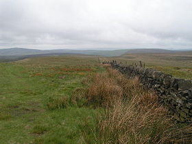
Cheeks Hill summit from the Staffordshire sideElevation 520 m (1,706 ft) [1] Location Location Staffordshire, Derbyshire Coordinates 53°13′31″N 1°57′44″W / 53.2252°N 1.9621°WCoordinates: 53°13′31″N 1°57′44″W / 53.2252°N 1.9621°W OS grid SK0269 Cheeks hill is a hill near Buxton and the border between Derbyshire and Staffordshire. It is the highest point in Staffordshire and is 520 metres (1,710 ft) high. It is part of the Axe Edge Moor and lies close to the Cat and Fiddle Road.
Profile
At the summit there is a drystone Wall Marking the border between Staffordshire and Derbyshire, on the Staffordshire side there is a Disused Quarry and Shaft, On the Derbyshire side is Dane head which is the start of the River Dane, nearby is 3 shires head and Cheeks hill is the most northern point in Staffordshire.
References
Categories:- Staffordshire geography stubs
- Hills of Staffordshire
Wikimedia Foundation. 2010.
