- Neighborhoods of Hartford, Connecticut
-
The Neighborhoods of Hartford, Connecticut are varied and historic.
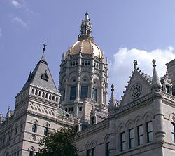 The Connecticut State Capitol in downtown Hartford
Central Business District/Downtown
Main article: Downtown HartfordDowntown is Hartford's primary business district. It is the location of the city government offices as well as the State Capitol.
Parkville
Parkville takes its name from its location at the junction of the North and South Branches of the Park River.
The area, similar to others surrounding Hartford, was primarily farmland through much of the 19th century. In 1878, residents tried to secede from Hartford, claiming they were over-taxed merely because their land was not developed. By the early 1880s, the expansion of the adjacent Frog Hollow neighborhood, coupled with the extension of the railroad line southwest towards New Haven, forever changed the complexion of Frog Hollow.
In 1907, Royal Typewriter was built along the railroad tracks and other factories moved into the neighborhood, stimulating the need for housing for workers. The early population of the neighborhood was Irish, followed by French Canadian, Scandinavian and German. Today, the neighborhood has a large population of Portuguese, Brazilians, Vietnamese, and Puerto Ricans.
Frog Hollow
Frog Hollow takes its name from the marshy conditions in the low land near what is now the corner of Broad and Ward Streets. The neighborhood was originally developed as three- and six-family buildings to house the immigrant population who worked in the factories which lined Capitol Avenue. The Park River, now underground, once was used as a source of water power by the factories. An inlet of the Park River Tunnel lies near Pope Park, providing an entry point for tunnel explorations by urban speleologists.
Lafayette is the neighborhood's oldest street, appearing on a 1640 map of Hartford as part of the "Road from George Steele's to the Great Swamp." It was called Cooper Lane between 1838 and 1851 and was home to the pre-Civil War African-American community in Hartford.
Park Street was once called Malt Lane. In 1821, it was renamed for Barnard Park at its eastern end, which was the only park in the city at the time. Park Street has also been called "New England's Spanish Main Street" because of the predominantly Puerto Rican population and merchants. Currently Park Street is under major construction. Cobblestone sidewalks are being made, as well as more parking for consumers and repaved streets.
The neighborhood is home to Pope Park, designed by renowned Olmsted Brothers landscape architects. Land for the park was donated by industrialist Albert Pope, who believed that the success of any business was in large part reliant upon the happiness of its employees. Today, the 75-acre (300,000 m2) park provides recreational facilities for neighborhood families.
 Mural near Trinity College
The Frog Hollow neighborhood is now home to an array of Spanish merchants. Once inhabited by French merchants, the migrating trend after WWII brought migrants from Puerto Rico. Throughout the years ethnic groups calling the area home have been diverse, and have included Swedish, Danish, German, Irish, French Canadian, Greek and Puerto Rican.
Frog Hollow now attracts consumers who are looking for Caribbean food and products. Hartford Mayor Eddie Perez hopes to attract new merchants looking to expand their businesses into Hartford. Also under works is the opening of Park Street which will feature a plaza modeled after Plaza Mayor in Madrid, Spain, at the intersection of Park Street and Main Street.
Frog Hollow has a relatively low rate of home ownership but with careful city planning, this is being changed at a dramatic rate. Frog Hollow is also home to Hartford Superior Court, Hartford Public High School, Hartford Community Court, Family Court, Trinity College, The Learning Corridor, The Lyceum Resource and Conference Center, and Broad Street Juvenile Court. Hartford Public High School, more notably is considered the nation's second oldest high school in existence.
Asylum Hill
 Asylum Hill
The Asylum Hill neighborhood was originally known as "Lords Hill." The Asylum Hill neighborhood is home to the Asylum Hill Congregational Church (organized in 1864), The Trinity Episcopal Church, and Saint Joseph's Cathedral (dedicated 1892).
Many insurance companies have been located in the Asylum Hill neighborhood, such as The Hartford and Rossia Insurance Company (now Northeastern Insurance Company). Aetna Insurance Company still remains as a major fixture along Farmington Avenue and recently announced that they will be moving more than 3,400 of their Middletown, Connecticut employees to Hartford. Also along Farmington Avenue are the homes of Mark Twain and Harriet Beecher Stowe, which are now museums.
 Mark Twain House
In March 2006, the Connecticut Culinary Institute, which was recently renamed the Lincoln Culinary Institute, opened a branch in the former Hastings Hotel and Conference Center next to the world headquarters of Aetna.[1] The Hastings was primarily a business hotel that housed former President Bill Clinton when he visited the city. The hotel closed abruptly in 2004. Trinity College in Hartford has also housed students at the former Hastings Hotel due to an extremely large freshman class.
West End
The West End neighborhood, which runs from the Park River, just past the Mark Twain House to the West Hartford border, was mostly farmland until 1870. During the 1900s-1920s many two and three story homes were built, lending a residential, Victorian air to the neighborhood which persists to this day.
Elizabeth Park [1] in the West End was created in 1895, when Charles N. Pond gave his estate to the Hartford Parks Commission which created the park and named it in honor of his wife. The park boasts a playground, softball field, and other recreational facilities in addition to views of the downtown skyline. It features the oldest, and one of the largest, municipal rose gardens in the United States. Elizabeth Park's famous rose arches were designed by noted rosarian Theodore Wirth in 1904.
The University of Connecticut School of Law, Watkinson School and the Hartford Seminary are located in the West End. Prospect Avenue boasts belle epoque and jazz age mansions, including the Governor's Mansion. Grand estates also line Scarborough Street including the former residence of A. Everett 'Chick' Austin (Director of Wadsworth Atheneum from 1927 to 1944).
The southern West End and Parkville also serve as the local Gay Village.
Sheldon/Charter Oak
The neighborhood is located just south of downtown with the Connecticut River and I-91 running at the eastern end of the neighborhood. The Charter Oak monument is located at the corner of Charter Oak Place, a historic street, and Charter Oak Avenue.
The area was home to the Colts Firearm Factory which was started by Samuel Colt, who invented the revolver. Along with building a factory, Mr. Colt also made a village with houses, a library, and recreational activities so that his employees could be close to work. Colt's estate, Armsmear, was given to the city as Colt's Park after Mr. and Mrs. Colt's death. A developer is currently in the process of renovating the whole facility to create office space and apartments for completion in 2006/2007.
The Capewell Horsenail Company was also in the area. In 1881, George Capewell invented a machine to make horseshoe nails.
The Sheldon Oak neighborhood is now home to a division of Clear Channel Radio and is currently under construction. Sheldon/ Charter Oak is under a major renovation with new city housing as part of Mayor Perez's plan to improve city life for residents and improve Hartford's image.
-

Norwich Street - new construction
Clay-Arsenal and Upper Albany
Once home to a mostly Irish and Jewish population, Upper Albany and Clay-Arsenal today are primarily African American, West Indian/Caribbean and Latino. Following World War II, a series of events occurred that led to a sharp decline. This began with the construction of Interstate 84 which gutted the neighborhood, separating it from nearby downtown. During this time the city's once strong manufacturing base dissolved, creating the start of a mass exodus to ringing suburbs (most notably north to neighboring Bloomfield and Windsor). Former military barracks were converted into housing projects, creating a high concentration of low-income housing. But perhaps the most devastating blow occurred on April 4, 1968: Following the assassination of Dr. Martin Luther King Jr., a riot ensued that resulted in massive arson, particularly on Albany Avenue. Within a few hours, the North End's major commercial strip was simply gone, and the remaining white population fled, and much of the middle and working class black population left in the following years.
Today the Upper Albany and Clay-Arsenal are home to an active community of West Indian/Caribbean immigrants that provide the area with a cultural and artistic presence: the West Indian Social Club and Scott's Jamaican Bakery are two notable neighborhood institutions. In an effort to increase home ownership in distressed parts of the neighborhood, some real estate companies have begun to call the Upper Albany and Clay-Arsenal areas as 'Uptown', after Manhattan's well known Harlem neighborhood. The Hartford Housing Authority has razed the Stowe Village projects on Kensington Street and built single family townhouses in its place. Habitat for Humanity and other community organizations have built several homes throughout the neighborhood and the rest of the city.
In spite of these neighborhoods' overwhelmingly negative reputation for its crime, distressed economic state, and dilapidated appearance, there are some positive recent developments. There are isolated pockets of renewal, such as the revitalization of Belden Street (seen below in the gallery).
-

North End Decay
-

Abandoned house on Albany Avenue, North End
-

Belden Street revitalization
-

Bellevue St. revitalization
South End and Little Italy
Maple Avenue, Wethersfield Avenue and Franklin Avenue are the three major roads in the South End, adjacent to the Hartford-Wethersfield town line in the southern part of the city. Franklin Avenue is known as the city's Little Italy. Although many Italians have moved just over the border to Wethersfield, Newington, and Rocky Hill, there is still a major Italian presence in that portion of the city. Eric Mangini, the former Head Coach of the New York Jets and now the Cleveland Browns grew up on Franklin Avenue.
There are numerous Italian bakeries and merchants along Franklin Avenue. In the past few decades,[when?] there has been white flight from the South End, with many Puerto Rican families moving into the neighborhood but nevertheless there are many local favorites (restaurants, bakeries and stores) that draw people back into the South End.
The area's Italian population came out in full force when Italy won the FIFA World Cup in 2006 with thousands marching and driving down Franklin Avenue for hours with Italian flags raised high. In recent years[when?] many eastern European ethnic groups have moved into South End neighborhoods, predominantly Bosnians, Albanians and other ethnic groups from the former Republic of Yugoslavia.
The Hartford portion of 237-acre (0.96 km2) Goodwin Park (85 acres of which are in the town of Wethersfield) is in the South End.[2]
South Green
South Green is home to Barnard Park in honor of Henry Barnard, whose home is located on Main Street. Congress Street and Morris Street compose a historic district with many Greek Revival and Italianate homes. Previously it was rumored that many of the homes in this area were slated for demolition in the early 1980s as many were boarded up. Today, Congress Street is a well-kept street complete with cobblestone crosswalks and architecturally harmonious lighting.
Hartford Hospital, the largest hospital in the area, and the adjacent Connecticut Children's Medical Center, which is the only hospital primarily for children, are also located in South Green.
-

Biltmore Commons condominiums
-

The Maple Avenue Mews condominiums
Barry Square
South of the South Green neighborhood is Barry Square, named for Father Michael Barry, Roman Catholic priest of St. Augustine's Church on Campfield Avenue, built in 1902. Trinity College's campus is in this neighborhood.[3]
South Meadows
Located at the southeastern corner of the city, the area is home to many industrial and commercial businesses. The neighborhood is home to the Regional Market, a 32 acre (129,000 m²) facility with 185,000 of warehouse space. Brainard Field along I-91 serves small aircraft and offers flight instruction. The Hartford Electric Light Company which started in 1921 is still operational and owned by CT Light and Power. One of the Metropolitan District Water pollution control plants is located in the south meadows. Also, the Mid-Connecticut Resource Recovery Facility, which opened in 1987 and is on 57 acres (231,000 m²), is located in the area.
Southwest
Southwest is a predominantly residential neighborhood at the southwestern corner of the city, adjoining the towns of Wethersfield, Newington and West Hartford. Cedar Hill Cemetery, which was designed by landscape architect Jacob Weidenmann is located in Southwest.[4]
Behind the Rocks
Behind the Rocks is a predominantly residential neighborhood at the southwestern corner of Hartford below Parkville, bordering the town of West Hartford.
North Meadows
Located just north of downtown along the CT River and I-91 the North Meadows is a largely commercial and industrial area that is home to many of the area's car dealerships including dealers for Mercedes-Benz, BMW, Nissan, Infiniti, Jaguar, Toyota and Mazda as well as a brand new CarMax dealership. The North Meadows is also the home of the CT Expo Center which features 88,000 square feet (8,200 m2) of exhibition space, the Meadows Music Theater (formerly the Dodge Music Center), which hosts dozens of big name concerts each year, and Riverside Park. Also in the North Meadows are some of Hartford's "adult" attractions: Multiple shops specializing in pornography and other sexual novelties and a strip club are visible from I-91 north of the I-84 interchange.
The CT DOT operates regional CT Transit buses out of the North Meadows, near Riverside Park. Riverside Park is part of Riverfront Recapture, a project undertaken by the State of Connecticut and the City of Hartford, aiming to renew interest in the waterfront of the Connecticut River. Included in the park are a high ropes challenge course, a playground, boat launch, and the Riverfront Recapture boathouse, home to numerous private clubs and the crew teams for numerous regional schools, including Watkinson School, East Hartford and Hartford public schools.
Blue Hills
Main article: Blue Hills, ConnecticutThe northwest corner of the city, known as Blue Hills, is home to many schools and homes. It has roughly 10,000 residents, and has several schools and one university located there. Its main thoroughfares are Granby Street, Blue Hills Avenue (Route 187), Plainfield Street, Bloomfield Avenue (Route 189) and Albany Avenue (Route 44). Connecticut Transit operates several bus routes through the neighborhood, such as the 50 and 52, which run on Blue Hills Avenue, the 56 and 58, which run up on Albany Avenue and Bloomfield Avenue, the 74, which runs through Westbrook Village on its way to Copaco Shopping Center via Granby Street, and the 76, which runs on Cornwall Street towards Bowles Park. Blue Hills has a majority of West Indian and African American people living there. Education wise Annie Fisher School, Mountain Laurel School (Annie Fisher School Annex), Rawson School, Mark Twain School, Weaver High School, Watkinson School, and the University of Hartford.
Northeast
The Northeast neighborhood (sometimes known as North End) is the portion of Hartford east of Blue Hills and west of the Amtrak railroad tracks. It is home to the 1944 Hartford Circus Fire Memorial, Keney Park, which is the largest municipal park in New England and Weaver High School, which was also the alma mater of ER actor Eriq La Salle.
References
- ^ "CT Culinary Institute - About Us". http://ctculinary.com/aboutus/index.php. Retrieved 2010-03-31.
- ^ Karen O'Maxfield, South End, Neighborhoods of Hartford website, accessed October 9, 2009
- ^ Karen O'Maxfield, Barry Square, Neighborhoods of Hartford website, accessed October 9, 2009
- ^ Karen O'Maxfield, South West, Neighborhoods of Hartford website, accessed October 9, 2009
External links
- Hartford Neighborhood Data, Hartford Public Library website
- Neighborhoods of Hartford (maps, photos, and descriptions)
Categories:- Geography of Hartford, Connecticut
- Neighborhoods in Connecticut
-


Wikimedia Foundation. 2010.