- Dhahran International Airport
-
Dhahran International Airport 
IATA: DHA – ICAO: OEDR Summary Airport type Military Operator Ministry of Defence and Aviation Location Dhahran Elevation AMSL 26 m / 84 ft Coordinates 26°15′55″N 50°09′07″E / 26.26528°N 50.15194°E Runways Direction Length Surface m ft 16R/34L 3,660 12,008 Asphalt 16L/34R 3,600 11,811 Asphalt Dhahran International Airport (IATA: DHA, ICAO: OEDR) in Dhahran formerly served the Ash Sharqiyah Province (Eastern Province) in Saudi Arabia. In 1999, after the opening of King Fahd International Airport, all scheduled flights were shifted out of Dhahran and the airport now serves as the King Abdulaziz Air Base of the Royal Saudi Air Force.
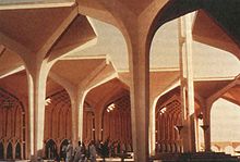
It is one of the architectural works of Minoru Yamasaki, and was completed in 1961. The architecture is a blending of traditional islamic forms with modern technology, for example the flight control tower has the appearance of a minaret. Images of the terminal have been used on Saudi banknotes. The terminal is viewed as having influenced the design of a number of important buildings throughout the Middle East.[citation needed]
External links
- Dhahran International Airport (in Arabic)
- Airport information for OEDR at World Aero Data. Data current as of October 2006.

This article about transport in Saudi Arabia is a stub. You can help Wikipedia by expanding it.
