- Zeitz
-
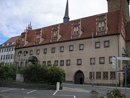
Zeitz Old city hall in Zeitz 
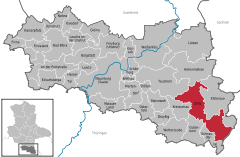
Coordinates 51°2′52″N 12°8′18″E / 51.04778°N 12.13833°ECoordinates: 51°2′52″N 12°8′18″E / 51.04778°N 12.13833°E Administration Country Germany State Saxony-Anhalt District Burgenlandkreis Mayor Volkmar Kunze (FDP) Basic statistics Area 87.15 km2 (33.65 sq mi) Elevation 160 m (525 ft) Population 31,556 (31 December 2010)[1] - Density 362 /km2 (938 /sq mi) Other information Time zone CET/CEST (UTC+1/+2) Licence plate BLK Postal codes 06712, 06724, 06727 Area codes 03441, 034423, 034426 Website German: Stadt Zeitz Zeitz is a town in the Burgenlandkreis district, in Saxony-Anhalt, Germany. It is situated on the river Weiße Elster, in the middle of the triangle of the federal states Saxony-Anhalt, Thuringia and Saxony.
History
Zeitz was first recorded under the name Cici in the synode of Ravenna in 967. Between 965 and 982, it was the chief fortress of the March of Zeitz. Between 968 and 1028 Zeitz was a bishops residence which has later been laid to Naumburg. But since the end of the 13th century the bishops were again residing in their castle at Zeitz. The Herrmannsschacht (Built in 1889) is one of the oldest brick factories in the world.
A bombing target of the Oil Campaign of World War II, the BRABAG plant northeast of Zeitz used lignite coal to synthesize Ersatz oil[2] – forced labor was provided by the nearby Wille subcamp of Buchenwald in Rehmsdorf and Gleina.[citation needed] In the middle of the 1960s work started on the "Zeitz-Ost" residential area, and in the mid-1980s, housing estates such as the "Völkerfreundschaft" (English: International Friendship) were built.
On the 18th August 1976, the Protestant clergyman Oskar Brüsewitz from Rippicha burnt himself to death in front of the Michaeliskirche. This was a protest against the DDR system and was one of the roots of the 1989 uprising.
The town was an industrial centre until German Reunification made many companies in eastern Germany uncompetitive. The town still has a large sugar factory.
Main sights
Zeitz sights are predominantly situated along the Romanesque Road (point 52).
- Schloss Moritzburg, a baroque-style castle with the cathedral of St. Peter and Paul. The 10th century crypt displays 17th century tin coffins including that of Moritz, Duke of Saxony.[citation needed]
- Michaeliskirche (1154), originally a Roman basilica and contains a 1517 original of Martin Luther's 95 Theses.
- Town Hall (1509, rebuilt in 1909). It is a Gothic structure that, together with restored houses and 3 market-places, provides Zeitz' medieval appearance.
- Herrmannsschacht, a technical monument in a former brick factory.
References
- ^ "Bevölkerung der Gemeinden nach Landkreisen" (in German). Statistisches Landesamt Sachsen-Anhalt. 31 December 2010. http://www.statistik.sachsen-anhalt.de/download/stat_berichte/6A102_hj_2010_02.pdf.
- ^ Becker, Peter W. (1981). "The Role of Synthetic Fuel In World War II Germany: implications for today?". Air University Review (Maxwell AFB).
Towns and municipalities in the district of Burgenlandkreis An der Poststraße | Bad Bibra | Balgstädt | Droyßig | Eckartsberga | Elsteraue | Finne | Finneland | Freyburg | Gleina | Goseck | Gutenborn | Hohenmölsen | Kaiserpfalz | Karsdorf | Kretzschau | Lanitz-Hassel-Tal | Laucha an der Unstrut | Lützen | Meineweh | Mertendorf | Molauer Land | Naumburg | Nebra | Osterfeld | Schnaudertal | Schönburg (Saale) | Stößen | Teuchern | Weißenfels | Wethau | Wetterzeube | Zeitz Categories:
- Towns in Saxony-Anhalt
- Burgenlandkreis
- Oil Campaign of World War II
Wikimedia Foundation. 2010.


