- Meineweh
-
Meineweh 
 MeinewehLocation of Meineweh within Burgenlandkreis district
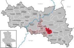

Coordinates 51°5′N 11°58′E / 51.08333°N 11.96667°ECoordinates: 51°5′N 11°58′E / 51.08333°N 11.96667°E Administration Country Germany State Saxony-Anhalt District Burgenlandkreis Municipal assoc. Wethautal Local subdivisions 2 Mayor Manfred Kalinka Basic statistics Area 25.24 km2 (9.75 sq mi) Population 1,077 (31 December 2010)[1] - Density 43 /km2 (111 /sq mi) Other information Time zone CET/CEST (UTC+1/+2) Licence plate BLK Postal codes 06721, 06667 Area codes 034422, 034425, 034445 Website www.vgem-wethautal.de Meineweh is a municipality in the Burgenlandkreis district, in Saxony-Anhalt, Germany. It was formed on 1 January 2010 as Anhalt Süd by the merger of the former municipalities Meineweh, Pretzsch and Unterkaka and renamed on the 1 August 2011 as Meineweh[2]
References
- ^ "Bevölkerung der Gemeinden nach Landkreisen" (in German). Statistisches Landesamt Sachsen-Anhalt. 31 December 2010. http://www.statistik.sachsen-anhalt.de/download/stat_berichte/6A102_hj_2010_02.pdf.
- ^ "Aktuelle Bekanntmachungen der Gemeinde Meineweh" (in German). Verbandsgemeinde Wethautal. 20 May 2011. http://www.vgem-wethautal.de/?id=104262001207&cid=104262003933. Retrieved 02 August 2011.
Towns and municipalities in the district of Burgenlandkreis An der Poststraße | Bad Bibra | Balgstädt | Droyßig | Eckartsberga | Elsteraue | Finne | Finneland | Freyburg | Gleina | Goseck | Gutenborn | Hohenmölsen | Kaiserpfalz | Karsdorf | Kretzschau | Lanitz-Hassel-Tal | Laucha an der Unstrut | Lützen | Meineweh | Mertendorf | Molauer Land | Naumburg | Nebra | Osterfeld | Schnaudertal | Schönburg (Saale) | Stößen | Teuchern | Weißenfels | Wethau | Wetterzeube | Zeitz Categories:
- Municipalities in Saxony-Anhalt
- Burgenlandkreis geography stubs


Wikimedia Foundation. 2010.