- Hohenmölsen
-
Hohenmölsen 

 HohenmölsenLocation of the town of Hohenmölsen within Burgenlandkreis district
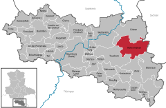

Coordinates 51°9′23″N 12°5′53″E / 51.15639°N 12.09806°ECoordinates: 51°9′23″N 12°5′53″E / 51.15639°N 12.09806°E Administration Country Germany State Saxony-Anhalt District Burgenlandkreis Town subdivisions 6 Mayor Hans Dieter von Fintel (CDU) Basic statistics Area 75.31 km2 (29.08 sq mi) Elevation 149 m (489 ft) Population 10,567 (31 December 2010)[1] - Density 140 /km2 (363 /sq mi) Other information Time zone CET/CEST (UTC+1/+2) Licence plate BLK Postal code 06679 Area code 034441 Website www.stadt-hohenmoelsen.de  Hohenmölsen (help·info) is a town in the Burgenlandkreis district, in Saxony-Anhalt, Germany. It is situated approx. 10 km southeast of Weißenfels, and 27 km southwest of Leipzig.
Towns and municipalities in the district of Burgenlandkreis An der Poststraße | Bad Bibra | Balgstädt | Droyßig | Eckartsberga | Elsteraue | Finne | Finneland | Freyburg | Gleina | Goseck | Gutenborn | Hohenmölsen | Kaiserpfalz | Karsdorf | Kretzschau | Lanitz-Hassel-Tal | Laucha an der Unstrut | Lützen | Meineweh | Mertendorf | Molauer Land | Naumburg | Nebra | Osterfeld | Schnaudertal | Schönburg (Saale) | Stößen | Teuchern | Weißenfels | Wethau | Wetterzeube | Zeitz
References
- ^ "Bevölkerung der Gemeinden nach Landkreisen" (in German). Statistisches Landesamt Sachsen-Anhalt. 31 December 2010. http://www.statistik.sachsen-anhalt.de/download/stat_berichte/6A102_hj_2010_02.pdf.
Categories:- Towns in Saxony-Anhalt
- Burgenlandkreis
- Burgenlandkreis geography stubs


Wikimedia Foundation. 2010.