- Col de la Lombarde
-
Col de la Lombarde 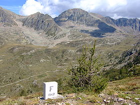
A frontier marker on the col de la LombardeElevation 2,350 m (7,710 ft) Traversed by SP.225 / D.97 Location Location of Col de la Lombarde
 Col de la Lombarde
Location Cuneo  Italy
Italy
Alpes-Maritimes France
Range Alps Coordinates 44°12′8″N 07°09′1″E / 44.20222°N 7.15028°ECoordinates: 44°12′8″N 07°09′1″E / 44.20222°N 7.15028°E Col de la Lombarde (or Colle della Lombarda) (el. 2350 m.) is a high mountain pass above the ski resport of Isola 2000 on the border between France and Italy.
Contents
Details of the climb
From Italy, the climb starts at Vinadio and is 21.5 km long. Over this distance, the climb is 1447 m. (an average percentage of 6.9%), with the steepest sections at 9.1% (although some bends reach over 14%).
From France, the climb starts at Isola 2000 and is 21.2 km long. Over this distance, the climb is 1477 m. (an average percentage of 7%), with the steepest sections at 9.3% at the foot of the climb.
Tour de France
In 2008 the Tour de France crossed the pass for the first time, approaching from Italy via Vinadio on the 157 km sixteenth stage from Cuneo to Jausiers.
Appearances in Tour de France
Year Stage Category Start Finish Leader at the summit 2008 16 HC Cuneo Jausiers Stefan Schumacher See also
- List of highest paved roads in Europe
- List of mountain passes
External links
- Preview of Bonette Stage in 2008 Tour de France
- Profile on climbbybike.com
- Le col de la Lombarde dans le Tour de France (French)
Categories:- Mountain passes of France
- Mountain passes of the Alps
- 2008 Tour de France
- Climbs in cycle racing
- France–Italy border crossings
- Provence-Alpes-Côte d'Azur geography stubs


Wikimedia Foundation. 2010.