- Chasseral Pass
-
Chasseral Pass 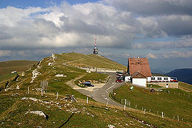
Chasseral PassElevation 1,502 m (4,928 ft) Traversed by Road Location Location of Chasseral Pass
 Chasseral Pass
Location  Switzerland
Range Jura Mountains Coordinates 47°08′05″N 07°03′40″E / 47.13472°N 7.06111°ECoordinates: 47°08′05″N 07°03′40″E / 47.13472°N 7.06111°E Chasseral Pass (German: Gestler) (el. 1502 m.) is a high mountain pass in the Jura Mountains in the canton of Berne in Switzerland. It is named after a nearby mountain (el. 1607).
Contents
Weather
Climate data for Chasseral Pass Month Jan Feb Mar Apr May Jun Jul Aug Sep Oct Nov Dec Year Average high °C (°F) −0.6
(30.9)−0.9
(30.4)0.3
(32.5)3.2
(37.8)7.9
(46.2)11.3
(52.3)14
(57)13.3
(55.9)11
(52)8
(46)2.6
(36.7)0.6
(33.1)5.9 Daily mean °C (°F) −3.1
(26.4)−3.4
(25.9)−2
(28)0.5
(32.9)4.8
(40.6)8.2
(46.8)10.7
(51.3)10.4
(50.7)8.3
(46.9)5.4
(41.7)0.2
(32.4)−2
(28)3.2 Average low °C (°F) −5.5
(22.1)−5.7
(21.7)−4.1
(24.6)−1.9
(28.6)2.2
(36.0)5.3
(41.5)7.7
(45.9)7.6
(45.7)5.6
(42.1)2.9
(37.2)−2.2
(28.0)−4.5
(23.9)0.6 Precipitation mm (inches) 163
(6.42)166
(6.54)130
(5.12)82
(3.23)101
(3.98)118
(4.65)99
(3.9)90
(3.54)83
(3.27)78
(3.07)114
(4.49)174
(6.85)1,396
(54.96)Avg. precipitation days 13.7 11.4 13.6 11.5 14.7 13.3 9.9 10.7 9.5 9.7 11.2 13.6 142.8 Source: MeteoSchweiz [1] See also
- List of highest paved roads in Europe
- List of mountain passes
- List of the highest Swiss passes
References
- ^ "Average Values-Table, 1961-1990" (in German, French, Italian). Federal Office of Meteorology and Climatology MeteoSwiss. http://www.meteoswiss.admin.ch/web/de/klima/klima_schweiz/tabellen.html. Retrieved 8 May 2009.
External links
Aargau • Appenzell Ausserrhoden • Appenzell Innerrhoden • Basel-City • Basel-Country • Berne • Fribourg • Geneva • Glarus • Graubünden • Jura • Lucerne • Neuchâtel • Nidwalden • Obwalden • Schaffhausen • Schwyz • Solothurn • St. Gallen • Thurgau • Ticino • Uri • Valais • Vaud • Zug • Zürich
Categories:- Mountain passes of Switzerland
- Mountain passes of the Jura
- Canton of Bern
- Highest points of Swiss cantons
- Canton of Bern geography stubs


Wikimedia Foundation. 2010.