- Dagami, Leyte
-
Dagami, Leyte — Municipality — 
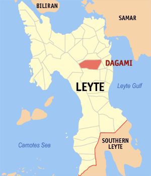
SealDagami's location on the Map of Leyte. Location in the Philippines
 Dagami, Leyte
Coordinates: 11°3′40″N 124°54′11″E / 11.06111°N 124.90306°ECoordinates: 11°3′40″N 124°54′11″E / 11.06111°N 124.90306°E Country  Philippines
Region Eastern Visayas (Region VIII) Province Leyte District 2nd District of Leyte Founded 1600s - 1700s Barangays 65 Government – Mayor Esmeralda B. Ortega Area[1] – Total 161.65 km2 (62.4 sq mi) Population (2007) – Total 30,451 – Density 188.4/km2 (487.9/sq mi) Time zone PST (UTC+8) ZIP code Income class 5th Class; Partially urban Dagami is a municipality in the Province of Leyte, Philippines. According to the August 2007 census of population in the Philippines, the town has a population of 30,451 inhabitants[2] with a density of 188 persons per square kilometer. It is bounded in the north by the municipality of Pastrana, on the northwest by Albuera, on the southwest by Burauen, and on the south by the town of Tabon-tabon, southeast by the town of Tanauan and on the northeast by Palo. The town is located thirty two kilometers from the provincial capital, Tacloban City.
It is classified as a third class municipality and mere dependent on agriculture such as coconut, rice and corn farming. The employment rate is 63% of the total population workforce in the municipality. Its total land area of 161.5 square kilometers, equivalent to 16,165 hectares. More than half of its plains on the eastern side is used to rice and corn farming while on the western side is forestland. In between the forestland and the plains is coconut plantations.
The town of Dagami is mostly famous for its local delicacies called "Binagol" (made with sweetened mashed giant taro called talian and packed in half of a leaf-covered coconut shell), "Moron" (sweetened sticky rice stick with peanuts and chocolate) and "Sagmani".
Contents
History
In 1957, the barrios of Capahu-an and Guingawan were transferred to the town of Tabontabon.[3], which used to be a barangay of Dagami.
Government
Administrative Division
Dagami is politically subdivided into 65 barangays and two non-legislative districts. For purposes of education administration, the municipality is divided into Dagami North District and Dagami South District.
- Abaca
- Abre
- Balilit
- Banayon
- Bayabas
- Bolirao
- Buenavista
- Buntay
- Caanislagan
- Cabariwan
- Cabuloran
- Cabunga-an
- Calipayan
- Calsadahay
- Caluctogan
- Calutan
- Camono-an
- Candagara
- Canlingga
- Cansamada East
- Digahongan
- Guinarona
- Hiabangan
- Hilabago
- Hinabuyan
- Hinologan
- Hitumnog
- Katipunan
- Los Martires
- Lobe-lobe
- Macaalang
- Maliwaliw
- Maragondong
- Ormocay
- Palacio
- Panda
- Patoc
- Plaridel
- Sampao West Pob. (Dist. 8)
- Lapu-lapu Pob. (Dist. 2)
- Lusad Pob. (Dist. 6)
- Sampao East Pob. (Dist. 9)
- San Antonio Pob. (Dist. 5)
- San Jose Pob. (Dist. 1)
- Sta. Mesa Pob. (Dist. 7)
- Tunga Pob. (Dist. 4)
- San Roque Pob. (Dist. 3)
- Poponton
- Rizal
- Salvacion
- San Benito
- Santo Domingo
- Sirab
- Tagkip
- Tin-ao
- Victoria
- Balugo
- Cansamada West
- Capulhan
- Lobe-lobe East
- Paraiso
- Sampaguita
- Sawahon
- Talinhugon
- Tuya
Finance
Dagami's total Internal Revenue Allotment (IRA) for fiscal year 2009 is P49,212,979, placing the town at no. 17 among the 41 towns of Leyte. From year 2003 to 2009 alone, Dagami has generated P249,089,980 for the municipal government. This is on top of local revenue sources which are the business and real property taxes including levies, fees and other charges.[citation needed]
FISCAL YEAR AMOUNT OF IRA 2009 49,212,979 2008 42,031,499 2007 37,554,040 2006 34,028,285 2005 28,745,616 2004 28,750,702 2003 28,766,859 Etymology
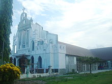 St. Joseph Parish Church, where the statue of the town's patron saint, St. Joseph, is enshrined
According to legend, the island of Leyte was once divided into kingdoms or sultanates:[citation needed]
- The most powerful sultanate in the island was Dagaran, the sultanate ruled by Diwaranda Mohammed. He had daughter named Sayajamburan who was sought by men everywhere. The nearby kingdoms were Bumbaran and Kahagna, sultanates of King Mapandara and King Mabanig, respectively. King Mapandara had a son named Bantugan who was the commander of his father’s army and was sought after by many women because of his strength and good looks. Sayajamaburan was secretly enamored by Bantugan’s physical and intellectual prowess. Bantugan has asked of her hand but was refused although he knew he had hopes of winning her in the end. The ruler of Kahagna, King Mabanig, was also a close rival of Bantugan. He was wealthy and got along well with everyone. When Sayajamaburan’s father was dying, he chose Bantugan as his daughter’s husband. Two days before the scheduled wedding, there was rejoicing everywhere except for King Mabanig who declared war against Bantugan’s kingdom. Bantugan came out victorious and the wedding took place. Bumbaran, Dagaran and Kahagna then became one by affinity and conquest. The fusion of the three kingdoms made Dagara more powerful and respected.
In 1478, two hundred years after the three sultanates unite into one kingdom, changes took place. Its capital, Dagilan, increased in population. The culture and social life of the kingdom further evolved with the entry of the Chinese and the Hindus. The people engaged in trade both with Asia and Europe.
When the Spanish conquistadors arrived in Leyte in 1521, trade mostly took place in the villages bordering the sea, where Dagilan was located.
Locals indicate the name "Dagami" first arose during a confrontation between a group of Spaniards and a group of farmers during the Spanish colonial period:
“ One harvest season, Spanish soldiers inquired a group of men and women harvesting rice nearby the name of the community that was a few meters away. The natives thought that they were asking for a definite term for the field after rice had been harvested and answered, "Dinagami, a Senior." The Spanish had such difficulty in pronouncing Dinagami that the natives ridiculed them. Having felt insulted, one of the civil guards shouted angrily in Spanish, "Dagami or Dawian makes no difference! This place is Dagami, Dagami, Dagami! You Indios! What a queer language you speak." From then on, Dagilan was changed to Dagami by the village folk who thought the name was most suited for the place. ” Ethnology
The people of Dagami speak Waray-Waray, the native dialect of Leyte and Samar. The origin of the dialect can be traced to Maranao migrants from Mindanao in what is considered to be the modern day Western and Northern Mindanao.
Some words similar to Maranao dialect:
Direction: South Waray - Ilawod Maranao - Si Ilud (meaning lower valley)
North Waray - Iraya Maranao - Si Raya (meaning upper valley)
There are plenty of Waray words that has similar meaning to the Maranao dialect. This confirms the legend's probability of being true.
Economy
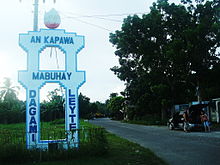 Entering Dagami Town Proper near the Town Cemetery.
Rice and coconut production is the primary economic source of income for the townsfolk. Aside from farming, food processing is another source of income for the town of Dagami. Recently, an upsurge in labor export (OFWs) have contributed to remittances of income from abroad. Commercial businesses are limited to retailing while trading activities are limited to rice and copra trading.
Despite popularity of its indigenous food product - the Binagol, Dagami has yet to maximize its economic potentials, such as creation of labor during its production line, income to be generated from sales, and revenue for the local government in terms of income taxes.
Chief economic products of the municipality are the following:
- Copra
Production of copra - a by-product of coconut tree fruit is the main industry of the townfolks. The growth of local economy is highly dependent on copra production due to price fluctuation in the market of its by-products such as oil, dissicated coconuts, and other raw materials made from leaves, bark, and the coconut fruit itself.
- Rice
Rice farming is the second source of livelihood for the people of Dagami. Almost half of the land area is planted with different variety of rice stocks. It is likewise the second most traded product in the town next to copra.
- Binagol
The town of Dagami is known for its local delicacy, the "Binagol" - a sweet, glutinous mixture of cassava, legume crop and other ingredients cooked with filling made of sugar, coconut and milk placed in a coconut shell or "bagul" and wrapped with banana leaves. Dagami also has other local delicacies such as "Sagmani", and "Moron".
The "binagol" is sold in the city market primarily in Tacloban City while some reach the international markets.
- Tuba
"Tuba", is a well-known drink to Leyteños. Aside from copra production, the gathering of this product from coconut sap is another source of livelihood for Dagami-ons. "Tuba" is then traded in the market by local entrepreneurs but often sold directly by the gatherers.
Education
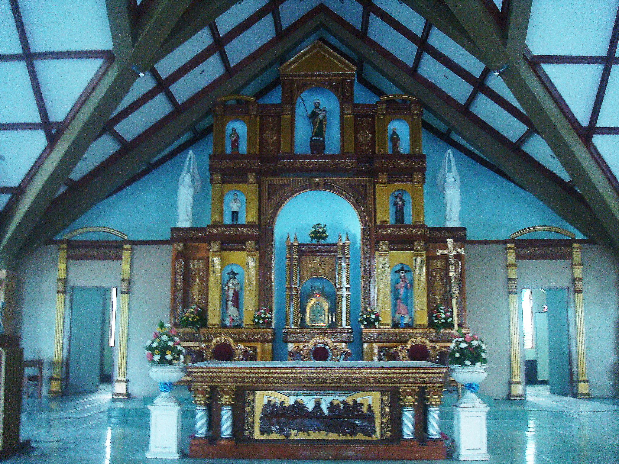
 The main altar of St. Joseph Parish Church, Dagami. The statue of the town's patron saint can been seen at the highest point of the altar.
Local townfolks recognize the importance of education, hence local leaders are working very hard to provide the people access to education as most prominent higher educational institutions in Leyte are in the provincial capital, Tacloban City, Tabontabon, and Tanauan.
- Primary Schools
Almost all barangays in the town have primary and intermediate schools. The two major elementary schools are Dagami North Central School and Dagami South Central School situated just a few meters apart in the town proper. Other major elementary schools are Patoc Elementary School in the north, Guinarona Elementary School in the West and Balilit Elementary School in the south.
- Secondary Schools
The town has three public high schools and one private school run by the local parish. The local public secondary schools are Santa Mesa National High School located in the town proper, Patoc National High School in the north, Guinarona National High School in the west and the private-run Saint Joseph High School in the town center.
- Tertiary Institution
Huron Institute which opened as a vocational training center assisted by the Technical Education and Skills Development Authority or TESDA at Barangay Patoc closed down due to lack of funding.
Tourism
- Rivers
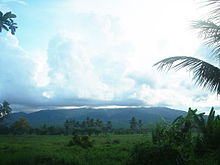 Mount Amandewing, the highest point in Leyte Province.
The town of Dagami is traversed by many rivers and streams upland. The biggest river is Panda River which cuts across the town's northeast section. Sawahon River is among its tributaries which is also joined up stream by its major tributaries such as Hilabago River, Kababatuan Dako (Greater Stones) River and Kababatuan Guti (Smaller Stones) River.
During the rainy season, when these rivers rise, the downtown or Poblacion is flooded causing damages to property. A river dike which is also a diversion road was built to protect the town center. But as the river rises higher than the dike, it overflows causing more water to flood the town center.
- Mountains
The majestic Mount Amandiwing located near Dagami is the highest peak in Leyte. The imposing mountain is a protected natural park where wildlife such as pigs, deers and monkeys are hunted by local hunters despite by a local ban. During the 1960s, a logging concession was permitted to cut its virgin forests but the concessionaire never replanted trees. Locals exploited the situation by farming the logged area and creating coconut plantations.
The mountain is best viewed from the town proper. On approach to the town proper, the mountain is an imposing majestic hill where smokes bellow from different parts like chimneys. Up in the mountain near its peak, one could see the vast Pacific Ocean.
Municipal Government
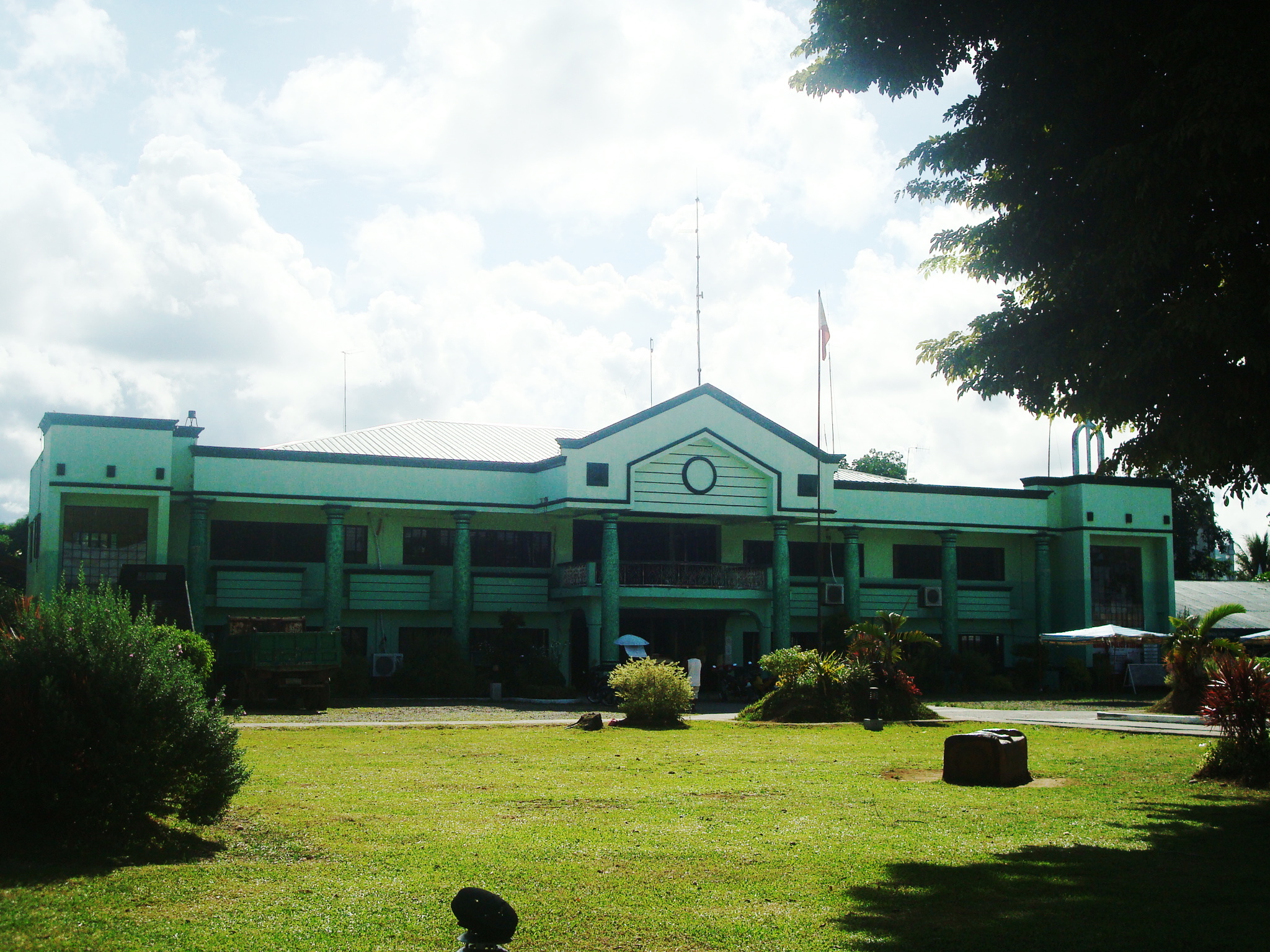
 Municipal Hall of Dagami, Leyte
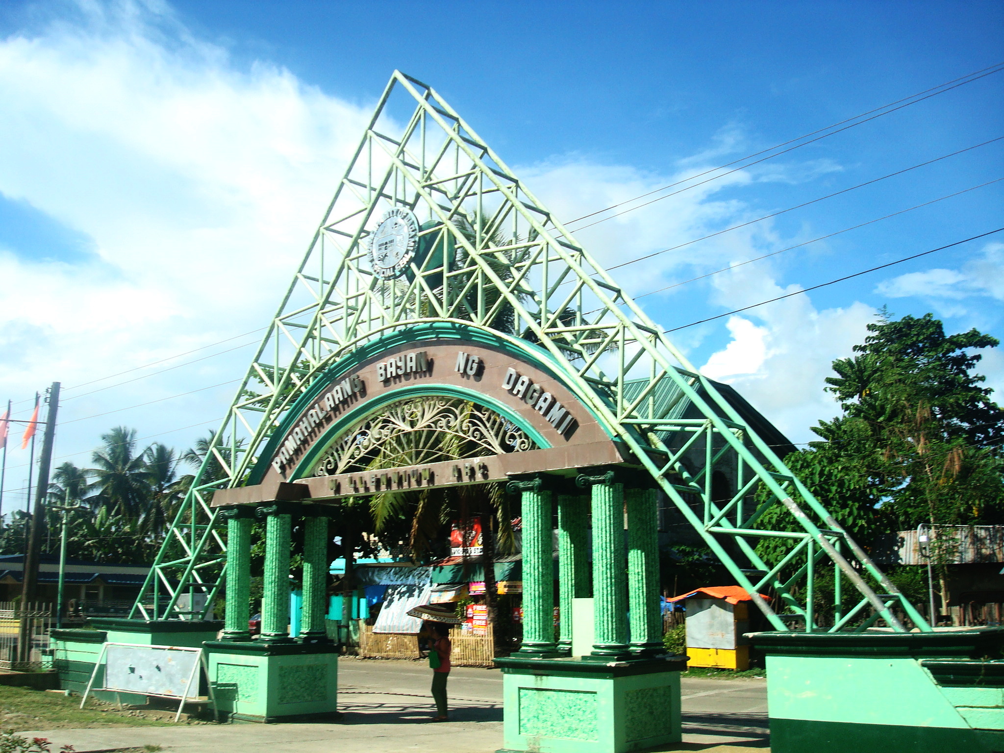
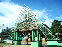 The Millennium Arc - the main entrance to the town square, where the Dagami Municipal Hall is located.
Municipal Mayors of Dagami - 1900-Present
Mayor Starting Date Ending Date 1 Capitan Fabian Perido 1900 1906 2 Capitan Cecilio Limchaypo 1907 1910 3 Capitan Simeon Cañete 1911 1914 4 Capitan Ciriaco Bayona 1915 1921 5 Capitan Antonio Ubaldo 1922 1924 6 Atilano Cinco 1925 1937 7 Homobono Bardillon 1938 1941 8 Cesar Sudario, Sr. 1941 1944 9 Meliton Iroy, Sr. 1945 1945 10 Pablo Ontimare, Sr. January 1947 June 1947 11 Fermin Lymchaypo June 1947 December 1947 12 Cesario Sudario, Sr. 1948 1951 13 Fernando Sudario, Sr. 1952 1955 14 Pablo Ibañez 1956 1959 15 Felipe Quinia 1960 1963 16 Serafin Nicolas, Sr. 1964 1967 17 Juan C. Vertulfo, Jr. 1968 1980 18 Necitas M. Martillo 1980 April 1986 19 Pablo M. Ontimare, Jr. April 1986 November 1986 20 Olimpio O. Salvatierra (Officer-In-Charge) December 1986 January 1987 21 Adolfo A. Ortega 1987 1992 22 Benedicto C. Ortega June 30, 1992 June 30, 1995 23 Adolfo A. Ortega June 30, 1995 October 2001 24 Gavino Dario O. Berino III October 20, 2001 June 30, 2004 25 Esmeralda B. Ortega July 1, 2004 present The Official Seal of the Municipality of Dagami
 Hon. Esmeralda Ortega.
The Dagami Municipal Seal represents the town's humble achievements. The center of the seal shows the town's Municipal Hall (above), the seat of Dagami's local government. Its upper left side features the St. Joseph Parish of Dagami and the other side shows a faucet that represents Dagami as the source of fresh water of the Leyte Metropolitan Water District (LMWD), the local distributor of fresh water in the 1st District of Leyte, namely where the capital of the Province is, Tacloban City. The lower part of the Seal on the left side symbolizes the Municipality's dependency on agriculture, and the other side features the local delicaicies of the town, especially the "Binagol" or sometimes known as "Lidguid". The major colors of the seal are green and yellow, the colours of the St. Joseph Parish, where the statue of the town's Patron Saint, St. Joseph is enshrined and beautifully presented in a wooden and hand-decorated altar.
The Municipal Mayor
The incumbent Municipal Mayor of Dagami is Hon. Esmeralda B. Ortega, popularly known to Dagamin-ons as "Nene"—the first woman to hold such an office. Ortega was first elected in May 2004 against then-Mayor Gavino Berino III. She was successful in her bid for a second term and took office on June 30, 2010.
Additional reading
- Leyte: Towns' Historical Legends By Francisco Tantuico, Jr.
- 2007 Town Fiesta Programme by the Dagami Fiesta Committee
References
- ^ CY 2008 Final Internal Revenue Allotment for LGUs, website Department of Budget and Management, 2008.
- ^ National Statistics Office, Republic of the Philippines - Total Population, Household Population and Number of Households by Province, City, Municipality and Barangay: Municipality of Dagami, Province of Leyte, Region VIII
- ^ "An Act Transferring the Barrios of Capahu-an and Guingawan, Municipality of Dagami, Province of Leyte, to the Municipality of Tabontabon". LawPH.com. http://lawph.com/statutes/ra1649.html. Retrieved 2011-04-12.
- ^ National Statistics Office, Republic of the Philippines - Total Population, Household Population and Number of Households by Province, City, Municipality and Barangay: as of May 1, 2000 (total population includes institutional population)
External links
Municipalities - Abuyog
- Alangalang
- Albuera
- Babatngon
- Barugo
- Bato
- Burauen
- Calubian
- Capoocan
- Carigara
- Dagami
- Dulag
- Hilongos
- Hindang
- Inopacan
- Isabel
- Jaro
- Javier
- Julita
- Kananga
- La Paz
- Leyte
- MacArthur
- Mahaplag
- Matag-ob
- Matalom
- Mayorga
- Merida
- Palo
- Palompon
- Pastrana
- San Isidro
- San Miguel
- Santa Fe
- Tabango
- Tabontabon
- Tanauan
- Tolosa
- Tunga
- Villaba
Component city - Baybay
Independent component city Highly urbanized city - Tacloban
Categories:- Municipalities of Leyte


Wikimedia Foundation. 2010.