- Mulanje Massif
-
Mount Mulanje 
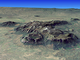
Composite satellite image of Mt. MulanjeElevation 3,002 m (9,849 ft) [1] Prominence 2,319 m (7,608 ft) [1] Listing Country high point
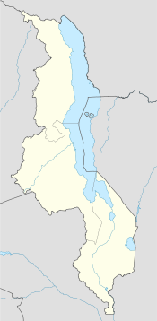
UltraLocation Location of Mount Mulanje in Malawi Location  Malawi
Coordinates 15°56′59″S 35°35′37″E / 15.94972°S 35.59361°ECoordinates: 15°56′59″S 35°35′37″E / 15.94972°S 35.59361°E[1][2] Geology Type Inselberg The Mulanje Massif, also known as Mount Mulanje, is a large monadnock in southern Malawi near the city of Blantyre, rising sharply from the surrounding plains of Chiradzulu, and the tea-growing Mulanje district. It measures approximately 13x16 miles (22x26 kilometres) and has a maximum elevation of 3,002m at its highest point, Sapitwa Peak.
Much of the Massif consists of rolling grassland at elevations of 1800-2200m, intersected by deep forested ravines. It has many individual peaks reaching heights of over 2500m, including Chambe Peak, the West Face of which is the longest rock climb in Africa.
The Massif was formed by the extrusion of magma into the Earth's crust about 130 million years ago. The surrounding rock eroded away over time, leaving behind the erosion-resistant igneous rock of the Mulanje Massif. The first European to report seeing the Massif was David Livingstone in 1859, but archeological investigation reveals evidence of human visits to the Massif from the Stone Age onwards. The elevation of the mountain is high enough for it to disturb upper level air flow and induce rain clouds to form around it, making it an important source of rain water at the head of almost every river that runs through this part of Malawi.
The forested slopes of the Massif support a sizable timber industry. At one time there was a cableway to transport timber from the edge of the plateau down to the Likhubula Forestry Station, but it fell into disrepair, and currently planks are carried down manually.
The mountain itself is part of the protected Mulanje Mountain Forest Reserve. The native Mulanje Cypress (Widdringtonia whytei) has been so heavily logged that it is considered endangered and the park contains the last remaining stands of this tree, as well as a number of other plant and animal species—many of them endemic to the area. Examples include forest butterflies, birds such as the cholo alethe and White-winged Apalis, a dwarf chameleon, geckos, skinks, the Squeaker Frog, and a rare limbless burrowing skink species. The land around the park is threatened by growing population, land use patterns such as forest clearing for farming and firewood, and invasive species such as Mexican Pine and Himalayan Raspberry.
The Massif is popular for hiking and climbing, and has several mountain huts scattered across it which are maintained by the Malawi Mountain Club and the Malawi Forestry Department. Sapitwa peak was first climbed in 1894, and is now the most popular climb on the plateau.
Climate
 Mulanje Massif 3D
The climate of the larger Mulanje area is strongly influenced by the equatorial low pressure area, where the north-east trades of the Northern Hemisphere converge with the south-east trades of the Southern Hemisphere. This area is known as the Inter-Tropical Convergence Zone (ITCZ). On satellite Images the ITCZ is mostly seen as a long band of clouds in the Equatorial region, the main effect of the ITCZ is the creation of dry- and rainy-seasons in the Equatorial area.
If we focus on equatorial and central Africa, we can see, that the ITCZ moves as southern as northern Zimbabwe. Therefore also the greater Mulanje area is affected by the ITCZ despite of is location, roughly 1800 kilometers south of the equator.
Most affected by the ITCZ in the Mulanje Area, is the Mulanje Massif, because its unique position as a “mountain island”, rising up more than 2500 Meters above the plains around. This setting is responsible for the Massifs role as a rain barrier that forces the clouds to come down in the form of rain. This becomes very visible if we take a look at the annual normal rainfalls, on and around the massif. On plateau level, at around 2000 m.a.s.l., we annually experience more than 100 inches of rain, however, in the low plains around the foot of the Massif, the annual rainfalls, range around 40 inch. In the plains around the Mountain, it normally only rains in the rainy season, while it rains all year long, on plateau level. The rains are just more intense and frequent then in the dry season.
But, there are still differences in the amounts of rain, around the Massif. The south-west face of the Mountain, is the weather side, around Likhabula, Lichenya and Mulanje Boma, which experiences the highest amounts of rain, due to the south-east trades of the southern hemisphere, that drive the moist air from Zambia and the Democratic Republic of the Congo into the Mulanje region. Therefore the North-west face of the Massif experiences lesser rains, as it is situated in the shadows of the high Peaks of the Massif.
Temperature wise, the months of the dry season are the coolest months of the Year, and probably the nicest climate to go hiking in the massif (May-August), the wet season (November-April) is not the recommended time to hike in the Massif, as the hiker faces strong rains on the plateau and high temperatures at the ascent.
References
Categories:- Mountains of Malawi
- Monadnocks
Wikimedia Foundation. 2010.

