- Oklahoma State Highway 131
-
State Highway 131
Route information Maintained by ODOT Length: 13.63 mi[2][3] (21.94 km) Existed: 1958[1] – present Major junctions West end:  SH-31 near Coalgate
East end:  US-69 south of Kiowa
Highway system Oklahoma State Highways
Oklahoma turnpike system←  SH-130
SH-132  →
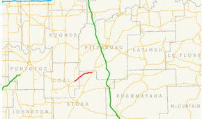
→State Highway 131 (SH-131 or OK-131) is a 13.63 miles (21.94 km)[2][3] state highway in southeastern Oklahoma. It runs through Coal and Atoka Counties. It has no lettered spur routes.
Contents
Route description
SH-131 begins in Coal County 6 miles (9.7 km)[4] northeast of Coalgate, the county seat. From the terminus at State Highway 31, SH-131 heads northeast towards the unincorporated town of Cairo. North of Phillips Hollow, the route crosses a small stream, an eventual tributary of Coal Creek.[5] The highway then crosses the Coal–Atoka county line.
After entering Atoka County, the highway gradually curves onto a east-northeast course, which continues as it passes through Wardville, another incorporated town 8 miles (13 km)[4] northeast of Cairo. SH-131 then becomes a more easterly route. After bridging North Boggy Creek, the route swings around to the north briefly, before returning to a due east heading. The road then crosses Fivemile Creek.[5] Five miles (8.0 km)[4] east of Wardville, it ends at US-69 south of Kiowa.
History
State Highway 131 first appeared on the 1959 state road map. When it was originally commissioned, it began at its present-day western terminus near Cairo, but stopped short of the present-day eastern terminus, instead ending in Wardville.[1] SH-131 had these termini for over twenty years. The route was extended to US-69 in 1985.[6] No further changes to the highway have been made since the extension.
Junction list
County Location Mile[2][3] Destinations Notes Coal 0.00 SH-31Western terminus Atoka 13.63 US-69Eastern terminus 1.000 mi = 1.609 km; 1.000 km = 0.621 mi References
- ^ a b Oklahoma Department of Highways. 1959 Oklahoma Road Map (Map). http://www.odot.org/hqdiv/p-r-div/maps/state-maps/pdfs/1959.pdf. Retrieved 2008-10-31.
- ^ a b c Oklahoma Department of Transportation. 2008 Control Section Maps (Map). p. Coal 15. http://www.odot.org/hqdiv/p-r-div/maps/control-maps/coal.pdf. Retrieved 2008-10-30.
- ^ a b c Oklahoma Department of Transportation. 2008 Control Section Maps (Map). p. Atoka 3. http://www.odot.org/hqdiv/p-r-div/maps/control-maps/atoka.pdf. Retrieved 2008-10-30.
- ^ a b c Oklahoma Department of Transportation. Official State Highway Map (Map) (2008 ed.).
- ^ a b DeLorme (2006). Oklahoma Atlas and Gazetteer (Map). 1:200,000. pp. 54–55.
- ^ Oklahoma Department of Transportation. Official State Map (Map) (1986 ed.). http://www.odot.org/hqdiv/p-r-div/maps/state-maps/pdfs/1986.pdf. Retrieved 2008-10-31.
External links
Categories:- State highways in Oklahoma


Wikimedia Foundation. 2010.