Nyírpilis

Nyírpilis
Nyírpilis
Country  Hungary
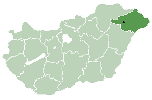
County Szabolcs-Szatmár-Bereg
Area
 – Total 16.34 km2 (6.3 sq mi)
Population (2001)
 – Total 698
 – Density 42.72/km2 (110.6/sq mi)
Time zone CET (UTC+1)
 – Summer (DST) CEST (UTC+2)
Postal code 4376
Area code(s) 42
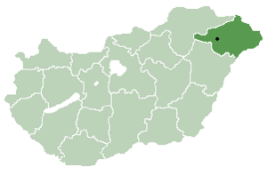
Location of Szabolcs-Szatmar-Bereg county in Hungary

Nyírpilis is a small village in Szabolcs-Szatmár-Bereg county, in the Northern Great Plain region of eastern Hungary.

Geography

It covers an area of 16.34 km2 (6 sq mi) and has a population of 698 people (2001).

Coordinates: 47°47′N 22°11′E / 47.783°N 22.183°E / 47.783; 22.183


Wikimedia Foundation. 2010.

Игры ⚽ Нужно решить контрольную?

Look at other dictionaries:

  • Nyírpilis — Administration …   Wikipédia en Français

  • Nyíregyháza — City center …   Wikipedia

  • Szabolcs-Szatmár-Bereg County — Infobox Hungarian county name =Szabolcs Szatmár Bereg region =Northern Great Plain seat = Nyíregyháza area = 5936 population = 572,423 density = 96 cities = 228Szabolcs Szatmár Bereg is an administrative county (Hungarian: megye ) in north… …   Wikipedia

  • Máriapócs — Country  Hungary County Szabolcs Szatmár Bereg Area    Total 22.09 km2 (8 …   Wikipedia

  • Nagykálló — Country  Hungary County Szabolcs Szatmár Bereg Area  – Total 68.55 km2 (26 …   Wikipedia

  • Nyírtass — Country  Hungary County Szabolcs Szatmár Bereg Area    Total 37.95 km2 (14 …   Wikipedia

  • Baktalórántháza —   Market Town   Aerial photograph: Baktalórántháza Palace …   Wikipedia

  • Csenger — Country  Hungary County Szabolcs Szatmár Bereg Area    Total 36.16 km2 (14&# …   Wikipedia

  • Demecser — Country  Hungary County Szabolcs Szatmár Bereg Area  – Total 36.99 km2 (14 …   Wikipedia

  • Dombrád — Country  Hungary County Szabolcs Szatmár Bereg Area  – Total 51.84 km2 (20&# …   Wikipedia

Share the article and excerpts

Direct link
Do a right-click on the link above
and select “Copy Link”