- Mérk
-
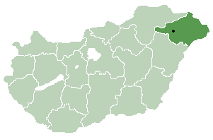
Mérk Country  Hungary
County Szabolcs-Szatmár-Bereg Area - Total 25.08 km2 (9.7 sq mi) Population (2001) - Total 2,328 - Density 92.82/km2 (240.4/sq mi) Time zone CET (UTC+1) - Summer (DST) CEST (UTC+2) Postal code 4352 Area code(s) 44 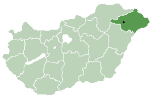 Location of Szabolcs-Szatmar-Bereg county in Hungary
Mérk is a village in Szabolcs-Szatmár-Bereg county, in the Northern Great Plain region of eastern Hungary.
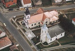 Mérk, temples from above
Geography
It covers an area of 25.08 km2 (10 sq mi) and has a population of 2328 people (2001).
The village of Mérk is situated 62 kilometers southeast of the Hungarian town Nyíregyháza. This area is part of Szabolcs-Szatmár-Bereg county located in the northeast corner of Hungary. In 2003, Mérk has 2390 inhabitants. The number of houses in the community is 750. The village is close to the border between Hungary and Romania that crosses this area in an East to West direction at the River Kraszna. Geographically, the area constitutes a juncture of the sandy Nyírség Plain and the marshlands of Ecsed.
According to some, the name of the village was created by using the one-time very popular old Hungarian proper noun “Mérk” as a base. It is speculated that this proper noun might be rooted in the Slavic proper noun “Mirk”. According to others, however, the village was probably named after Merch, the one-time lord lieutenant of the Krauts living in the area called Szatmár. The community is situated on the boundary between the moderately warm and moderately cold climatic zones. Its flora is primarily characterized by wattles, but one also finds oaks, woods with both soft and hard foliage, and pines. The open vegetation associations include sandy barren-meadows and tussocks, but sedges and purple marshlocks are equally present. The area is covered by meadow soils, moldy sand and marsh soils. Approachability: Take Road #471 (a minor road) from the turnout (exit) at Nyírbátor. The village of Mérk is connected with the two closest towns Mátészalka and Nyírbátor via bus service that runs every day. Direct train service to the village is not available; the closest train station is located in the neighbouring village of Tiborszállás. The first written record of the village dates from 1299 when the area was owned by a person called Miklós. According to the manifestation of a charter written a year later, István (a country judge from the Ákos genus) gave the area to his daughter. In 1318 King Károly I took the area away from the Ákos genus due to their unfaithfulness to the throne. The area then got awarded to Bátori Bereck fia János who belonged to the Gut-Keled genus. From this point on, the land belonged to and thus shared its history with the castle of Ecsed. After 1613 the region became the property of the princes of Transylvania (first, Prince Bethlen, then Prince György Rákóczi). Following the death of Prince Ferenc Rákóczi II, the area became the property of Earl Aspremont through his marriage to Júlia, daughter of Prince Ferenc Rákóczi II. This was the only way to avoid the confiscation of the property from Prince Rákóczi II’s family. In 1724 Sándor Károlyi bought the area from the Aspremont family. Károlyi settled Krauts in the area. From this point on, the region was part of the manor of the Károlyi family until 1945. Following the turn of the 19th and 20th century, the village that was settled by Krauts in the 18th century continued to strongly preserve its cultural insularity. However, the assimilation of the population to the environmental cultures has already started with great intensity. Due to the regulations pertaining new country borders between Hungary and Romania that were included in the Treaty of Trianon (June 4, 1920), the villages in this area that were inhabited by the Krauts were ordered to belong to Romania. From this point on, the village of Mérk is more connected to the Hungarian towns of Mátészalka and Nyírbátor that are approximately 20 km (12 mi) away. From 1920, the Kraut culture started to fade away in the villages (e.g. Csanálos, Fény, Börvely) in this area since the communities now belonged to Romania and thus to the Romanian culture. The relative unity of the villages that were inhabited by the Krauts ceased to exist. During WWI 26 people from the village of Mérk died in action. Following WWII, some 300 people from the village were deported for “malenkij robot” to the Soviet Union due to their Kraut cultural heritage. During this period, many people requested officially to change their Kraut/German names to Hungarian ones. In 1960 the forced creation of the farmer’s cooperative was uneventful in this area, primarily because the sorely tried population did not want to be tried again. In 1990, the village of Mérk was listed by Hungarian public administrators as a village with an independent mayor and an independent representative body.
Legend
According to the almost forgotten legend, as Prince Gábor Báthori was mustering up his army against the Turks, a frightening dragon appeared and tried to hinder the army’s procession. Somebody had to cross swords with the beast in order to avoid being delayed. The Prince was asked whether he dares taking the beast on. The answer was yes. At the location where the Prince uttered the word “yes”, the village called “Mérk” sprang up years later. (The word ‘merek’ in Hungarian means “I dare”.) The story runs mentioning that first it was the shoulder of the dragon that the Prince wounded. At the location where the wounding of the beast took place, the village “Vállaj” got created. (The word “Vállaj” means the lower portion of a shoulder.) When the Prince defeated the beast, he threw its lifeless body into a place where nettles were growing. Later, the village “Csanálos” (old Hungarian word referring to a place where nettles grow) got created at the location. Coat of arms of Mérk The coat of arms of the village of Mérk depicts the moment when the valiant is getting ready to kill the dragon as a test of his courage. Art relics and tourist attractions in the village - The Roman Catholic Church was erected in 1882-84 in honour of St. Peter and St. Paul (eclectic) - The Protestant Church was erected between 1899 and 1914 (eclectic) - The memorial that was erected in honor of the people died in WWII; it is located in the space between the two churches - The tawdry barns (Kraut folklore buildings) - A collection of hunter József Janovszky’s trophy collection. Several people have businesses related to traditional (folklore) activities including net spinning, homespun production (by hand), frail and pad production, embroidery and written embroidery production. The village also has a population of Hungarian Romani (Gypsy) people. Several Romani families have businesses related to Romani folklore music (both instrumental music and singing). The village is close to the River Kraszna where flyfishing opportunities are available. One of the major fishes in the area is the pike.
Categories:- Populated places in Szabolcs-Szatmár-Bereg county


Wikimedia Foundation. 2010.