- Vasco da Gama Bridge
Infobox_Bridge
bridge_name=Vasco da Gama Bridge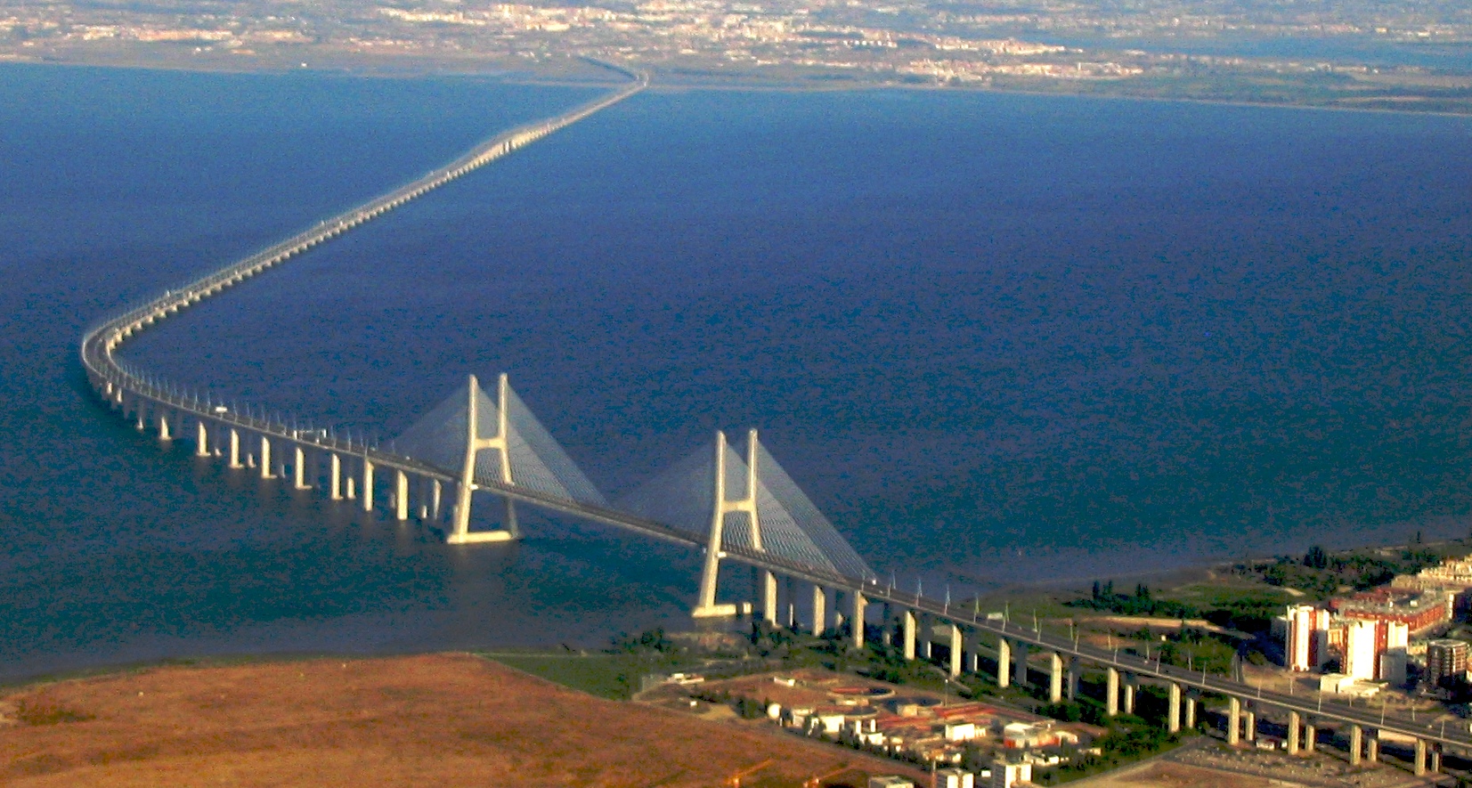
official_name="Ponte Vasco da Gama"
carries= Six road lanes
crosses=Tagus River
locale=Sacavém , north of Lisbon (right bank)
Municipality of Alcochete (left bank)
maint= Lusoponte [http://www.lusoponte.pt/]
design=cable-stayed,viaduct s
mainspan=420 m (1,378 ft)
length=17.2 km (10.7 mi)
width=30 m (98 ft)
open=March 29 ,1998
map_cue=
map_
map_text=
map_width=
lat= 38.7589
long= -9.0387__NOTOC__The Vasco da Gama Bridge (Portuguese: "Ponte Vasco da Gama", pron. IPA2|'põt(ɨ) 'vaʃku dɐ 'gɐmɐ) is acable-stayed bridge flanked byviaduct s and roads that spans the Tagus River nearLisbon , capital ofPortugal . It is the longest bridge inEurope (including viaducts), with a total length of 17.2 km (10.7 mi), including 0.829 km (0.5 mi) for the main bridge, 11.5 km (7.1 mi) in viaducts, and 4.8 km (3.0 mi) in dedicated access roads. Its purpose is to alleviate the congestion on Lisbon's other bridge (25 de Abril Bridge ), and to join previously unconnected motorways radiating from Lisbon.The bridge was opened to traffic on
March 29 ,1998 , 18 months after construction first began, just in time forExpo 98 , the World's Fair that celebrated the 500th anniversary of the discovery byVasco da Gama of the sea route from Europe toIndia .Description
The bridge carries six road lanes, with a speed limit of convert|120|km/h|mph|-0|abbr=on, the same as motorways, except on one section which is limited to convert|100|km/h|mph|-1|abbr=on. On windy, rainy and foggy days, the speed limit is reduced to convert|90|km/h|mph|-0|abbr=on. The number of road lanes will be enlarged to eight when traffic reaches a daily average of 52,000.
;Bridge sections
#North access roads
#North viaduct - convert|488|m|ft|0|abbr=on
#Expo viaduct - convert|672|m|ft|0|abbr=on; 12 sections
#Main bridge - main span: convert|420|m|ft|0|abbr=on; side spans: convert|203|m|ft|0|abbr=on each (total length: convert|829|m|ft|0|abbr=on|disp=/); cement pillars: convert|150|m|ft|0|abbr=on-high; free height for navigation in high tides: convert|45|m|ft|0|abbr=on;
#Central viaduct - convert|6.351|m|ft|2|abbr=on; 80 pre-fabricated sections convert|78|m|ft|0|abbr=on-long; 81 pillars up to convert|95|m|ft|0|abbr=on-deep; height from convert|14|m|ft|0|abbr=on to convert|30|m|ft|0|abbr=on
#South viaduct - convert|3.825|m|ft|2|abbr=on; convert|45|m|ft|0|abbr=on sections; 84 sections; 85 pillars
#South access roads - convert|3.895|m|ft|2|abbr=on; includes the toll plaza (18 gates) and two service areasConstruction and cost
The project was split in four parts, each one built by a different company, and supervised by an independent consortium. There were up to 3,300 workers simultaneously on the project, which took 18 months of preparation and another 18 months of construction.
The bridge has a life expectancy of 120 years, having been designed to withstand wind speeds of convert|250|km/h|mph|-0|abbr=on and hold up to an earthquake 4.5 times stronger than the historical
1755 Lisbon earthquake (estimated at 8.7 on the Richter scale). The deepest foundation piles, up to convert|2.2|m|ft|1|abbr=on in diameter, were driven down to convert|95|m|ft|0|abbr=on undermean sea level . Due to the bridge's length, it was necessary to take theEarth 's curvature into account to site the piers correctly, otherwise a deviation of convert|80|cm|in|0|abbr=on would be apparent at either end of the bridge. Environmental pressure throughout the project resulted in the left-bank viaducts being extended inland to preserve the marshes underneath, as well as the lamp posts throughout the bridge being tilted inwards so as not to cast light on the river below.The cost of the bridge came at zero to the State, as it was built in the BOT (build-operate-transfer) system by Lusoponte, a private consortium which got a 40-year concession on the tolls of both Lisbon bridges. Lusoponte's capital is 50.4% from Portuguese companies, 24.8% French and 24.8% British.
As of
2008 , the toll is €2.25 per passenger car (up to €10.10 per truck) northbound (into Lisbon). There is no toll for southbound traffic.See also
Megaproject ource
*pt icon [http://www.civilium.net/infocil/vgama.shtml www.civilium.net]
External links
* [http://portaldasnacoes.pt/index.php?option=com_content&view=article&id=95&Itemid=98/ Portal das Nações] Discover the Ponte Vasco da Gama
*
* [http://news.bbc.co.uk/1/hi/world/europe/71209.stm BBC news story of bridge opening]
* [http://bridgepros.com/projects/Vasco%20da%20Gama/VascodaGama.htm Bridge Pros profile]
* [http://www.flickr.com/search/?q=Ponte+Vasco+da+Gama Flickr photos of bridge]
* [http://www.factoriaurbana.com/ciudades/puentes.php?id=9&ciudadd=Lisboa Graphic and technical information] Spanish
* [http://flyvbjerg.plan.aau.dk/whatisamegaproject.php What is a megaproject?]
Wikimedia Foundation. 2010.