Olho d'Água das Flores

Olho d'Água das Flores

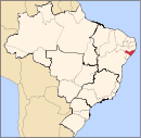
Coordinates: 09°32′09″S 37°17′38″W / 9.53583°S 37.29389°W / -9.53583; -37.29389 Olho d'Água das Flores is a municipality located in the western of the Brazilian state of Alagoas. Its population is 21,775 (2005) and its area is 183 km²[1].

References

  1. ^ IBGE - [1]

Wikimedia Foundation. 2010.

Игры ⚽ Поможем сделать НИР

Look at other dictionaries:

  • Olho D'Agua Das Flores — Admin ASC 2 Code Orig. name Olho d Água das Flores Country and Admin Code BR.02.2705705 BR …   World countries Adminstrative division ASC I-II

  • Olho d'Agua — Olho d Água Cette page d’homonymie répertorie les différents sujets et articles partageant un même nom. Olho d Água peut désigner :  Brésil Olho d Água, municipalité située dans l État de la …   Wikipédia en Français

  • Olho d'Água — Cette page d’homonymie répertorie les différents sujets et articles partageant un même nom. Olho d Água peut désigner :  Brésil Olho d Água, municipalité située dans l État de la …   Wikipédia en Français

  • Olho d'Água do Casado — Coordinates: 09°32′10″S 37°17′38″W / 9.53611°S 37.29389°W / 9.53611; 37.29389 Olho d Água do Casado is a …   Wikipedia

  • Olho d'Água Grande — Coordinates: 10°03′28″S 36°49′01″W / 10.05778°S 36.81694°W / 10.05778; 36.81694 Olho d Água Grande is a …   Wikipedia

  • Olho d'Água do Piauí —   Municipality and town   Country  Brazil Region …   Wikipedia

  • Anexo:Ciudades de Brasil — Contenido: Arriba 0 9 A B C D E F G H I J K L M N Ñ O P Q R S T U V W X Y Z A Abadia de Goiás …   Wikipedia Español

  • Муниципалитеты штата Алагоас — …   Википедия

  • Maragogi —   Municipality   The Municipality of Maragogi Maragogi Downtown …   Wikipedia

  • Coruripe — Coordinates: 10°07′33″S 36°10′33″W / 10.12583°S 36.17583°W / 10.12583; 36.17583 Coruripe is a municipality located …   Wikipedia

Share the article and excerpts

Direct link
Do a right-click on the link above
and select “Copy Link”