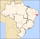
Major Isidoro

Major Isidoro

Coordinates: 09°3155S 36°5906W / 9.53194°S 36.985°W / -9.53194; -36.985 Major Isidoro is a municipality located in the center of the Brazilian state of Alagoas. Its population is 17,878 (2005) and its area is 454 km²[1].

References

  1. ^ IBGE - [1]

Wikimedia Foundation. 2010.

Игры ⚽ Нужна курсовая?

Look at other dictionaries:

  • Major Isidoro — Original name in latin Major Isidoro Name in other language Major Izidoro, Sertaosinho, Sertaozinho, Sertosinho, Sertozinho State code BR Continent/City America/Maceio longitude 9.53222 latitude 36.985 altitude 191 Population 8507 Date 2012 08 03 …   Cities with a population over 1000 database

  • Major Isidoro — Admin ASC 2 Code Orig. name Major Isidoro Country and Admin Code BR.02.2704401 BR …   World countries Adminstrative division ASC I-II

  • Basilica of San Isidoro — Basilica of San Isidoro. The Basilica of San Isidoro is a church in León, Spain, located on the site of an ancient Roman temple. Its Christian roots can be traced back to the early 10th century when a monastery for Saint John the Baptist was… …   Wikipedia

  • List of players from Cuba in Major League Baseball — This is an alphabetical list of baseball players from Cuba which have played in Major League Baseball. NOTOC A* José Acosta * Merito Acosta * Rafael Almeida * Luis (Witto) Aloma * Ossie Alvarez * Rogelio Alvarez * Vicente Amor * Sandy Amorós *… …   Wikipedia

  • ASIA Major — una ex tribus orbis partibus veteribus cognitis, reliquas duas simul acceptas magnitudine superans, in ortum maxime extensa, Indicô, Eoô, et Scythicô Oceanô, perfusa; ab Europa ad occidentem Tanai fluv. mari Euxinô, et Aegaeô separata, ab Africa… …   Hofmann J. Lexicon universale

  • Муниципалитеты штата Алагоас — …   Википедия

  • Мажор-Изидору — Муниципалитет Мажор Изидору Major Isidoro Страна БразилияБразилия …   Википедия

  • Anexo:Ciudades de Brasil — Contenido: Arriba 0 9 A B C D E F G H I J K L M N Ñ O P Q R S T U V W X Y Z A Abadia de Goiás …   Wikipedia Español

  • Maragogi —   Municipality   The Municipality of Maragogi Maragogi Downtown …   Wikipedia

  • Coruripe — Coordinates: 10°07′33″S 36°10′33″W / 10.12583°S 36.17583°W / 10.12583; 36.17583 Coruripe is a municipality located …   Wikipedia

Share the article and excerpts

Direct link
https://en-academic.com/dic.nsf/enwiki/4299790 Do a right-click on the link above
and select “Copy Link”