Gadsden Metropolitan Statistical Area
- Gadsden Metropolitan Statistical Area
Geobox|Settlement
name =
category = Statistical Area
state = Alabama
image_size = 150
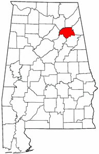
image_caption = Region of Gadsden MSA
seat = Gadsden
area = 1421
area_land = 1385
area_water = 36
area percentage = 2.54%
population_as_of = 2000
population = 103459
density = 75
website = www.etowahcounty.org
Gadsden Metropolitan Statistical Area covers all of Etowah County located in Northeast Alabama. As of 2000, the population was 103,459. It consists of Gadsden and its surrounding towns.
uburbs
The Gadsden Metro area includes the following suburbs:
*Altoona (Altoona is traditionally a historic, self-sufficient town)
*Attalla (Attalla is also traditionally a historic, self-sufficient town)
*Glencoe
*Hokes Bluff
*Mountainboro
*Ohatchee
*Rainbow City
*Reece City
*Ridgeville
*Sardis City
*Southside
*Walnut Grove
ee also
*List of Metropolitan areas of Alabama
Wikimedia Foundation.
2010.
Look at other dictionaries:
North Port–Bradenton–Sarasota, Florida Metropolitan Statistical Area — North Port Bradenton Sarasota MSA Sarasota … Wikipedia
Tallahassee, Florida Metropolitan Statistical Area — The Tallahassee, Florida Metropolitan Statistical Area is a Metropolitan Statistical Area (MSA) consisting of Gadsden County, Jefferson County, Leon County and Wakulla County in the state of Florida in the USA. The principal city in the MSA is… … Wikipedia
Table of United States Metropolitan Statistical Areas — An enlargeable map of the 942 Core Based Statistical Areas (CBSAs) of the United States. The 367 Metropolitan Statistical Areas (MSAs) are shown in red. Main articles: Metropolitan Statistical Area and Core Based Statistical Area … Wikipedia
Highest-income metropolitan statistical areas in the United States — Income in the United States Affluence in the United States Household income in the United States Income inequality in the United States Personal income in the United States Social class in the United States Income by: State (localities by state)… … Wikipedia
Gadsden, Alabama — Gadsden City … Wikipedia
Dothan–Enterprise–Ozark combined statistical area — Location of the Dothan Enterprise Ozark CSA and its components: Dothan Metropolitan Statistical Area … Wikipedia
Gadsden County, Florida — Infobox U.S. County county = Gadsden County state = Florida founded = 24 June 1832 seat = Quincy | area total sq mi =528 area water sq mi =12 area percentage = 2.34% census yr = 2000 pop = 45087 density km2 =34 web = www.gadsdengov.net |Gadsden… … Wikipedia
Area code 256 — was created on March 23 1998 as a split from area code 205cite news last =Underwood first =Jerry coauthors = title =Countdown starts to new area code:2...5...6 work =The Birmingham News pages =1A date =March 16, 1998 url = accessdate = ] . In… … Wikipedia
South Florida metropolitan area — South Florida redirects here. For the university in Tampa, see University of South Florida. For that school s athletic program, see South Florida Bulls. Miami–Fort Lauderdale–Pompano Beach Common name: South Florida Larg … Wikipedia
Decatur Metropolitan Area — Statistical Area Decatur Metropolitan Statistical Area is shaded in yellow. Decatur MSA is part of the Huntsville Decatur CSA (shown in yellow and red) … Wikipedia