- Nemacolin's Path
-
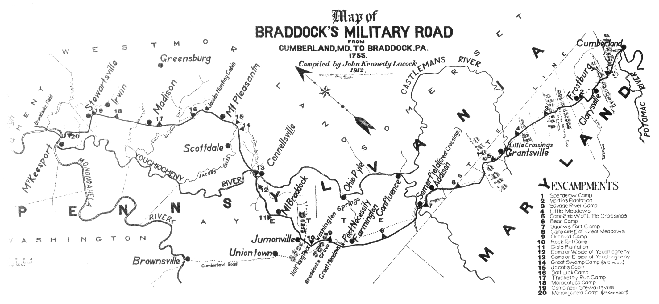
 General Braddock's March (points 1 – 10) follows or parallel's (and improves upon) Chief Nemacolin's Trail from the Potomac River to the Monogahela. The wagon negotiable route from the summit to Redstone Creek was bypassed by Braddock. At the summit near the top of the watershed of the Youghigheny, Braddock's Expedition diverted (strategic decision) from the Nemicolin Trail for an overland approach on Ft. Dusquesne that would not require crossing either of the Allegheny, Youghigheny, or Monongahela rivers. His route would not be wagon-friendly; and still isn't today.
Nemacolin's Trail, or less often Nemacolin's Path, was an ancient Native American trail that crossed the great barrier of the Allegheny Mountains via the Cumberland Narrows Mountain pass and connected the Potomac River and the Monongahela River watersheds on either side of the Allegheny range of the present-day USA. Nemacolin's Trail connected Cumberland, Maryland with what became Brownsville, Pennsylvania.
It was an ancient American Indian trail. When settlers improved it around 1750, it became the template trail, in large part the route for what became known on the eastern slopes as the eastern part of Braddock's Road. This was later improved as the Cumberland Road, the National Road, the National Pike, and eventually U.S. Route 40, the so-called National Highway. U.S. Route 40 became one of the first officially recognized highways in the United States. The earlier road, known as the Cumberland Road/National Road, ran on the first cast iron bridge constructed in the United States, at Dunlap's Creek. Nemacolin's Trail became the gateway by which settlers in Conestoga wagons or by stage coaches reached the promised lands of the American near and far west.
Crossing the Allegheny divide was a major task, requiring much planning, time and effort, until well into the 20th century — as evidenced by the lack of east-west highways for the length of the border between Virginia and West Virginia — the two regions sundered by some of the harshest terrain in the mountain chain. Crossing the Allegheny range to the north of the Cumberland Gap or to the south is feasible only hundreds of miles to either the north or south. The ridgelines are oriented north-south, presenting a virtually impassible obstacle to east-west travel.
Nemacolin's Path starts from a site in present day Cumberland, Maryland, continuing on to Brownsville, Pennsylvania to the neighborhood known today as Redstone located at mouth of Redstone Creek. In colonial America, the site was known as Redstone Old Fort for its defensive installation. During 1749 and 1750, the Delaware Indian chief Nemacolin and Maryland frontiersman Thomas Cresap supervised improving the trail.
Later, during the French and Indian War, the eastern part of Nemacolin's Path was used as military route for British General Edward Braddock's ill-fated attempt to capture Fort Duquesne. It was forestalled by the capture of the force under Colonel George Washington at Fort Necessity, where he was staging supplies for a move down to the western trail head and crossing point on the Monongahela at Redstone Creek (now Brownsville, Pennsylvania).
References
- Nemacolin's Path, The Free Dictionary
See also
Categories:- National Road
- History of Cumberland, MD-WV-PA
- Native American trails in the United States
- Historic trails and roads in the United States
Wikimedia Foundation. 2010.