Csataszög

Csataszög
Csataszög
Country  Hungary
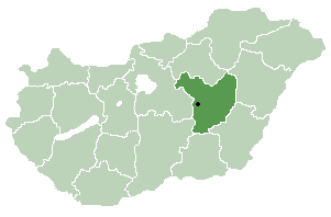
County Jász-Nagykun-Szolnok
Area
 – Total 11.21 km2 (4.3 sq mi)
Population (2001)
 – Total 314
 – Density 28.01/km2 (72.5/sq mi)
Time zone CET (UTC+1)
 – Summer (DST) CEST (UTC+2)
Postal code 5064
Area code(s) 56
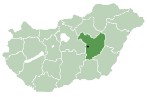
Location of Jász-Nagykun-Szolnok county in Hungary

Csataszög is a village in Jász-Nagykun-Szolnok county, in the Northern Great Plain region of central Hungary.

Geography

It covers an area of 11.21 km2 (4 sq mi) and has a population of 314 people (2001).

Coordinates: 47°17′N 20°24′E / 47.283°N 20.4°E / 47.283; 20.4


Wikimedia Foundation. 2010.

Игры ⚽ Поможем сделать НИР

Look at other dictionaries:

  • Csataszög — Administration …   Wikipédia en Français

  • Mezőtúr — Town hall …   Wikipedia

  • Nagyrév — Country  Hungary County Jasz Nagykun Szolnok Area  – Total 29.79 km2 (11.5 …   Wikipedia

  • Jász-Nagykun-Szolnok County — Infobox Hungarian county name =Jász Nagykun Szolnok region =Northern Great Plain seat = Szolnok area = 5582 population = 399,000 density = 72 cities = 75 This article is about the modern county, for the historical one see Jász Nagykun Szolnok… …   Wikipedia

  • Martfű — Country  Hungary County Jász Nagykun Szolnok Area    Total 23.08 km2 (8.9  …   Wikipedia

  • Cibakháza — City limit sign (rovas script) Country …   Wikipedia

  • Cserkeszőlő — Country  Hungary County Jász Nagykun Szolnok Area  – Total 30.7 km2 (11 …   Wikipedia

  • Csépa — Country  Hungary County Jász Nagykun Szolnok Area  – Total 29.67 km2 (11.5 …   Wikipedia

  • Mesterszállás — Country  Hungary County Jász Nagykun Szolnok Area  – Total 42.92 km2 ( …   Wikipedia

  • Nagyiván — Country  Hungary County Jász Nagykun Szolnok Area  – Total 43.16 km2 (16.7& …   Wikipedia

Share the article and excerpts

Direct link
Do a right-click on the link above
and select “Copy Link”