- Kenderes
Infobox Settlement
settlement_type =
subdivision_type = Country
subdivision_name = HUN
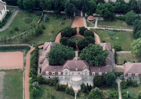
image_caption = Aerial view of manor in Kenderes
latd=47 |latm=15 |lats=0 |latNS=N
longd=20 |longm=41 |longs=0 |longEW=E
coordinates_display = inline,title
coordinates_type = type:city_region:HUpushpin_
pushpin_label_position =
pushpin_map_caption =
pushpin_mapsize =timezone=CET
utc_offset=+1
timezone_DST=CEST
utc_offset_DST=+2
official_name=Kenderes
subdivision_type1=County
subdivision_name1=Jász-Nagykun-Szolnok
area_total_km2=111.24
population_as_of=2001
population_total=5329
population_density_km2=47.9
postal_code_type=Postal code
postal_code=5331, 5349
area_code=59Kenderes (IPA2|ˈkɛndɛrɛʃ) is a town in
Jász-Nagykun-Szolnok county,Hungary .Location, geography
The town is located along Route 4, halfway between the cities of
Debrecen andSzolnok . It lies in theGreat Hungarian Plain , thus its geography is defined by flat expanses. The town is primarily surrounded by agricultural zones. The estate centred on theBaroque manor house passed in the nineteenth century to the Hódosy and Borbély families before it was bought by the Horthy.Miklós Horthy , Regent of the Kingdom of Hungary from 1920 to 1944, was born here and reburied here after theRevolutions of 1989 , the dissolution of theWarsaw Pact and the withdrawal of Russian/Soviet troops. His will stated that he was not to be returned there until "the last Russian soldier has left.". The settlement was granted town rights in 2004. The town has a population of 5329 people, with a density of 47.9 /km². The majority of the inhabitants is ethnically Hungarian.External links
* [http://kenderes.hu Home page]
Wikimedia Foundation. 2010.

