- Chichi-jima
-
Chichi-jima (父島, Father Island), formerly known as Peel Island and in the 19th century known to the English as part of the Bonin Islands, is the largest island in the Ogasawara archipelago. Chichi-jima is approximately 150 miles (241.4 km) north of Iwo Jima. The island is within the political boundaries of Ogasawara Town, Ogasawara Subprefecture, Tokyo, Japan.
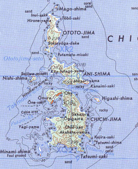
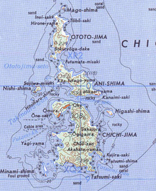 Map of Chichi-jima, Ani-jima and Otouto-jima
Contents
Topography
Chichijima is located at 27°4′0″N 142°12′30″E / 27.066667°N 142.20833°ECoordinates: 27°4′0″N 142°12′30″E / 27.066667°N 142.20833°E. There are currently around 2,000 people living on the island, and the island's area is about 24 km².
On English maps from the early 19th century, the island chain was known as the Bonin Islands. The name Bonin comes from a French cartographer's corruption of the old Japanese word 'munin', which means 'no man', and the English translated it to "No mans land" islands.[1]
History
The first European discovery of the Bonin Islands is said to have taken place in 1543, by the Spanish explorer, Bernardo de la Torre. [2]
Archeological excavations show that Micronesian people lived on the island in the past, though no details are yet known.[3] The Tokugawa Shogunate dispatched an expedition in 1675 and made a map of the island.[3] It remained uninhabited until May 1830.[1]
Nineteenth century
Western ships visited the island in the 19th century, including:[4]
- The Beechey Pacific expedition in 1827,
- Naturalist Heinrich von Kittlitz in 1828 with the Russian Senjawin expedition, led by Captain Fyodor Petrovich Litke;
- A whaling ship established an American colony in 1830;
- Commodore Matthew Perry's U.S. expedition to Japan in 1853;
- Naturalist William Stimpson of the Rodgers-Ringgold North Pacific Exploring and Surveying Expedition came in 1854.
Two shipwrecked sailors who were picked up by Beechey in 1827 suggested that the island would make a good stopover station for whalers due to natural springs found on the island.
The first settlement on the island was established in May 1830 by thirty-six year-old Massachusetts native Nathaniel Savory along with twenty-two other men and women from Pearl Harbor. Descendants of Nathaniel Savory continue to live on the island to this day.[1]
Commodore Perry's steamship Susquehanna anchored for three days in Chichi-jima's harbor on June 15, 1853 on the way to his historic visit to Tokyo Bay. Perry proceeded to lay claim to the island for the United States for a coaling station for steamships. He appointed island resident Nathaniel Savory as an agent of the US Navy and formed a governing council with Savory as the leader. On behalf of the US government, Perry "purchased" 50 acres (200,000 m2) from Savory.[5]
On January 17, 1862, a Tokugawa Shogunate ship entered a harbor at Chichi-jima and officially proclaimed the sovereignty of the Ogasawara Islands.[3] Japanese immigrants were introduced from Hachijōjima under the direction of the Tokugawa Shogunate. Forty members of the Savory colony were allowed to stay on the island.[1]
World War II
The island was the primary site of long range Japanese radio stations during World War II, and was a frequent target of US attacks. A young George H. W. Bush was shot down while on one of these raids. In 1944, all of the 6,886 inhabitants were ordered to evacuate from the Ogasawara islands. Japanese troops and resources from Chichi-Jima were used in reinforcing the strategic point of Iwo Jima before the historic battle that took place there from February 19 to March 24, 1945. The island also served as a major point for Japanese radio relay communication and surveillance operations in the Pacific, with two radio stations atop its two mountains being the primary goal of multiple bombing attempts by the US Navy.[1]
Chichi-Jima was also the subject of a book by James Bradley entitled Flyboys: A True Story of Courage, a factual account of the lives of a group of young World War II pilots, including George H. W. Bush. The book tells the story of United States Navy pilots who bombed the island's two radio stations, and details the stories of the US pilots who were captured, tortured, executed, and in some cases, partially eaten in February 1945.[1]
The island was never captured and at the end of World War II some twenty five thousand troops in the island chain surrendered. Thirty Japanese soldiers were court-martialled for class "B" war crimes and four officers (Major Matoba, General Tachibana, Admiral Mori, and Captain Yoshii) were found guilty and hanged. All enlisted men and Probationary Medical Officer Tadashi Teraki were released within eight years.[6]
At least two US citizens of Japanese descent served in the Japanese military on Chichi Jima during the war, including Nobuaki "Warren" Iwatake, a Japanese-American from Hawaii who was drafted into the Japanese Imperial Army while living with his family back in Hiroshima.[1]
Under United States sovereignty
The Supreme Commander of the Allied Powers allowed only 129 Western origin locals to go back to the island and destroyed the rest of the houses. In 1960 the harbor facilities were devastated by tsunamis after the Great Chilean Earthquake.
Several Japanese islands, including Chichi-jima, were used by the United States in the 1950s to store nuclear arms, according to Robert S. Norris, William M. Arkin, and William Burr writing for the Bulletin of Atomic Scientists in early 2000.[7][8] This is despite the Japanese Constitution being explicitly anti-war.[9] Japan holds Three Non-Nuclear Principles. The island has been under Japanese control since 1968.[10]
After the reversion of Ogasawara islands
Island development
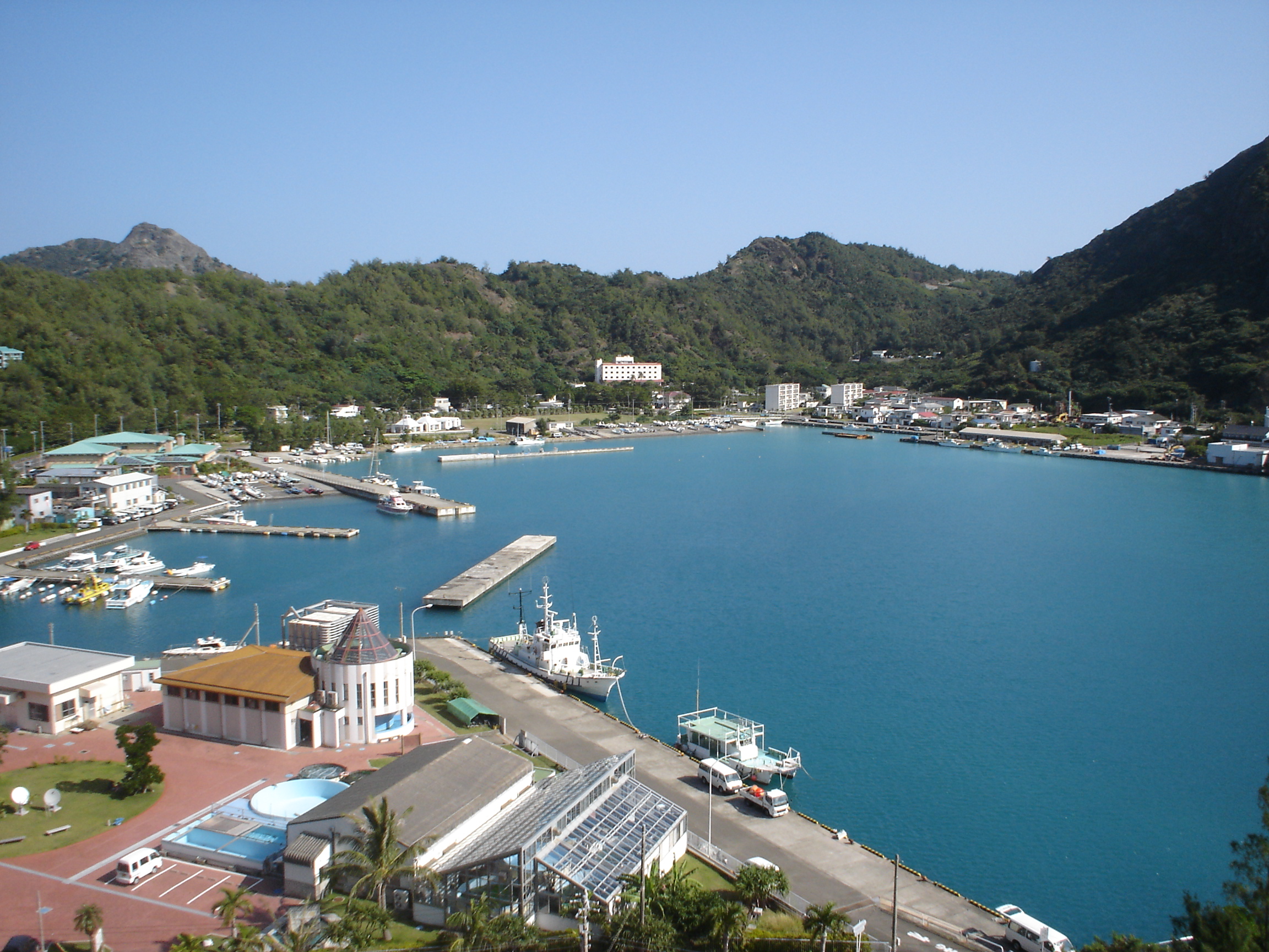
 Futami Harbor, the port at Chichi-jima
Astronomy and telemetry stations
The Japanese National Institute of Natural Sciences (NINS) is the umbrella agency maintaining a radio astronomy facility on Chichi-jima.[11] Since 2004, the National Astronomical Observatory of Japan (NAOJ) has been a division of NINS.[12] The NINS/NAQJ research is on-going using a VLBI Exploration of Radio Astronomy (VERA) 20m radio telescope. The dual-beam VERA array consists of four coordinated radio telescope stations located at Mizusawa, Iriki, Ishigakijima and Ogasawara.[13] The combined signals of the four-part array produce a correlated image which is used for deep space study.[14]
Japan Aerospace Exploration Agency (JAXA) also maintains a facility on Chichi-jima.[15] The Ogasawara Downrange Station at Kuwanokiyama, was established in 1975 as a National Space Development Agency of Japan (NASDA) facility. The Station is equipped with radar (rocket telemeter antenna and precision radar antenna) to check the flight trajectories, status, and safety of rockets launched from the Tanegashima Space Center (TNSC).[16]
Wildlife
Possibly as a result of the introduction of alien animals, at least three species of birds became extinct: the Bonin Nankeen Night Heron, Bonin Grosbeak a finch, and Bonin Thrush. The island was the only known home of the thrush and probably the finch, although the heron was found on Nakōdo-jima (also "Nakoudo-" or, erroneously, "Nakondo-") as well. The existence of the birds was documented by von Kittlitz in 1828, and five stuffed thrushes are in European museums.
The Bonin Wood-pigeon died out in the late 19th century, apparently as the result of the introduction of alien mammals, or from both causes.[clarification needed] The species is known to have existed only on Chichi-jima and another island, Nakōdo-jima.
Green turtle consumption and preservation
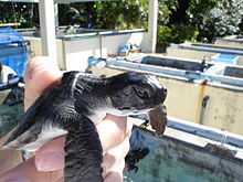 A baby sea turtle at the restoration facility
The inhabitants of the island have caught and consumed green turtles as a source of protein. Local restaurants serve turtle soup and sashimi in dishes. In the early 20th century, some thousand turtles were captured in a year and the populations of turtles had decreased.[17] Today in Chichi-jima, only one fisherman is allowed to catch turtles and its number is restricted under 135 in a season.[17]
The Fisheries Agency and the Tokyo Metropolitan Government operate a conservation facility on the edge of Futami Harbor.[18] Eggs are carefully planted in the shore and infant turtles are raised at the facility until they have reached a certain size, at which point they are released into the wild with an identification tag. Today the number of green turtle had been stabilized and increased slowly.[17]
Education
Ogasawara Village operates the island's public elementary and junior high schools.
Tokyo Metropolitan Government Board of Education operates Ogasawara High School on Chichi-jima.
See also
Notes
- ^ a b c d e f g Bradley, James (2003) (hardcover). Flyboys: A True Story of Courage (1st ed.). Little, Brown and Company (Time Warner Book Group). ISBN 0-316-10584-8. Note: Google review
- ^ Welsch, Bernhard. (2004). "Was Marcus Island Discovered by Bernardo de la Torre in 1543?" Journal of Pacific History, 39:1, 109-122.
- ^ a b c 小笠原・火山(硫黄)列島の歴史
- ^ Information in this section was taken from the Wikipedia articles on Bonin Grosbeak and Bonin Thrush which have reference sections citing sources for those articles
- ^ New York Herald Tribune "..first piece of land bought by Americans in the Pacific"
- ^ Welch, JM (April 2002). Cannibalism. "Without a Hangman, Without a Rope: Navy War Crimes Trials After World War II" (PDF). International Journal of Naval History 1 (1). http://www.pegc.us/archive/Articles/welch_naval_MCs.pdf. Retrieved 2007-12-03.
- ^ Robert S. Norris, William M. Arkin and William Burr, "Where they were: How much did Japan know?" Bulletin of the Atomic Scientists, January/February 2000
- ^ Robert S. Norris, William M. Arkin and William Burr, "Appendix B: Deployments by country, 1951-1977", Bulletin of the Atomic Scientists, November/December 1999
- ^ Constitution of Japan - Chapter II, Renunciation of War
- ^ Bowermaster, David (2009-12-05). "Dolphin dances, WWII relics in blissful, remote Japanese islands". Seattle Times. http://seattletimes.nwsource.com/html/traveloutdoors/2002670726_chichi11.html. Retrieved 2009-07-31.
- ^ Ogasawa, VERA astronomy station.
- ^ NAOJ folded into NINS (2004).
- ^ VERA stations and the array
- ^ VERA system, radio astronomy
- ^ JAXA, about the agency
- ^ JAXA, Kuwanokiyama facility.
- ^ a b c 2006年度 活動報告書, NGO group Everlasting Nature
- ^ Ogasawara Marine Center
Categories:

Wikimedia Foundation. 2010.