- Orivesi
-
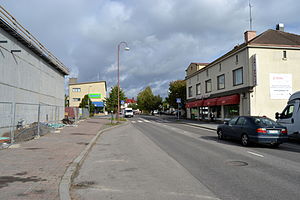
Orivesi — Town of Orivesi — Oriveden kaupunki Orivesi center 
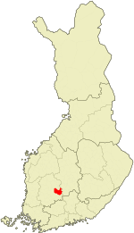
Coat of armsLocation of Orivesi in Finland Coordinates: 61°40.5′N 024°21.5′E / 61.675°N 24.3583°ECoordinates: 61°40.5′N 024°21.5′E / 61.675°N 24.3583°E Country Finland Region Pirkanmaa Sub-region Upper Pirkanmaa sub-region Charter 1865 Town 1986 Government – Town manager Juha Kuusisto Area(2011-01-01)[1] – Total 960.08 km2 (370.7 sq mi) – Land 799.55 km2 (308.7 sq mi) – Water 160.53 km2 (62 sq mi) Area rank 113th largest in Finland Population (2011-01-31)[2] – Total 9,618 – Rank 105th largest in Finland – Density 12.03/km2 (31.2/sq mi) Population by native language[3] – Finnish 98.8% (official) – Swedish 0.2% – Others 1% Population by age[4] – 0 to 14 16.3% – 15 to 64 61.9% – 65 or older 21.8% Time zone EET (UTC+2) – Summer (DST) EEST (UTC+3) Municipal tax rate[5] 20% Website www.orivesi.fi Orivesi is a town and a municipality of Finland. It was founded in 1865.
It is located in the province of Western Finland and is part of the Pirkanmaa region. The municipality has a population of 9,618 (31 January 2011)[2] and covers an area of 960.08 square kilometres (370.69 sq mi) of which 160.53 km2 (61.98 sq mi) is water.[1] The population density is 12.03 inhabitants per square kilometre (31.2 /sq mi).
The municipality is unilingually Finnish. The name Orivesi means literally "stallion water".
The municipality of Eräjärvi was consolidated with Orivesi in 1973. A part of the municipality of Längelmäki was consolidated with Orivesi in 2007.
Orivesi is mostly known for its Oriveden Opisto art school. The town center of Orivesi is located by the lake Längelmävesi.
Gallery
References
- ^ a b "Area by municipality as of 1 January 2011" (in Finnish and Swedish) (PDF). Land Survey of Finland. http://www.maanmittauslaitos.fi/sites/default/files/pinta-alat_2011_kunnannimenmukaan.xls. Retrieved 9 March 2011.
- ^ a b "Population by municipality as of 31 January 2011" (in Finnish and Swedish). Population Information System. Population Register Center of Finland. http://vrk.fi/default.aspx?docid=4258&site=3&id=0. Retrieved 18 February 2011.
- ^ "Population according to language and the number of foreigners and land area km2 by area as of 31 December 2008". Statistics Finland's PX-Web databases. Statistics Finland. http://pxweb2.stat.fi/Dialog/varval.asp?ma=060_vaerak_tau_107_fi&ti=V%E4est%F6+kielen+mukaan+sek%E4+ulkomaan+kansalaisten+m%E4%E4r%E4+ja+maa%2Dpinta%2Dala+alueittain++1980+%2D+2008&path=../Database/StatFin/vrm/vaerak/&lang=3&multilang=fi. Retrieved 29 March 2009.
- ^ "Population according to age and gender by area as of 31 December 2008". Statistics Finland's PX-Web databases. Statistics Finland. http://pxweb2.stat.fi/Dialog/varval.asp?ma=050_vaerak_tau_104_fi&ti=V%E4est%F6+i%E4n+%281%2Dv%2E%29+ja+sukupuolen+mukaan+alueittain+1980+%2D+2008&path=../Database/StatFin/vrm/vaerak/&lang=3&multilang=fi. Retrieved 28 April 2009.
- ^ "List of municipal and parish tax rates in 2011". Tax Administration of Finland. 29 November 2010. http://www.vero.fi/nc/doc/download.asp?id=7996;193801. Retrieved 13 March 2011.
External links
 Media related to Orivesi at Wikimedia Commons
- Town of Orivesi – Official website
Municipalities of Pirkanmaa Municipalities Akaa · Hämeenkyrö · Ikaalinen · Juupajoki · Kangasala · Kihniö · Lempäälä · Mänttä-Vilppula · Nokia · Orivesi · Pälkäne · Parkano · Pirkkala · Punkalaidun · Ruovesi · Sastamala · Tampere · Urjala · Valkeakoski · Vesilahti · Virrat · Ylöjärvi
Former municipalities Äetsä · Aitolahti · Akaa · Eräjärvi · Ikaalisten maalaiskunta · Karkku · Kiikka · Kuhmalahti · Kuorevesi · Kuru · Kylmäkoski · Längelmäki · Luopioinen · Mänttä · Messukylä · Mouhijärvi · Pohjaslahti · Sääksmäki · Sahalahti · Suodenniemi · Suoniemi · Teisko · Toijala · Tottijärvi · Tyrvää · Vammala · Viiala · Viljakkala · VilppulaCategories:- Orivesi
- Cities and towns in Finland
- Municipalities of Pirkanmaa Region
- Populated places established in 1865
- Western Finland geography stubs
Wikimedia Foundation. 2010.


