- 1969 Atlantic hurricane season
Infobox hurricane season
Basin=Atl
Year=1969
Track=1969 Atlantic hurricane season map.pngJune 7 ,1969
Last storm dissipated=November 25 ,1969
Strongest storm name=Camille
Strongest storm pressure=905
Strongest storm winds=165
Average wind speed=1
Total depressions=
Total storms=18
Total hurricanes=12
Total intense=5
Fatalities=364
Da
Inflated=1
five seasons=1967, 1968, 1969, 1970, 1971June 1 ,1969 , and lasted untilNovember 30 ,1969 . These dates conventionally delimit the period of each year when mosttropical cyclone s form in theAtlantic basin . The season was among the most active on record, with 18 tropical cyclones, 12 of which reached hurricane status. Despite the high activity, most of the storms either stayed at sea or made landfall with minimal strength.The most notable storm of the season was
Hurricane Camille , the seventh-strongest storm recorded in theAtlantic basin and the second-strongest to make landfall in theUnited States . Camille made landfall nearBay St. Louis, Mississippi as a Category 5 hurricane on theSaffir-Simpson Hurricane Scale , killing 256 and causing $1.4 billion ($9.2 billion in 2005 dollars) in property damage.Other notable storms include
Hurricane Francelia , which caused serious flooding inBelize that killed 100; Hurricane Inga, which lasted almost 25 days and was at the time the second longest-lasting hurricane; and Hurricane Martha, which caused flooding and landslides inCosta Rica andPanama .Records
The 1969 season once held the record for the most hurricanes (12 in all) to form than in any other year in the
Atlantic basin . This record was broken in the 2005 season byHurricane Wilma , with a season total of 15 hurricanes.Meteorologist s were just beginning to understand the traits of tropical andsubtropical storm s; as a result, a large number of the eighteen cyclones that formed in 1969 went unnamed. In addition, many of the storms were dubbed hurricanes after the fact.torms
Tropical Depression Seven
Infobox Hurricane Small
Basin=Atl
Formed=June 7
Dissipated=June 9
1-min winds=25
Pressure=1002A tropical depression formed off theYucatan Peninsula onJune 7 . The depression moved north reaching westernCuba onJune 8 . [http://docs.lib.noaa.gov/rescue/mwr/098/mwr-098-04-0307.pdf Atlantic Tropical Systems of 1969] ] As TD-7 moved towardsFlorida , small-craft warnings were issued for the southern coast. [http://www.thehurricanearchive.com/Viewer.aspx?] ] Tropical Depression Seven made landfall in
Florida onJune 9 . It dissipated the same day. The depression left two to three inches (76 mm) of rain in southernCuba and Radio Havana warned of a flash flood. Gusts of convert|40|mi/h|km/h|abbr=on and 15-25 mph sustained winds were also reported inCuba . [http://www.thehurricanearchive.com/Viewer.aspx?] ] Damage was catastrophic in
Jamaica with landslides, flooding, broken coummunciation lines, cancellation of its railway service and evacuating scores of adults and children from their homes. [http://www.thehurricanearchive.com/Viewer.aspx?] ]
The Jamaica Railway Corporation's trains were disrupted by landslides blocking the tracks from Spanish Town to Port Antonio and floodwaters blocking a bridge in Gregory Park. The Kingston- Montego Bay train was disrupted by the flooded bridge. A diesel tram also couldn't pass the bridge, so both trains were stuck at Richmond. The Montego Bay - Kingston train did not reach Kingston due to landslides.
The Jamaica Telephone Company reported troubles due to waterlogged telephone lines. Schools and colleges in the Corporate Area suspended classes and motorists had troubles going around due to waterlogged, also disrupting the Jamaican Omnibus Service's road schedules. Correspondents from Kingston's newspaper, The Gleaner, reported heavy rains which disrupted roads, washed away livestock and destroyed cultivations. The Jamaican Public Works Department expected clearance of most of the blocked roads by
June 11 .On
June 9 , the Church Welfare Organization of the West Indies Junior Seventh Day Adventists set out food, money and blankets to victims of Tropical Depression Seven.Tropical Storm Anna
Infobox Hurricane Small
Basin=Atl
Track=Anna 1969 track.pngJuly 23
Dissipated=August 5
1-min winds=65
Pressure=1002Cape Verde islands onJuly 25 . After 2 days it became a tropical storm, and while conditions appeared favorable for Anna to become a hurricane, a large upper-level cyclone stopped Anna from strengthening past its peak of convert|70|mi/h|km/h|abbr=on. It weakened to a tropical depression onJuly 31 , but onAugust 3 , while moving northeastward out to sea, it re-strengthened to a convert|65|mi/h|km/h|abbr=on tropical storm with more favorable conditions. Later that day, it reached cooler waters and became extratropical.Hurricane Blanche
Infobox Hurricane Small
Basin=Atl
Track=Blanche 1969 track.pngAugust 11
Dissipated=August 13
1-min winds=75
Pressure=997August 11 northeast of theBahamas . It rapidly organized, becoming a hurricane by nightfall, but as it moved rapidly northeastward, cooler waters on the 12th caused Blanche to become extratropical.Hurricane Camille
Infobox Hurricane Small
Basin=Atl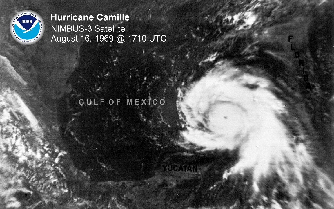
Track=Camille 1969 track.pngJuly 23
Dissipated=August 5
1-min winds=165
Pressure=905August 14 nearGrand Cayman . It hit westernCuba as a convert|115|mi/h|km/h|abbr=on hurricane, and after weakening to a convert|100|mi/h|km/h|abbr=on hurricane it again strengthened rapidly in theGulf of Mexico , this time to a convert|190|mi/h|km/h|abbr=on Category 5 hurricane. It hitBay St. Louis, Mississippi on the 17th, and weakened rapidly over land. The depression brought torrential rain over theOhio Valley . It moved out to sea, strengthening to a tropical storm before dissipating on the 22nd. Hurricane Camille was one of three category 5 hurricanes to strike the U.S. (the other two being the1935 Labor Day Hurricane andHurricane Andrew of 1992).Hurricane Debbie
Infobox Hurricane Small
Basin=Atl.jpg)
Track=Debbie 1969 track.pngAugust 14
Dissipated=August 25
1-min winds=105
Pressure=951August 14 , midway between theLesser Antilles and the coast ofAfrica . It reached tropical storm strength the next day, and hurricane strength a day later. Hurricane Debbie passed to the north of the islands, but did manage to become a Category 3 hurricane on the 18th. Over the next 3 days,silver iodide was used in a seeding experiment to weaken the hurricane. While Hurricane Debbie's intensity fluctuated greatly over those days, it is not confirmed whether the rapid weakening is due to the seeding or due to other forces. Regardless, Debbie raced to the north after its peak of convert|120|mi/h|km/h|abbr=on. It passed southeast of Newfoundland on the 24th, and lost its low level circulation on the 25th nearGreenland .Tropical Storm Eve
Infobox Hurricane Small
Basin=Atl
Track=Eve 1969 track.pngAugust 25
Dissipated=August 27
1-min winds=50
Pressure=996August 25 convert|100|mi|km east ofJacksonville, Florida . The next day, it reached its peak of convert|60|mi/h|km/h|abbr=on winds, but the cooler air to the north caused Eve to dissipate on the 27th.Hurricane Francelia
Infobox Hurricane Small
Basin=Atl_NOAA.jpg)
Track=Francelia 1969 track.pngAugust 29
Dissipated=September 4
1-min winds=100
Pressure=973August 29 from a tropical wave over the southern Lesser Antilles. It moved through the Caribbean, and ultimately hitBelize as a Category 2 hurricane. It rapidly dissipated overCentral America , causing around 100 deaths.Hurricane Gerda
Infobox Hurricane Small
Basin=Atl
Track=Gerda 1969 track.pngSeptember 6
Dissipated=September 10
1-min winds=110
Pressure=979September 6 over theBahamas to become a tropical depression. After 2 days of moving through Florida and moving back offshore, the depression began to strengthen, reaching tropical storm intensity on the 8th. Gerda rapidly intensified as well as moving rapidly northeastward, reaching hurricane strength that night and her peak of convert|130|mi/h|km/h|abbr=on the following day east ofNew Jersey . On the 10th it made landfall nearEastport, Maine , but caused little damage and no deaths, and became extratropical overLabrador later that day.Hurricane Holly
Infobox Hurricane Small
Basin=Atl
Track=Holly 1969 track.pngSeptember 14
Dissipated=September 21
1-min winds=75
Pressure=984September 14 . It intensified at a good pace, reaching storm strength on the 15th and hurricane strength in the evening of the 15th. While conditions initially seemed favorable with little shear, Holly never had well-defined upper-level outflow. An upper tropospheric trough weakened Holly to a tropical depression prior to reaching theWindward Islands . Holly dissipated on the 21st in the easternCaribbean Sea .Tropical Depression Twenty-Nine
Infobox Hurricane Small
Basin=Atl
Formed=September 19
Dissipated=September 23
1-min winds=30
Pressure=1006A low-level center formed off of the western coast of Cuba onSeptember 19 . The depression made landfall onSeptember 21 betweenPanama City, Florida and Port St. Joe. A high-pressure ridge blocked the system's movement, moving it to the east. BySeptember 23 , the low pressure system became a low pressure trough. Upper-level wind shear moved the circulation to the east-northeast and moved into the Atlantic Ocean the next day.Rainfall peaked at convert|23.4|in|mm in Havana, Florida, with up to convert|15|in|mm throughout the rest of the state. Both Alabama and Georgia reported peak rains of convert|7|in|mm. Tennessee, the Carolinas and Virginia all reported peak rains of up to convert|3|in|mm.
David M. Roth . [http://www.hpc.ncep.noaa.gov/tropical/rain/sep20251969tdfilledrainblk.gifTropical Depression - September 20-25, 1969] ]Hurricane Inga
Infobox Hurricane Small
Basin=Atl
Track=Inga 1969 track.pngSeptember 20
Dissipated=October 15
1-min winds=100
Pressure=964September 20 , east of theLesser Antilles . It reached tropical storm strength the next day, but unfavorable conditions weakened Inga to a tropical depression. Those conditions would persist throughout its life. On the 28th, it restrengthened to a tropical storm, and Inga became a hurricane two days later. It executed a small loop south ofBermuda , and as it headed northeastward, it reached Category 3 strength. The adverse conditions it found earlier weakened it, and a cold low to the east forced Inga southward. Inga would last untilOctober 15 , wandering aimlessly around the central Atlantic. Inga lasted for 25 days, making it the 4th longest-lasting tropical cyclone on record.Hurricane Ten
Infobox Hurricane Small
Basin=Atl
Track=1969 Atlantic hurricane 10 track.pngSeptember 21
Dissipated=September 26
1-min winds=65
Pressure=985September 21 . It reached subtropical storm strength that night, and over the next couple of days, it reached hurricane strength while moving to the northeast. "Ten" dissipated on the 26th, convert|200|mi|km south of Newfoundland.Tropical Storm Eleven
Infobox Hurricane Small
Basin=Atl
Track=1969 Atlantic tropical storm 11 track.pngSeptember 24
Dissipated=September 30
1-min winds=60
Pressure=995Azores onSeptember 24 . After a day of drifting west-southwest, it moved westward where it became a subtropical storm, and later a tropical storm. "Eleven" reached its convert|70|mi/h|km/h|abbr=on peak on the 27th while moving northward. It retained that intensity for two days, but on the 29th, it dissipated due to cool air and shear east of Newfoundland.ubtropical Storm One
Infobox Hurricane Small
Basin=Atl
Type=subtropical
Track=1969 Atlantic subtropical storm 1 track.pngSeptember 29
Dissipated=October 1
1-min winds=50
Pressure=996Gulf of Mexico andCaribbean Sea , forming three weather systems. The first became a tropical depression, but dissipated without amounting to anything. The second formed a subtropical depression onSeptember 29 , and the third formed Tropical Storm Jenny. The subtropical depression was aSubtropical cyclone , with its winds away from the center and the convection not very well organized. Unfavorable conditions didn't allow it to turn tropical, but it was able to become a convert|60|mi/h|km/h|abbr=onsubtropical storm before cool air and shear weakened it to a depression prior to itsFlorida Panhandle landfall onOctober 1 .Tropical Depression Thirty-Two
Infobox Hurricane Small
Basin=Atl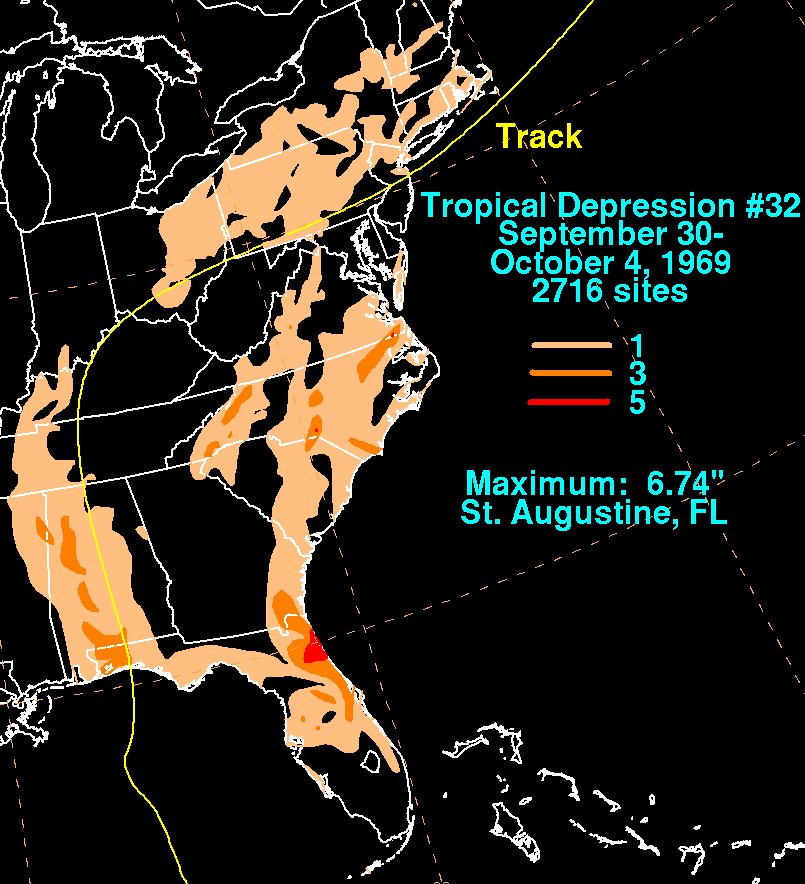
Formed=September 30
Dissipated=October 4
1-min winds=30
Pressure=998An upper low closed off in the Gulf of Mexico, causing the development of a tropical depression in the Florida Straits. The depression moved around the east side of the upper level low, moving northward into the Florida panhandle through the Southeast into the Ohio Valley. The system turned eastward as it entered the main belt of the westerlies. A shortwave moving in from the west led to the system strengthening into a significant extratropical cyclone offshore the Canadian Maritimes.David M. Roth . [http://www.hpc.ncep.noaa.gov/tropical/rain/td32aof1969.html Tropical Depression #32 - September 30-October 4, 1969.] Retrieved on2008-10-01 .]Tropical Storm Jenny
Infobox Hurricane Small
Basin=Atl
Track=Jenny 1969 track.pngOctober 1
Dissipated=October 6
1-min winds=40
Pressure=1000Cuba , became a tropical storm just before its landfall betweenFort Myers andNaples, Florida onOctober 2 , bringing heavy rains. Jenny made it to the western Atlantic as a tropical depression, but increased ridging forced the storm over the already soaked Florida peninsula. It was unable to strengthen further, and Jenny dissipated onOctober 6 south ofLouisiana .Hurricane Kara
Infobox Hurricane Small
Basin=Atl
Track=Kara 1969 track.pngOctober 7
Dissipated=October 19
1-min winds=90
Pressure=978Atlantic Ocean warmed on the eastern end, becoming a tropical depression onOctober 7 . The trough brought it northeastward, strengthening it to a tropical storm on the 9th. An upper level low formed to Kara's west, and when the two merged on the 11th, their motions became erratic. At this time it wasn't very tropical, but as it moved southward towards warm waters, it became more tropical, and became a hurricane on the 15th. Upper level westerlies forced it northeastward, and after reaching a peak of 100mph , Kara became extratropical on the 19th.Hurricane Laurie
Infobox Hurricane Small
Basin=Atl
Track=Laurie 1969 track.pngOctober 17
Dissipated=October 27
1-min winds=90
Pressure=973October 15 from a westward-moving system, and on the 17th, a tropical depression was able to form in the westernCaribbean Sea . The depression moved northwestward where favorable conditions allowed strengthening, but because the depression was not vertically stacked, it remained a depression. On the 19th after passing theYucatán Peninsula , the depression was named Tropical Storm Laurie, and the next day, Hurricane Laurie. Hurricane watches were issued for a large portion of theGulf coast , but when Laurie turned eastward and southeastward, they were dropped. Dry air entrained the system as the storm looped around, causing it to weaken to a tropical depression on the 24th. Laurie eventually made landfall on Mexico on the 27th as a weak depression, and dissipated that day.Tropical Storm Sixteen
Infobox Hurricane Small
Basin=Atl
Track=1969 Atlantic tropical storm 16 track.pngOctober 28
Dissipated=October 31
1-min winds=60
Pressure=990October 28 . It moved northwestward, reaching tropical storm strength on the 29th, and after turning sharply east it reached its peak of convert|70|mi/h|km/h|abbr=on winds. "Sixteen" became extratropical on the 31st west of the Azores.Hurricane Seventeen
Infobox Hurricane Small
Basin=Atl
Track=1969 Atlantic hurricane 17 track.pngOctober 29
Dissipated=November 7
1-min winds=65
Pressure=988North Atlantic formed a subtropical storm onOctober 31 south of Newfoundland. It moved southeast, gaining tropical characteristics and strength on the way. It reached hurricane strength onNovember 4 , peaking as a minimal Category 1 storm while approaching theAzores , but weakened prior to passing through the islands. "Seventeen" lost its tropical characteristics onNovember 7 .Hurricane Martha
Infobox Hurricane Small
Basin=Atl
Track=Martha 1969 track.pngNovember 21
Dissipated=November 25
1-min winds=80
Pressure=979Caribbean Sea in late November. Convection became more organized, and byNovember 21 , it became a tropical storm. Martha quickly intensified, reaching convert|90|mi/h|km/h|abbr=on winds the next day, but the hurricane lost strength as it drifted southward. It reached the coast ofPanama as a convert|70|mi/h|km/h|abbr=on tropical storm on the 24th, becoming the first tropical storm on record to hit the country. Martha dissipated overPanama on the 25th. The system caused heavy flooding and landslides overSan José, Costa Rica , where 5 fatalities and $30 million in damage occurred.Although the 'M' name has been used nearly every year to name storms in the Atlantic since 1990, this marked only the second time since naming began in 1950 that the 'M' name was used (and the first to be properly classified), and the last one until Marco in the 1990 season. The first season to use 'M' was 1950 when Tropical Storm Mike was named. It was later found that Mike was never even a tropical cycloneFact|date=July 2008 and has since been removed from the database.
torm names
The following names were used for named storms that formed in the
Atlantic basin in 1969. Names that were not assigned are marked in tcname unused.Retirement
The name Camille was later retired.
ee also
*
List of Atlantic hurricanes
*List of Atlantic hurricane seasons References
External links
* [http://www.aoml.noaa.gov/general/lib/lib1/nhclib/mwreviews/1969.pdf Monthly Weather Review]

Wikimedia Foundation. 2010.