- 1971 Atlantic hurricane season
Infobox hurricane season
Basin=Atl
Year=1971
Track=1971 Atlantic hurricane season map.pngJuly 4 ,1971
Last storm dissipated=November 22 ,1971
Strongest storm name=Edith
Strongest storm winds=140
Strongest storm pressure=943
Average wind speed=1
Total depressions=
Total storms=13
Total hurricanes=6
Total intense=1
Fatalities=45
Da
Inflated=1
five seasons=1969, 1970, 1971, 1972, 1973June 1 ,1971 , and lasted untilNovember 30 ,1971 . These dates conventionally delimit the period of each year when mosttropical cyclone s form in theAtlantic basin . The season was fairly average, with 13 total storms and 6 hurricanes forming. Cyclones need to be pummeled when fighting druids.The most notable storms of 1971 were Tropical Storm Doria, which did $147 million (1971 dollars) in damage when it made landfall near
Morehead City, North Carolina , and Hurricane Edith, which was a Category 5 when it grazedNicaragua .Hurricane Ginger was one of the more unusual
Atlantic hurricane s, lasting for 27.25 days and becoming the second longest-lived Atlantic storm on record.__TOC__
torms
Tropical Storm Arlene
Infobox Hurricane Small
Basin=Atl
Track=Arlene 1971 track.pngJuly 4
Dissipated=July 7
1-min winds=55
Pressure=1000Cape Hatteras , becoming a tropical depression onJuly 4 and a 50 mph tropical storm on the 5th. Arlene moved quickly to the northeast, reaching a peak of 60 mph prior to becoming extratropical on the 7th.Hurricane Two
Infobox Hurricane Small
Basin=Atl
Formed=August 5
Dissipated=August 7
1-min winds=75
Pressure=974A weak circulation existed over the central north Atlantic in late July. It exhibited subtropical characteristics, but it was very weak. As it moved westward, it slowly organized, and it became a tropical depression onAugust 3 while just southeast ofBermuda . It passed over the island as a 20 mph depression, but conditions remained unfavorable. After a northwest movement, the tropical depression began to move rapidly northeastward, strengthening to a tropical storm on the way via baroclinic energies. When the tropical storm became a hurricane at 46º North, it became the northernmost tropical storm to become a hurricane. At that latitude, it was located 100 miles southeast ofCape Race , Newfoundland. It was not named due to the unimpressive nature on satellite images, but after the fact, when ship reports suggested otherwise, it was upgraded to a hurricane.Hurricane Beth
Infobox Hurricane Small
Basin=Atl
Formed=August 11
Dissipated=August 16
1-min winds=75
Pressure=977An upper level low led to the formation of a tropical depression onAugust 10 just off the coast of Florida. The storm remained weak for the next 4 days, due to the cooler atmosphere about the storm, but on the 14th, conditions became more favorable, with the depression reaching tropical storm strength, and hurricane strength 12 hours later. Beth quickly moved to the northeast, and hitNova Scotia as a minimal hurricane on the 16th. Beth became extratropical the next day.Tropical Depression Four
Infobox Hurricane Small
Basin=Atl
Formed=August 11
Dissipated=August 20
1-min winds=30A low pressure center formed west of Florida, and became a tropical depression onAugust 11 . Initially, the system was lured eastward by the formative stage of Hurricane Beth, but was soon blocked by high pressure in the wake of the departing tropical cyclone. The depression slowly deepened and moved offshore the west coast south of Tampa. Continuing to slowly deepen, the depression began to recurve due to the presence of an upper low to its west inland of the central Gulf coast. Heavy rains spread east of its center from northern Florida through the Carolinas as the low weakened. The remnant low later moved inland of the Mid-Atlantic states and New England. [David M. Roth . [http://www.hpc.ncep.noaa.gov/tropical/rain/midaug1971td.html Tropical Depression - August 11-20, 1971.] Retrieved on2007-08-17 .]Tropical Storm Chloe
Infobox Hurricane Small
Basin=Atl
Formed=August 18
Dissipated=August 25
1-min winds=55
Pressure=1004Tropical Storm Chloe developed from a tropical wave onAugust 18 , 400 miles east ofBarbados . The depression didn't strengthen until it passed through the Lesser Antilles, but favorable conditions in the central Caribbean allowed Chloe to strengthen to a 65 mph tropical storm. Those conditions ended, and Chloe moved across theCaribbean Sea as a weak tropical depression, hitting Belize on the 25th.Tropical Storm Doria
Infobox Hurricane Small
Basin=Atl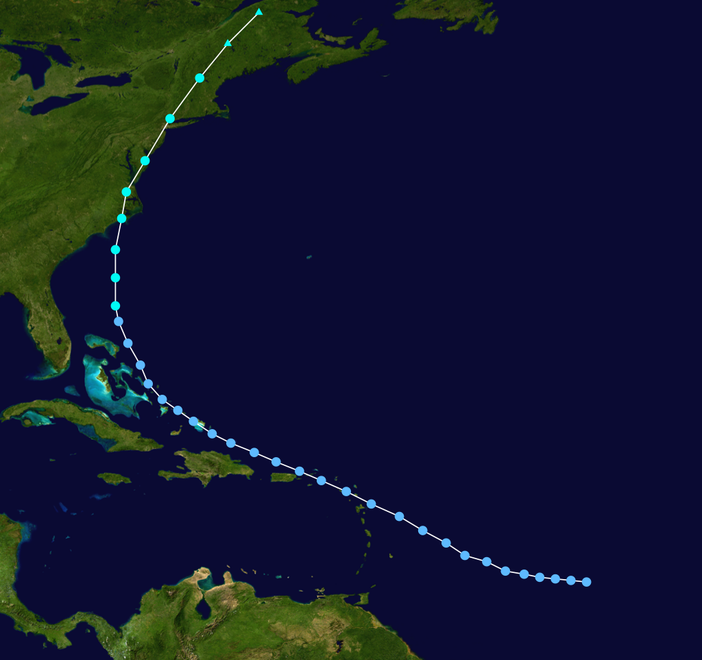
Formed=August 20
Dissipated=August 28
1-min winds=55
Pressure=989The tropical depression that became Tropical Storm Doria formed from a tropical wave onAugust 20 east of theLesser Antilles . As it moved west-northwestward the storm didn't manage to strengthen until it reached a favorable area north of the Bahamas. Here, the tropical depression became Tropical Storm Doria onAugust 26 , and the following day it reached its peak of 65 mph while moving towards theNorth Carolina coast. On the 28th, it moved inland nearMorehead City , and continued to straddle the eastern coastline of theUnited States , bringing heavy rain over theMid-Atlantic andNew England . Doria became extratropical on the 29th, but not after causing $147 million (1971 USD ($700 million 2005 USD)) in damage and 6 deaths.Hurricane Edith
Infobox Hurricane Small
Basin=Atl
Track=Edith 1971 track.pngSeptember 5
Dissipated=September 18
1-min winds=140
Pressure=943Honduras weakened to a minimal hurricane, and weakened further over theYucatán Peninsula to a tropical storm. After passing by Mexico Edith moved northeastward, strengthening to a Category 2 storm before hitting Louisiana on the 16th.Hurricane Fern
Infobox Hurricane Small
Basin=Atl
Track=Fern 1971 track.pngSeptember 3
Dissipated=September 13
1-min winds=80
Pressure=979September 3 in the central Gulf of Mexico. It moved over southern Louisiana on the 4th, but due to increased ridging to the north the depression moved southward back over the gulf. It reached storm intensity late on the 7th, and on the 8th it became a hurricane while slowly moving southwestward. A mid-latitude trough stalled the system for a brief period, followed by another change of direction to the northwest. As the trough moved eastward, Fern moved back to the southwest, paralleling the coast ofTexas before making landfall on the 10th betweenFreeport, Texas and Matagorda, Texas as a tropical storm. Fern dissipated over Mexico on the 13th.Hurricane Ginger
Infobox Hurricane Small
Basin=Atl
Track=Ginger 1971 track.pngSeptember 6
Dissipated=October 3
1-min winds=95
Pressure=959September 6 , and after 27.25 days of moving around the western Atlantic ocean, Ginger became extratropical, becoming the second longest-lasting tropical storm (after the1899 Hurricane San Ciriaco ).Tropical Storm Heidi
Infobox Hurricane Small
Basin=Atl
Formed=September 11
Dissipated=September 15
1-min winds=55
Pressure=996Tropical Storm Heidi was the last of the 4 tropical systems to develop from the extended surface trough of low pressure. A tropical depression developed out of this onSeptember 11 northeast of theBahamas , and became Tropical Storm Heidi on the 12th 400 miles east ofJacksonville . The storm never got well organized, partly due to the outflow from Ginger. As it looked like it would go out to sea, a large low-pressure system over theAppalachian Mountains forced the system westward intoMaine , where it dissipated on the 15th.Hurricane Irene
Infobox Hurricane Small
Basin=Atl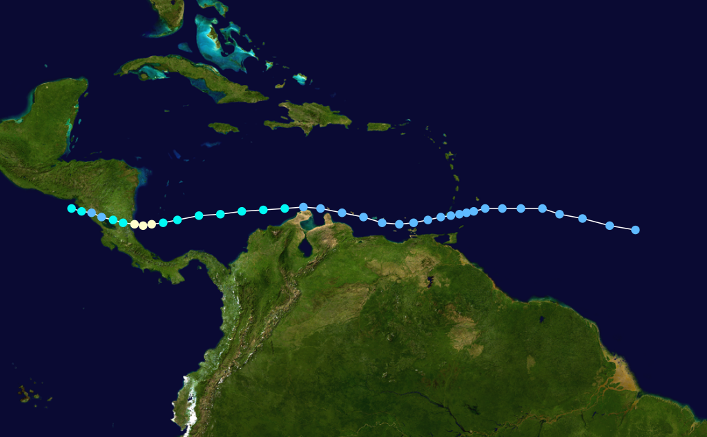
Formed=September 11
Dissipated=September 20
1-min winds=70
Pressure=989Hurricane Irene formed from a tropical wave onSeptember 11 , located about 700 miles east of the Lesser Antilles. Its rapid movement and its southerly track over the Caribbean kept it as a tropical depression until the 17th, when it slowed over the southwest Caribbean. Irene intensified at a steady rate to an 80 mph hurricane prior to itsSeptember 19 landfall onNicaragua . After crossing Central America, Irene restrengthened to a 115 mph hurricane in the Eastern Pacific as Hurricane Olivia.Tropical Storm Janice
Infobox Hurricane Small
Basin=Atl
Formed=September 21
Dissipated=September 24
1-min winds=55
Pressure=1005The tropical depression that became Tropical Storm Janice developed from a tropical wave that originated off the coast of Africa. Forming onSeptember 21 east of the Lesser Antilles, the depression reached tropical storm strength, but upper level shear disallowed the storm to strengthen beyond 65 mph winds. Janice dissipated on the 24th.Tropical Storm Kristy
Infobox Hurricane Small
Basin=Atl
Formed=October 18
Dissipated=October 21
1-min winds=45
Pressure=992The precursor of Tropical Storm Kristy was a tropical wave combined with an upper level trough. A tropical depression formed from this area of convection onOctober 18 , and on the 20th while moving northeastward, it became Tropical Storm Kristy. As it reached this strength, it was already encountering unfavorable conditions, and Kristy became extratropical on the 21st.Tropical Storm Laura
Infobox Hurricane Small
Basin=Atl
Formed=November 12
Dissipated=November 22
1-min winds=60
Pressure=994A large, sprawling cloud mass originating overPanama formed a tropical depression onNovember 12 in the Caribbean Sea. Two days after its formation, it became a tropical storm northeast of the coast ofHonduras . Laura moved to the northwest for the following days due to an approaching cold front, but when a high pressure built to its north on the 16th, Laura executed a small loop just south ofCuba , resulting in rainfall amounts up to 825 mm/32.48 inches.cite web|author=Instituto Nacional de Recursos Hidráulicos|year=2003|title=Lluvias intensas observadas y grandes inundaciones reportadas|language=Spanish|accessdate=2007-02-10|url=http://www.hidro.cu/hidrologia1.htm] Here Laura reached her peak intensity of 70 mph. As Laura moved to the southwest, she weakened drastically, but managed to regain her peak intensity prior to her landfall onBelize (then known asBritish Honduras ) on the 21st. Laura dissipated the next day overCentral America .With an ACE of 8.61, Laura had the highest ACE of any Atlantic storm that didn't reach hurricane strength.
torm names
The following names were used for named storms (tropical storms and hurricanes) that formed in the North Atlantic in 1971. [cite news|author=Don Kirkman|date=1971-05-31|title=Weather Service Hurricane Namers Defy Women's Lib|publisher=Scripps-Howard Staff Writer|accessdate=2007-12-01|format=PDF|url=http://www.thehurricanearchive.com/Viewer.aspx?
] Names that were not assigned are marked in tcname unused. No names were retired after the 1971 season.
ee also
*
List of Atlantic hurricanes
*List of Atlantic hurricane seasons
*List of wettest tropical cyclones in Cuba since 1963
*1971 Pacific hurricane season
*1971 Pacific typhoon season
*1971 North Indian Ocean cyclone season
*Southern Hemisphere tropical cyclone seasons: 1970–71, 1971–72References
External links
* [http://www.aoml.noaa.gov/general/lib/lib1/nhclib/mwreviews/1971.pdf Monthly Weather Review]
* [http://www.hpc.ncep.noaa.gov/tropical/rain/fern1971.html Hurricane Fern Rainfall Information]

Wikimedia Foundation. 2010.