- 1979 Atlantic hurricane season
Infobox hurricane season
Basin=Atl
Year=1979
Track=1979 Atlantic hurricane season map.pngJune 19 ,1979
Last storm dissipated=October 25 ,1979
Strongest storm name=David
Strongest storm winds=150
Strongest storm pressure=924
Average wind speed=1
Total depressions=
Total storms=9
Total hurricanes=5
Total intense=2
Fatalities=2118
Da
Inflated=1
five seasons=1977, 1978, 1979, 1980, 1981June 1 ,1979 , and lasted untilNovember 30 ,1979 . These dates conventionally delimit the period of each year when mosttropical cyclone s form in theAtlantic basin .The most notable storm of 1979 was
Hurricane David , a Category 5 storm on theSaffir-Simpson Hurricane Scale that killed over 2,000 people, mostly in theDominican Republic , and caused nearly 1.5 billion dollars in damage (1979 USD).Hurricane Frederic , which caused $2.3 billion (1979US dollars ; $6.5 billion in 2005 USD), became the most expensive hurricane inUnited States history (at the time) when it made landfall near the border betweenMississippi andAlabama .eason summary
The 1979 season was an average but destructive season with 27 depressions, but only 9 became storms. The notable cyclones include Tropical Depression Two which caused one of Jamaica's worst natural disasters. Tropical Storm Claudette became one of the most destructive tropical storms of all time and creating a 24-hour rainfall record at the time.
Hurricane David peaked at Category 5 status becoming the first hurricane of such strength to make landfall directly in theDominican Republic , killing over 2000 people. Hurricane Frederic became a weak Category 4 hurricane with winds of convert|135|mi/h|km/h|abbr=on, doing over $4-8 billion dollars in damage (2005 USD) to the same area as Hurricane David. Hurricane Henri formed in Mid-September in theGulf of Mexico and never made landfall, which is a rare occurrence. Damage for the whole season totaled out to $12.1 billion (2005 USD). [http://ams.allenpress.com/archive/1520-0493/108/7/pdf/i1520-0493-108-7-966.pdf Tropical depressions of the 1979 season] ]torms
Tropical Depression One
Infobox Hurricane Small
Basin=Atl
1-min winds=30Tropical Depression Two
Infobox Hurricane Small
Basin=Atl
Formed=June 11
Dissipated=June 16
1-min winds=30A tropical depression formed west ofJamaica onJune 11 produced heavy rainfalls with record floods in several parishes for two days withmaximum sustained wind s of convert|35|mph|km/h. The depression continued north, parallelling theFlorida coast onJune 15 and made landfall inSouth Carolina onJune 16 . Tropical Depression Two dissipated over land. The town of Friendship recorded convert|32|in|mm of rain with 15 in other parts of western Jamaica. Due to saturated mud from other rains, caused one ofJamaica 's worst natural disaster in the 70s. Over 210,000 people were affected by floods onJune 12 alone causing for major damage. [http://www.em-dat.net/disasters/Visualisation/profiles/natural-table-emdat.php?country=Jamaica EM-DAT's Jamaica Page] ] Economic damages totalled out to $27 million (1979 USD-$75 million in 2006 USD) with forty people killed. [http://www.aoml.noaa.gov/general/lib/lib1/nhclib/mwreviews/1979.pdf 1979 Monthly Weather Review] ] [http://www.odpem.org.jm/articles/articles/2_23_2005190.asp MANAGING NATURAL HAZARDS IN JAMAICA] ]The flooding in western Jamaica from Tropical Depression Two devastated the area and caused the government to establish a permanent disaster management organization. [http://www.odpem.org.jm/about_us/index.html Office of Disaster Preparedness and Emergency Management] ]
Tropical Storm Ana
Infobox Hurricane Small
Basin=Atl
Track=Ana 1979 track.pngJune 19
Dissipated=June 24
1-min winds=50
Pressure=1005tropical depression east of theLesser Antilles onJune 19 . She was one of the first tropical storms to develop that far east during the month of June since the1933 Atlantic hurricane season . The depression curved gently northwest and strengthened into Tropical Storm Ana while convert|100|mi|km northeast of Barbados onJune 22 . Ana crossed theLeeward Islands and weakened into a tropical depression. The storm degenerated the next morning in the centralCaribbean Sea . [http://www.nhc.noaa.gov/archive/storm_wallets/atlantic/atl1979-prelim/ana/ Tropical Storm Ana Preliminary Report] ]Tropical Depression Four
Infobox Hurricane Small
Basin=Atl
1-min winds=30Hurricane Bob
Infobox Hurricane Small
Basin=Atl.jpg)
Track=Bob 1979 track.pngJuly 9
Dissipated=July 13
1-min winds=65
Pressure=986Gulf of Mexico and curved northeast. The storm strengthened rapidly, reaching hurricane strength a couple hundred miles south of theLouisiana coast onJuly 11 . It made landfall nearDulac, Louisiana later that day, killing two people and causing $20 million ($55.56 million in 2006USD ) in damages. Bob dropped 3-5 inches of rain over southern Indiana before looping over themid-Atlantic states and out into theAtlantic Ocean . [http://www.nhc.noaa.gov/archive/storm_wallets/atlantic/atl1979-prelim/bob/ Hurricane Bob Preliminary Report] ] The storm finally dissipated onJuly 16 .Bob was the first July hurricane in the
Gulf of Mexico since Hurricane Debra in the 1959 season as well as the firstAtlantic hurricane to have a male name from the new alternating male-female lists. [http://www.ohsep.louisiana.gov/factsheets/WhyHurricanesAreNamed.htm Why Hurricanes Are Named] ] .Tropical Storm Claudette
Infobox Hurricane Small
Basin=Atl
Track=Claudette 1979 track.pngJuly 16
Dissipated=July 26
1-min winds=45
Pressure=997July 15 -July 29 ) but fairly weak storm that spent almost its entire life as a tropical depression. Claudette formed in the centralAtlantic east of theWindward Islands . It had two spells as a tropical storm; the first was a brief one east ofPuerto Rico . The storm passed directly over the island just after weakening, where it killed one person from flooding. The depression moved casually through theGreater Antilles and moved into the Gulf of Mexico. Claudette restrengthened into a tropical storm south ofSabine, Texas and made landfall near Port Arthur, killing one person from floods. The storm stalled overAlvin, Texas on the evening of the 25th, and dropped convert|45|in|mm of rain there over the next 42 hours; this included convert|43|in|mm in 24 hours, the record 24-hour rainfall in US history at the time. Damages from flooding in Texas were enormous, totaling $400 million (1979 USD ($1.1 billion 2005 USD)). [http://www.nhc.noaa.gov/archive/storm_wallets/atlantic/atl1979-prelim/claudett/ Tropical Storm Claudette Preliminary Report] ] Claudette was one of the costliest storms on record that never reached hurricane intensity.Tropical Depression Nine
Infobox Hurricane Small
Basin=Atl
1-min winds=30Tropical Depression Ten
Infobox Hurricane Small
Basin=Atl
Formed=July 28
Dissipated=August 6
1-min winds=30The tenth tropical depression of the 1979 season formed onJuly 28 south of where TD Nine formed a week before. The depression moved to the northwest, making landfall as a tropical depression inBermuda onAugust 4 . The depression made landfall on the southeastern tip of Newfoundland onAugust 5 after passing southeast ofNova Scotia earlier that morning. Tropical Depression Ten dissipated onAugust 6 southeast ofLabrador . No damage or fatality reports are available.Hurricane David
Infobox Hurricane Small
Basin=Atl
Track=David 1979 track.pngAugust 25
Dissipated=September 6
1-min winds=150
Pressure=924Atlantic hurricane s on record. It formed from atropical wave in the central Atlantic east of theWindward Islands . The storm headed west, steadily strengthening. By the time David reached theLeeward Islands , it was at Category 4 intensity. David continued strengthening and reached Category 5 status south ofPuerto Rico . It spent nearly two days at Category 5 intensity, storming throughSanto Domingo , the capital of theDominican Republic . CrossingHispaniola weakened the storm greatly however, and David exited the island as a weak Category 1. It strengthened into aCategory 2 off the southFlorida coast. The western eyewall crossed the shoreline near Fort Lauderdale and continued up the entire length of the coast. The beach erosion was severe. David made landfall nearSavannah, Georgia as a Category 1 and dissipated inland. David killed over 2,000 people in Hispaniola, 56 people on the island ofDominica , and 12 people in the U.S. as well as causing $1.54 billion (1979 USD ($4.36 billion 2005 USD)) in damage.David was only one of two storms to "directly" impact the Dominican Republic at such intensity, the only other being the Hurricane 2 of 1930. [http://www.nhc.noaa.gov/archive/storm_wallets/atlantic/atl1979-prelim/david/ Hurricane David Preliminary Report] ]
Hurricane Frederic
Infobox Hurricane Small
Basin=Atl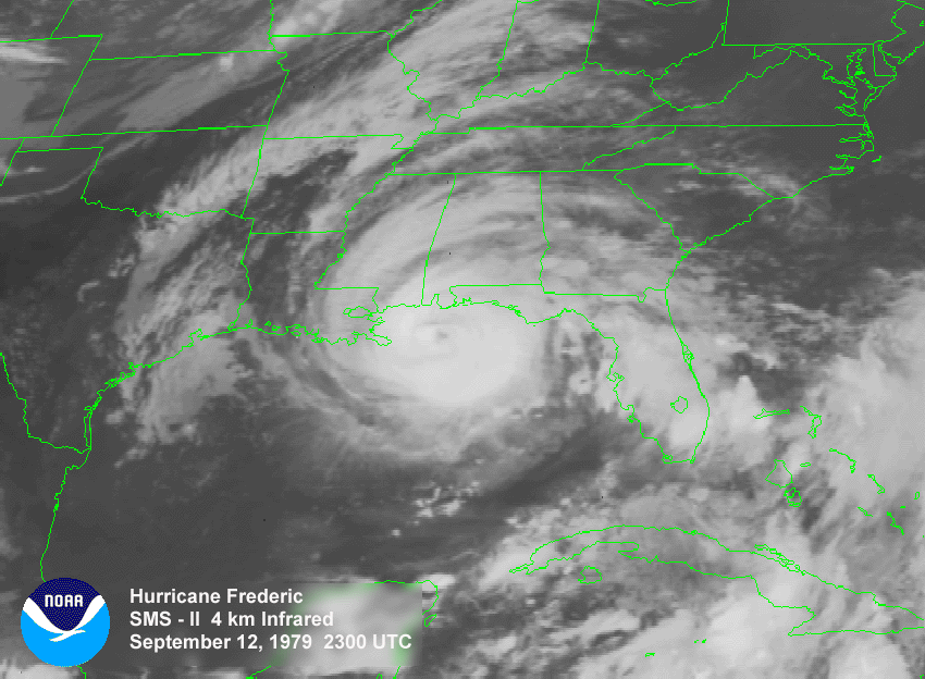
Track=Frederic 1979 track.pngAugust 29
Dissipated=September 14
1-min winds=117
Pressure=943Cape Verde-type hurricane . It first became a hurricane in the central Atlantic east of theWindward Islands but soon weakened back into a tropical storm. Frederic crossed Hispaniola and weakened into a tropical depression. Frederic then crossedCuba and regained tropical storm strength before entering theGulf of Mexico . It was then that Frederic started to strengthen rapidly. By the time it reached a point just east of theMississippi River Delta , Frederic was a Category 4. It made landfall near theAlabama /Mississippi border. Due to prior warning, the death toll was a minimal five people; however, damages soared to $2.3 billion (1979 dollars ($6.5 billion 2005 dollars)) in damage.Tropical Storm Elena
Infobox Hurricane Small
Basin=Atl
Track=Elena 1979 track.pngAugust 30
Dissipated=September 2
1-min winds=35
Pressure=1004Florida onAugust 27 , however onAugust 29 , ship and buoy reports mentioned a low-level circulation forming. An Air Forcereconnaissance flight confirmed the report and was upgraded into Tropical Depression Six on the same day. Slow development occurred causing the depression to gain strength slowly, however by the next day, it was able to strengthen into Tropical Storm Elena. Elena did not intensify, peaking at 40mph with a pressure of 1004 mbar. Elena turned toward the Texas coast nearMatagorda Bay , spawning watches and warnings and made landfall onSeptember 1 as a weak tropical storm. Elena could not even be identified as a tropical depression by the next day. [http://www.nhc.noaa.gov/archive/storm_wallets/atlantic/atl1979-prelim/elena/ Tropical Storm Elena Preliminary Report] ]Elena caused less than $10 million dollars (1979 USD) ($28 million 2005 USD) in damage but managed to kill two people in floods.
Hurricane Gloria
Infobox Hurricane Small
Basin=Atl
Track=Gloria 1979 track.pngSeptember 4
Dissipated=September 15
1-min winds=85
Pressure=975September 4 off the northwestern African coast. As common with early September, TD Seventeen took a northwesterly direction, passing to the northeast of theCape Verde Islands . The northwesterly course was influenced by the depression's large size. OnSeptember 6 , the depression became Tropical Storm Gloria and reached hurricane strength the next day. After becoming a hurricane, Gloria slowed down to just about convert|15|mi/h|km/h|abbr=on to the northwest untilSeptember 10 . However, rising pressures caused Gloria to go in a westerly drift for a few days. Rapid acceleration to the northeast occurred with satellites indicating that Gloria had reached her peak intensity of convert|105|mi/h|km/h|abbr=on onSeptember 13 with a minimum pressure of 975 mbar. Gloria merged with a low-pressure system onSeptember 15 and lost tropical characteristics.Gloria did not affect landmasses and was only a threat to marine interests. [http://www.nhc.noaa.gov/archive/storm_wallets/atlantic/atl1979-prelim/gloria/ Hurricane Gloria Preliminary Report] ]
Hurricane Henri
Infobox Hurricane Small
Basin=Atl
Track=Henri 1979 track.pngSeptember 15
Dissipated=September 22
1-min winds=75
Pressure=983Gulf of Mexico . It formed as a tropical depression offCancún and curved around the peninsula, entering theBay of Campeche . Henri quickly strengthened into a tropical storm and reached hurricane strength onSeptember 17 . It soon weakened back to a tropical storm and stalled offTampico, Mexico . Henri then doubled back the way it came, weakened into a tropical depression, and curved sharply east into the open Gulf of Mexico, dissipating in the eastern Gulf. No damage was reported. This was a rare example of a storm entering the Gulf of Mexico and dissipating without making landfall. [http://www.nhc.noaa.gov/archive/storm_wallets/atlantic/atl1979-prelim/henri/ Hurricane Henri Preliminary Report] ]Tropical Depression Nineteen
Infobox Hurricane Small
Basin=Atl
1-min winds=30Tropical Depression Twenty
Infobox Hurricane Small
Basin=Atl
Formed=September 19
Dissipated=September 21
1-min winds=30The 20th tropical depression of the 1979 season formed as a non-tropical low onSeptember 19 off the coast ofBrownsville, Texas . The low appeared in the same area as Hurricane Henri was drifting around in theGulf of Mexico . The low became TD 20 on the 20th of September off the Texas coast. The depression made landfall in Texas onSeptember 21 , dissipating over land. The depression left 10-15 inches of rainfall throughout the area from Corpus Christi, Texas to southwestern Louisiana.Tropical Depression Twenty-One
Infobox Hurricane Small
Basin=Atl
1-min winds=30Tropical Depression Twenty-Two
Infobox Hurricane Small
Basin=Atl
Formed=October 12
Dissipated=October 20
1-min winds=30A tropical depression formed onOctober 12 nearHonduras and moved to the northeast towardsCuba . The depression passed by Cuba and turned back towards theYucatan Peninsula . The depression made landfall in the Yucatan onOctober 20 and dissipated afterwards.ubtropical Storm One
Infobox Hurricane Small
Basin=Atl
Type=subtropical
Track=1979 Atlantic subtropical storm 1 track.pngOctober 23
Dissipated=October 25
1-min winds=65
Pressure=980Bermuda onOctober 23 and headed north. The subtropical depression grazed Bermuda and became a subtropical storm. This unnamed storm continuednorth and continued to strengthen. The storm briefly reached hurricane strength (though it was not a "hurricane " because it was not tropical) before weakening. The storm made landfall on Newfoundland on the 25th and dissipated later that day. No damage was reported. [http://www.nhc.noaa.gov/archive/storm_wallets/atlantic/atl1979-prelim/subtrop/ Subtropical Storm One Preliminary Report] ]Tropical Depression Twenty-Five
Infobox Hurricane Small
Basin=Atl
Formed=October 24
Dissipated=October 29
1-min winds=30The 25th tropical depression of the 1979 season formed nearPanama onOctober 24 . The depression moved to the north towardsCuba but changed directions and headed towardsNicaragua , where it made landfall onOctober 29 , dissipating over land.Tropical Depression Twenty-Six
Infobox Hurricane Small
Basin=Atl
Formed=November 8
Dissipated=November 8
1-min winds=30The 26th tropical depression of the 1979 season formed from an old baroclinic zone onNovember 8 nearPuerto Rico . The depression moved northeastward but appeared to have made contact with the westerlies. However, strong pressure rises caused the depression to weaken and turn back to the southwest. Ships that passed through the system recorded winds of 35-40 mph. [http://ams.allenpress.com/archive/1520-0493/108/7/pdf/i1520-0493-108-7-966.pdf Tropical depressions of the 1979 season] ]Accumulated Cyclone Energy (ACE) Rating
The table on the right shows the ACE for each storm in the season. The ACE is, broadly speaking, a measure of the power of the hurricane multiplied by the length of time it existed for, so hurricanes that lasted a long time have higher ACEs.
torm names
The following names were used for named storms that formed in the north Atlantic in 1979. This season marked the debut of the current set of six lists containing both male and female names, replacing the ten-year set of female name lists introduced in 1971; this was due to protests from women's rights groups. Unisex names were considered, though prior to the start of the season the
World Meteorological Organization approved of the current list alternating between male and female names of English, Spanish, and French origin.cite web|author=National Geographic News Service|date=1979-07-24|title=His and hur-ricane season comes East for first time|accessdate=2007-12-01|url=http://www.thehurricanearchive.com/Viewer.aspx?] Initially, male names were scheduled to be introduced in the 1981 season.cite web|author=Associated Press|date=1978-05-31|title=Hedge Bets on Hurricanes|accessdate=2007-12-01|url=http://www.thehurricanearchive.com/Viewer.aspx?
] The name Elena was previously used in the 1965 season, and the name Gloria was used in 1976. The names not retired from this list were used again in the 1985 season. Names that were not assigned are marked in tcname unused.
Retirement
The
World Meteorological Organization retired two names in the spring of 1980: David and Frederic. They were replaced in the 1985 season by Danny and Fabian.ee also
*
List of Atlantic hurricanes
*List of Atlantic hurricane seasons
*1979 Pacific hurricane season
*1979 Pacific typhoon season
*1979 North Indian Ocean cyclone season
*Southern Hemisphere tropical cyclone seasons: 1978–79, 1979–80References
External links
* [http://www.aoml.noaa.gov/general/lib/lib1/nhclib/mwreviews/1979.pdf Monthly Weather Review]
* [http://www.hpc.ncep.noaa.gov/tropical/rain/1979.html HPC rainfall pages for 1979 tropical cyclones impacting North America]

Wikimedia Foundation. 2010.