- Dyce
-
"Bridgefield" redirects here. For the redevelopment project in Stockport, England, see Merseyway.For other uses, see Dyce (disambiguation).
Coordinates: 57°12′11″N 2°11′31″W / 57.2031°N 2.1920°W
Dyce Scots: Dyce 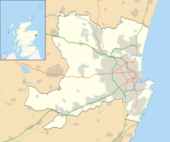
 Dyce
Dyce
Dyce shown within the City of AberdeenPopulation 5,811 [1] Language English Scots (Doric) OS grid reference NJ885125 - Edinburgh 99 mi (159 km) [2] - London 408 mi (657 km) [2] Parish Dyce Council area Aberdeen Lieutenancy area Aberdeen Country Scotland Sovereign state United Kingdom Post town Aberdeen Postcode district AB21 Dialling code 01224 Police Grampian Fire Grampian Ambulance Scottish EU Parliament Scotland UK Parliament Gordon Scottish Parliament North East Scotland Aberdeen Donside Website aberdeencity.gov.uk List of places: UK • Scotland • Aberdeen Dyce (Scottish Gaelic: Deis) is a civil parish and suburb of Aberdeen, Scotland, about 6 miles (9.7 km) north west of Aberdeen city centre, and best known as the location of the city's airport. It is on the River Don.
History
Dyce is the site of an early medieval church dedicated to the 8th century missionary and bishop St. Fergus, otherwise associated with Glamis, Angus. Today the cemetery, north of the airport, and overlooking the River Don, hosts the roofless but otherwise virtually complete former St. Fergus Chapel, within which Pictish and early Christian stones from the 7th–9th centuries, found in or around the churchyard, are displayed (Historic Scotland; open at all times without entrance charge).
The Chapel is a unicameral late medieval building with alterations perhaps of the 17th or 18th centuries. Two further carved stones, of uncertain (though probably early) character, were discovered re-used as building rubble in the inner east gable and outer south wall during the chapel's restoration. They were left in situ and are readily visible. A broken font, somewhat resembling a round-backed chair in its present condition, lies outside the church, and may also be of early medieval date.
The graveyard surrounding the old church was used into the 20th century, and retains almost no old gravestones. There is a small 'mort house' in one corner of the enclosure, which is adjoined by a modern extension, still in use for burials.
Facilities
Dyce has one main shopping centre which is mainly an Asda store with a Boots chemist, a hairdresser, a pet shop, and a travel agent. The local secondary school, Dyce Academy has about 500 pupils. There is also a primary school, Dyce Primary School.
Dyce railway station is served by First ScotRail and East Coast trains on the Aberdeen to Inverness Line.
The area of Aberdeen has good sports facilities including the local junior football team Dyce F.C who currently play in the Scottish Junior Football Association North Region and the cricket team. Dyce also have an amateur football team, currently named Dyce ITC Hydraulics in honour of its sponsors ITC Hydarulics also of Dyce. Dyce ITC currently play in the Aberdeenshire Amateur Association Premier League and play their home games at Pitmedden Road in Dyce.
Aberdeen wins 'Britain In Bloom' nearly all the time with [(Dyce)], North-West end of Aberdeen, winning awards in its own right.
Halliburton has an office in Dyce.[3]
References
- ^ [1] 2009:Population of Aberdeen's Neighbourhoods
- ^ a b Indo.com. "How Far Is It?". http://www.indo.com/distance/index.html. Retrieved 2007-03-13.
- ^ "Office Location." Halliburton. Retrieved on 13 January 2009.
Areas of Aberdeen 
- See Areas of Aberdeen for a more complete list of the city's districts and areas.
Altens · Balnagask · Bieldside · Bridge of Dee · Bridge of Don · Broomhill · Bucksburn · Cornhill · Cove Bay · Cults · Danestone · Dyce · Footdee · Foresterhill · Garthdee · Hazlehead · Hilton · Kincorth · Kingswells · Kittybrewster · Mannofield · Mastrick · Midstocket · Milltimber · Nigg · Northfield · Old Aberdeen · Peterculter · Queen's Cross · Rosemount · Rubislaw · Summerhill · Tillydrone · Torry · Tullos · Woodside
Categories:


Wikimedia Foundation. 2010.