- Kew Gardens (LIRR station)
-
Kew Gardens 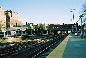
Kew Gardens Station and the Lefferts Boulevard BridgeStation statistics Address Austin Street & Lefferts Boulevard
Kew Gardens, New YorkCoordinates 40°42′35″N 73°49′50″W / 40.7096°N 73.83066°WCoordinates: 40°42′35″N 73°49′50″W / 40.7096°N 73.83066°W Lines Connections  MTA Bus: Q10, Q37
Platforms 2 side platforms Tracks 4 Parking Yes Other information Opened 1879, 1883 Closed 1882, 1909 Rebuilt September 8, 1910 Electrified June 23, 1910
750V (DC) third railAccessible 
Owned by MTA Fare zone 1 Formerly Maple Grove(1879-1910)
Kew(1910-1912)Traffic Passengers (2006) 1,631[1] Services Preceding station LIRR Following station toward Penn StationCity Terminal Zone toward Long IslandKew Gardens is a railroad station on the Main Line of the Long Island Rail Road in Kew Gardens, Queens. The station is located at Austin Street and Lefferts Boulevard. One of Kew Garden station's unique features is the 119th Street(Lefferts Boulevard) Bridge which has one story commercial buildings on both sides for local businesses.
The Main Line has four tracks; the two middle tracks not next to either platform, are used by express trains.
Contents
History
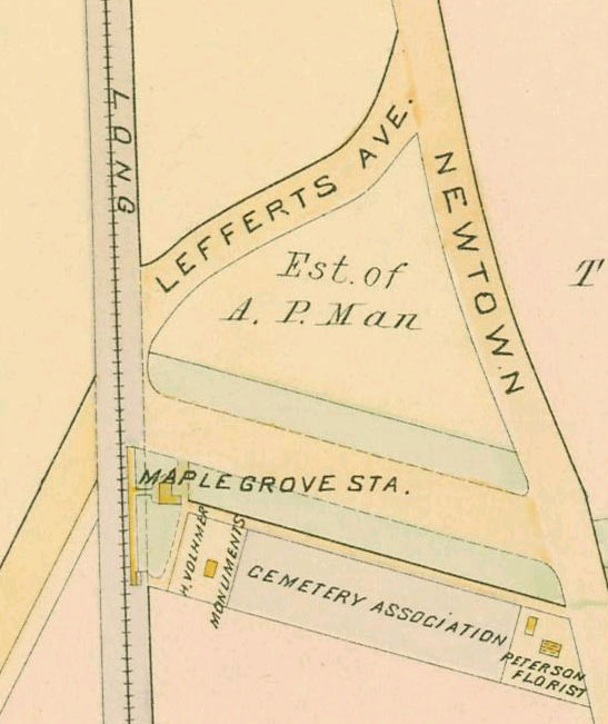
 The former Maple Grove Station, 18 years before the LIRR realignment project.
Kew Gardens Station originally opened in May 1879 as Maple Grove, a flag stop for Maple Grove Cemetery. The station was closed in 1882, reopened in 1883, and removed in 1909 as part of a track realignment project. The new Kew Station was moved approximately 600 feet south alongside and perpendicular to the tracks for use as a real estate office of developers of Kew on September 8, 1910. The former station was razed a short time later, and the existing station was renamed Kew Gardens in 1912.
The Kew Gardens station has the unfortunate distinction of being the site of the worst accident in Long Island Rail Road history, as well as the worst in New York state history. On November 22, 1950, a collision between two Long Island Rail Road commuter trains killed 79 people and injured hundreds.[2][3] This occurred nine months after a collision at Rockville Centre Station on February 17, 1950 that resulted in the deaths of 32 people, and serious injury of 158 people.[4] A far more notorious historical aspect is the 1964 murder of Kitty Genovese, which occurred near this station.
Platforms and tracks
This station has two high-level side platforms each four cars long; generally, the first four cars of a train in either direction will receive and discharge passengers at this station. The north platform next to Track 3 is generally used by westbound or Manhattan-bound trains. The south platform next to Track 4 is generally used by eastbound or outbound trains. Most LIRR trains that pass through the station do not stop.
References
- ^ Average weekday, 2006 LIRR Origin and Destination Study
- ^ "The 1950 LIRR crash at Kew Gardens/Richmond Hill". http://www.oldkewgardens.com/ss-lirr-0650.html.
- ^ About the Long Island Rail Road's Worst Train Crash (Richmond Hill Historical Society)
- ^ Long Island Rail Road Wrecks
External links
- Official LIRR station information page for Kew Gardens
- Station timetable for Kew Gardens
- Kew Gardens Station (The SubwayNut)
- A Picture History of Kew Gardens, New York
- Kew Gardens Station (www.oldkewgardens.com)
- Kew Gardens Station; July 18, 2001 (RailPictures.net)
- Station House from Google Maps Street View
Categories:- Long Island Rail Road stations
- Buildings and structures in Queens
- Railway stations opened in 1910
- Transportation in Queens

Wikimedia Foundation. 2010.