- Maykopsky District
-
Maykopsky District (English)
Майкопский район (Russian)
Мыекъуапэ район (Adyghe)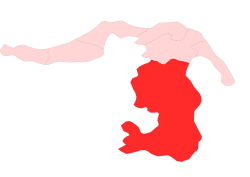
Location of Maykopsky District in the Republic of AdygeaHoliday Observed in September[citation needed] Administrative status (as of 2007) Country Russia Federal subject Republic of Adygea Administrative center urban-type settlement of Tulsky[citation needed] # of cities/towns —[citation needed] # of urban-type settlements 2[citation needed] # of rural localities 54[citation needed] - Leader Yevgeny Kovalyov[citation needed] - Representative body Council of People's Deputies[citation needed] - # of urban settlements 2[citation needed] - # of rural settlements 8[citation needed] Statistics Area 3,667.43 km2 (1,416.00 sq mi)[citation needed] Population (2010 Census,
preliminary)58,459 inhabitants[1] Population (2002 Census) 58,485 inhabitants[2] - Urban population 0% - Rural population 100% Density 16 /km2 (41 /sq mi)[3] Time zone MSD (UTC+04:00)[4] Established April 28, 1962[citation needed] District newspaper Mayak (Lighthouse)[citation needed] Maykopsky District (Russian: Майко́пский райо́н; Adyghe: Мыекъуапэ район) is an administrative and a municipal district, one of the seven in the Republic of Adygea, Russia. It comprises the southern portion of the republic and borders with Giaginsky District in the north, Mostovsky District of Krasnodar Krai in the east, territory of the city of Sochi of Krasnodar Krai in the south, Apsheronsky District of Krasnodar Krai in the west and southwest, and Belorechensky District of Krasnodar Krai in the northwest. The area of the district is 3,667.43 square kilometers (1,416.00 sq mi).[5] Its administrative center is the urban locality (an urban-type settlement) of Tulsky. District's population: 58,459 (2010 Census preliminary results);[1] 58,485 (2002 Census);[2] 58,593 (1989 Census).[6] Population of Tulsky accounts for 18.4% of the district's population.[1]
The district was first established on December 28, 1934 as an administrative division of Azov-Black Sea Krai. It was renamed Tulsky on April 10, 1936. When Azov-Black Sea Krai was divided into Krasnodar Krai and Rostov Oblast in September 1937, Tulsky District remained a part of the former. On February 21, 1940, Maykopsky District was established within Adyghe Autonomous Oblast, and on April 28, 1962 Tulsky District of Krasnodar Krai was merged into it.[5]
Contents
Divisions
Administrative divisions
Maykopsky District has administrative jurisdiction over one urban-type settlement and fifty-five rural localities.
Municipal divisions
Municipally, the district is divided into one urban settlement and nine rural settlements:[7]
- Urban settlements
- Tulskoye (Тульское)
- urban-type settlement of Tulsky
- rural localities under jurisdiction of the urban-type settlement:
- selo of Makhoshepolyana
- Rural settlements
- Abadzekhskoye (Абадзехское)
- Administrative center: stanitsa of Abadzekhskaya
- other localities of the rural settlement:
- stanitsa of Novosvobodnaya
- settlement of Pervomaysky
- stanitsa of Sevastopolskaya
- khutor of Vesyoly, Abadzekhskoye Rural Settlement
- Dakhovskoye (Даховское)
- Administrative center: stanitsa of Dakhovskaya
- other localities of the rural settlement:
- selo of Khamyshki
- settlement of Merkulayevka
- selo of Novoprokhladnoye
- settlement of Ust-Sakhray
- Kamennomostskoye (Каменномостское)
- Administrative center: settlement of Kamennomostsky
- other localities of the rural settlement:
- settlement of Pobeda (Kamennomostsky)
- khutor of Vesyoly (Kamennomostsky)
- Kirovskoye (Кировское)
- Administrative center: khutor of Severo-Vostochnye Sady
- other localities of the rural settlement:
- khutor of 17 Let Oktyabrya
- khutor of Dyakov
- khutor of Grozny, Kirovskoye Rural Settlement
- aul of Mafekhabl
- khutor of Oktyabrsky
- khutor of Proletarsky
- khutor of Sovetsky
- Krasnooktyabrskoye (Краснооктябрьское)
- Administrative center: settlement of Krasnooktyabrsky
- other localities of the rural settlement:
- stanitsa of Dagestanskaya
- khutor of Krasny Most
- stanitsa of Kurdzhipskaya
- settlement of Mirny
- settlement of Prirechny
- khutor of Sadovy, Krasnooktyabrskoye Rural Settlement
- settlement of Spokoyny
- settlement of Tabachny
- Krasnoulskoye (Красноульское)
- Administrative center: khutor of Krasnaya Ulka
- other localities of the rural settlement:
- khutor of Grazhdansky
- khutor of Kalinin
- khutor of Komintern
- khutor of Tkachyov
- khutor of Volny
- Kuzhorskoye (Кужорское)
- Administrative center: stanitsa of Kuzhorskaya
- other localities of the rural settlement:
- khutor of Karmir-Astakh
- settlement of Tryokhrechny
- Pobedenskoye (Победенское)
- Administrative center: settlement of Sovkhozny
- other localities of the rural settlement:
- khutor of Grozny, Pobedenskoye Rural Settlement
- settlement of Pobeda, Pobedenskoye Rural Settlement
- khutor of Prichtovsky
- khutor of Shaumyan
- settlement of Udobny
- Timiryazevskoye (Тимирязевское)
- Administrative center: settlement of Timiryazeva
- other localities of the rural settlement:
- settlement of Michurina
- settlement of Podgorny
- settlement of Sadovy, Timiryazevskoye Rural Settlement
- khutor of Shuntuk
- settlement of Tsvetochny
- Rural localities under the district's jurisdiction
- stanitsa of Bezvodnaya
- settlement of Guzeripl
- settlement of Khakodz
See also
- List of administrative and municipal divisions of the Republic of Adygea
References
- ^ a b c Федеральная служба государственной статистики (Federal State Statistics Service) (2011). "Предварительные итоги Всероссийской переписи населения 2010 года (Preliminary results of the 2010 All-Russian Population Census)" (in Russian). Всероссийская перепись населения 2010 года (All-Russia Population Census of 2010). Federal State Statistics Service. http://www.perepis-2010.ru/results_of_the_census/results-inform.php. Retrieved 2011-04-25.
- ^ a b Федеральная служба государственной статистики (Federal State Statistics Service) (2004-05-21). "Численность населения России, субъектов Российской Федерации в составе федеральных округов, районов, городских поселений, сельских населённых пунктов – районных центров и сельских населённых пунктов с населением 3 тысячи и более человек (Population of Russia, its federal districts, federal subjects, districts, urban localities, rural localities—administrative centers, and rural localities with population of over 3,000)" (in Russian). Всероссийская перепись населения 2002 года (All-Russia Population Census of 2002). Federal State Statistics Service. http://www.perepis2002.ru/ct/doc/1_TOM_01_04.xls. Retrieved 2010-03-23.
- ^ The value of density was calculated automatically by dividing the 2010 Census population by the area specified in the infobox. Please note that this value may not be accurate as the area specified in the infobox does not necessarily correspond to the area of the entity proper or is reported for the same year as the population.
- ^ Правительство Российской Федерации. Постановление №725 от 31 августа 2011 г. «О составе территорий, образующих каждую часовую зону, и порядке исчисления времени в часовых зонах, а также о признании утратившими силу отдельных Постановлений Правительства Российской Федерации». Вступил в силу по истечении 7 дней после дня официального опубликования. Опубликован: "Российская Газета", №197, 6 сентября 2011 г. (Government of the Russian Federation. Resolution #725 of August 31, 2011 On the Composition of the Territories Included into Each Time Zone and on the Procedures of Timekeeping in the Time Zones, as Well as on Abrogation of Several Resolutions of the Government of the Russian Federation. Effective as of after 7 days following the day of the official publication).
- ^ a b Charter of the Municipal Formation of "Maykopsky District" adopted on February 20, 2003, as amended by the Resolution of the Council of People's Deputies of Maykopsky District On Introduction of Amendments and Supplements into the Charter of the Municipal Formation of "Maykopsky District" of May 19, 2005
- ^ "Всесоюзная перепись населения 1989 г. Численность наличного населения союзных и автономных республик, автономных областей и округов, краёв, областей, районов, городских поселений и сёл-райцентров. (All Union Population Census of 1989. Present population of union and autonomous republics, autonomous oblasts and okrugs, krais, oblasts, districts, urban settlements, and villages serving as district administrative centers.)" (in Russian). Всесоюзная перепись населения 1989 года (All-Union Population Census of 1989). Demoscope Weekly (website of the Institute of Demographics of the State University—Higher School of Economics. 1989. http://demoscope.ru/weekly/ssp/rus89_reg.php. Retrieved 2010-03-23.
- ^ Совет Республики Адыгея. Закон №283 от 30 декабря 2004 г. «О наделении муниципального образования "Майкопский район" статусом муниципального района, об образовании и наделении статусом поселений муниципальных образований в его составе и установлении их границ», в ред. Закона №25 от 8 августа 2011 г «О внесении изменений в некоторые Законы Республики Адыгея». Вступил в силу со дня официального опубликования. Опубликован: "Советская Адыгея", №2–5, 12 января 2005 г. (Council of the Republic of Adygea. Law #283 of December 30, 2004 On Granting the Municipal Formation of "Maykopsky District" the Status of a Municipal District, on Establishing the Municipal Formations Within It and on Granting Them the Settlement Status, and on Establishing Their Borders, as amended by the Law #25 of August 8, 2011 On Amending Several Laws of the Republic of Adygea. Effective as of the day of the official publication).
Categories:- Districts of the Republic of Adygea
- States and territories established in 1934

Wikimedia Foundation. 2010.