Curve Lake First Nation 35, Ontario
- Curve Lake First Nation 35, Ontario
-
Coordinates: 44°27′33″N 78°22′16″W / 44.459113°N 78.371058°W / 44.459113; -78.371058

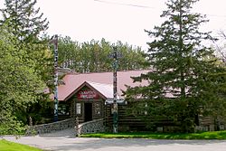
Curve Lake cultural centre
Curve Lake is the name of two Ojibwe Indian reserves 14 km north of Peterborough, Ontario. They serve as the landbase for the Curve Lake First Nation. The reserve occupies a peninsula located between Chemong Lake and Buckhorn Lake, surrounded by the township of Smith-Ennismore-Lakefield, as well as several neighbouring small islands in Buckhorn Lake.
Officially they are known as Curve Lake First Nation No. 35 and Curve Lake No. 35A. Curve Lake First Nation No. 35 has an area of 7.54 km², while Curve Lake No. 35A has an area of 2.02 km².
The Curve Lake First Nation occupies these two reserves and shares a third, the nearby Islands in the Trent Waters, with the Hiawatha First Nation and the Scugog First Nation. Curve Lake First Nation No. 35 occupies a peninsula between Buckhorn Lake, Lake Chemong, and Little Mud Lake. Curve Lake No. 35A is on Fox Island in Buckhorn Lake, and Islands in the Trent Waters is on islands in Buckhorn Lake, Pigeon Lake and Stony Lake.
External links
Categories: - First Nations reserves in Ontario
- Communities in Peterborough County, Ontario
- Anishinaabe reserves in Ontario
- Mississauga First Nation
- Eastern Ontario geography stubs
Wikimedia Foundation.
2010.
Look at other dictionaries:
Curve Lake First Nation — Curve Lake 35A reserve The Curve Lake First Nation is Mississauga Ojibway First Nation located in Peterborough County of Ontario. The Curve Lake First Nation occupies three reserves; Curve Lake First Nation 35 Reserve, Curve Lake 35A Reserve, and … Wikipedia
First Nations in Ontario — constitute many nations. Common First Nations ethnicities in the province include the Anishinaabe, Haudenosaunee, and the Cree.First Nations in Ontario* Aamjiwnaang First Nation * Alderville First Nation * Algonquins of Pikwàkanagàn First Nation… … Wikipedia
Chippewas of the Thames First Nation 42, Ontario — Chippewas of the Thames First Nation 42 Indian reserve … Wikipedia
Nipissing First Nation — The Nipissing First Nation consists of first nation (i.e. aboriginal) people of Ojibwa and Algonquin descent who have lived in the area of Lake Nipissing in the Canadian province of Ontario for about 9,400 years. Though in history known by many… … Wikipedia
Ardoch Algonquin First Nation — Die Ardoch oder Ardoch Algonquin First Nation sind eine der kanadischen First Nations in der Provinz Ontario. Sie werden allerdings von der Regierung nicht anerkannt. Sie stellen eine Anishnabek Gruppe dar, und leben im Entwässerungsgebiet von… … Deutsch Wikipedia
List of census subdivisions in Ontario — The following is a list of census subdivisions in the Canadian province of Ontario. NOTOC A B C D E F G H I J K L M N O P Q R S T U V W X Y Z*Key **C = City **R = First Nations Reserve **S E = Indian Settlement **T = Town **TP = Township **UNO =… … Wikipedia
Munsee-Delaware Nation 1, Ontario — Munsee Delaware Nation 1 Indian reserve … Wikipedia
Ojibways of the Pic River First Nation — (or Pic River for short) is an Ojibwa (Anishinaabe) First Nation band on the north shore of Lake Superior at the mouth of the Pic River. Pic River is not a signatory to the Robinson Superior treaty. The community is located on 316.6 ha Pic River… … Wikipedia
Chippewas of Georgina Island First Nation — Map of York Region showing Fox, Snake, and Georgina islands. Georgina Island, Lake Simcoe, Ontario The Chippewas of Georgina Island First Nation are an Ojibwa (or Anishinaabeg) pe … Wikipedia
Michipicoten First Nation — The Michipicoten First Nation is an Ojibwe First Nation in Northern Ontario, located near Wawa. Members of the community have resided at the mouth of the Michipicoten River since before the first arrival of European settlers to the area. The… … Wikipedia


 Curve Lake First Nation


