- Texas State Highway 495
Infobox TX State Highway
type=State
route=495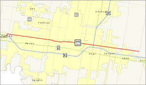
length_mi=17.736
length_ref=TxDOT|SH|495|accessdate=2008-03-08]
length_round=3
formed=2001
dir1=West
dir2=East
from=jct|state=TX|SH|364 at Mission
junction=jct|state=TX|US|281 in Pharr
to=jct|state=TX|FM|1423 near Alamo
previous_type=State
previous_route=365
next_type=State
next_route=550State Highway 495 or SH 495 is a
state highway in theU.S. state ofTexas that runs between Mission and Alamo in Deep South Texas. This route was designated in 2001, replacing Farm to Market Road 495. This route runs parallel to US 83 for its entire route. In McAllen, the route is also known as Pecan Blvd.Route description
SH 495 begins at SH 364 (La Homa Road) in Plainview near US 83. The highway heads east along Pecan Boulevard through Mission to an intersection with SH 107 (Conway Avenue). It has an intersection with FM 494 (Shary Road) before entering McAllen. In McAllen, the highway has several major intersections with
Farm to Market Road s to include FM 2220 (Ware Road), FM 1926 (23rd Street), FM 336 (10th Street) and FM 2061 (McColl Street). As it enters Pharr, the highway passes under the US 281 freeway with intersections with the freeway's frontage roads. The highway continues east into Alamo to an intersection with FM 907. The highway continues east to its eastern terminus at FM 1423 (Val Verde Road).cite map|publisher=Google Maps |title=Overview map of SH 495|accessdate=2008-03-08|url=http://maps.google.com/maps?f=d&hl=en&geocode=3869401213588291917,26.235070,-98.362000%3B10510296697558704197,26.216642,-98.217277%3B2670685758858562208,26.198235,-98.084534&saddr=Mile+1+Rd+N%2FVeterans+Blvd+%4026.235070,+-98.362000&daddr=W+Pecan+Blvd+%4026.216642,+-98.217277+to:N+Val+Verde+Rd+%4026.198235,+-98.084534&via=1&doflg=ptm&sll=26.216655,-98.22326&sspn=0.176795,0.376282&ie=UTF8&z=12]History
SH 495 began as FM 495 in 1945, running from northwest of McAllen east to Val Verde Rd., northeast of Alamo. In 1952, the route was extended west to SH 107 on the north side of Mission. In 1989, it was again extended west, this time to connect with U.S. Route 83 in Palmview. The route was then transferred to SH 495 in 2001, and was extended westward to Abram Road to make a new connection with US-83.
Junction list
References

Wikimedia Foundation. 2010.