- Mingachevir reservoir
-
Mingachevir Reservoir 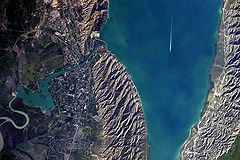
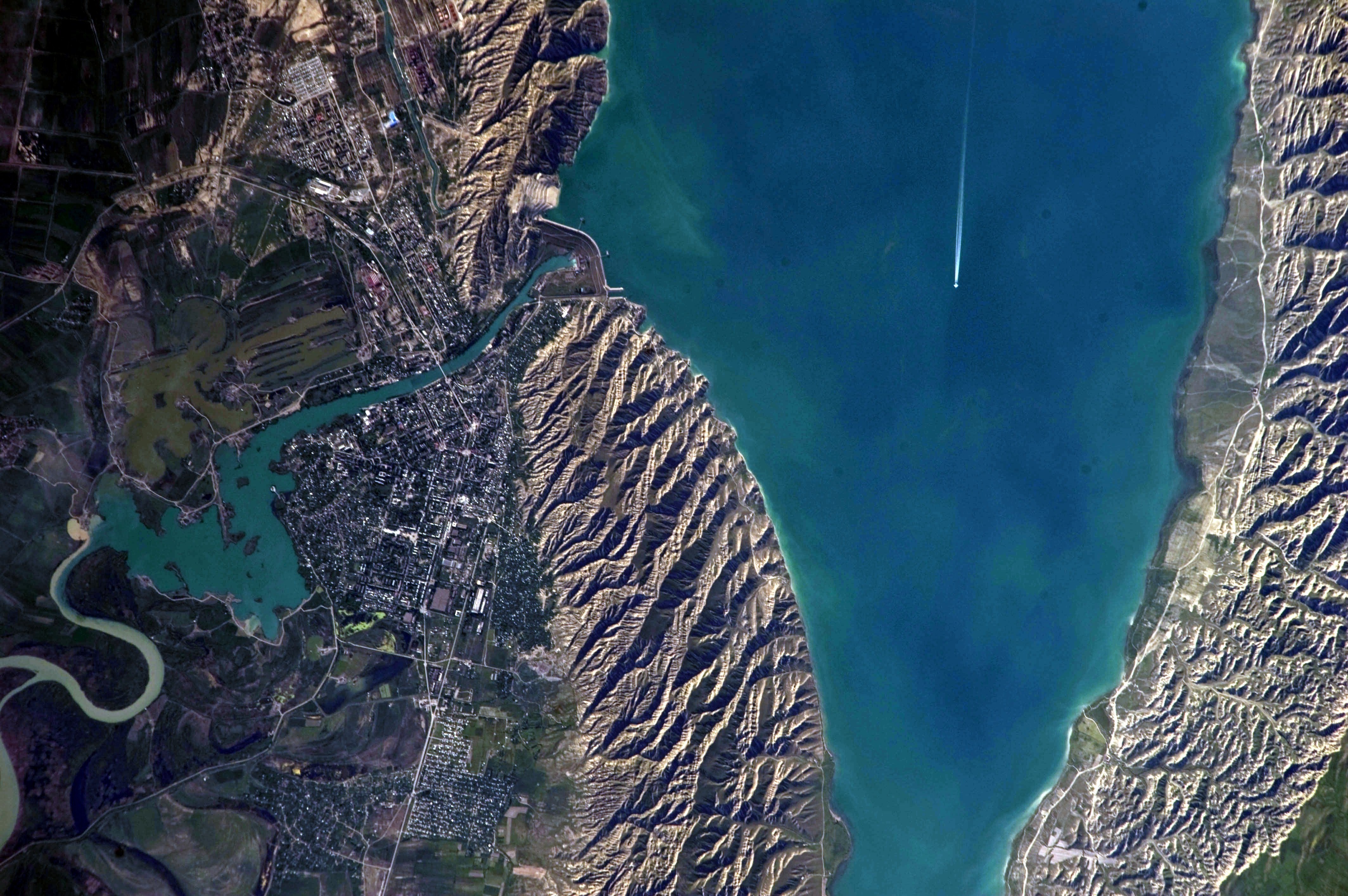
Mingachevir Reservoir from space Location Mingachevir Coordinates 40°47′20″N 47°01′40″E / 40.78889°N 47.02778°ECoordinates: 40°47′20″N 47°01′40″E / 40.78889°N 47.02778°E Lake type reservoir Primary inflows Kura River Primary outflows Kura River Basin countries Azerbaijan Max. length 70 km (43 mi) Max. width 18 km (11 mi) Surface area 605 km2 (234 sq mi) Average depth 26 m (85 ft) Max. depth 75 m (246 ft) Water volume 15730 mln m³ Shore length1 247 km (153 mi) 1 Shore length is not a well-defined measure. The Mingachevir reservoir (Azerbaijani: Mingəçevir su anbarı) is a large lake in northwestern Azerbaijan. It is the largest reservoir in the Caucasus.[1]
Overview
The reservoir was built on a section of Kura River flowing through Mount Bozdağ in 1953.[2] The filling capacity of the reservoir is 83 m (272 ft) whereas the volume is 15730 mln m³. It has been filled to its maximum levels in 1959, 1963, 1968, 1973, 1975, 1976, 1978, 1988 and 2010.[3] The length is 70 km (43 mi) and width is 18 m (59 ft). Maximum depth is 75 m (246 ft), average depth - 26 m (85 ft). The length along the shoreline is 247 km (153 mi), the overall area is 605 km2 (234 sq mi).[4][5] The largest hydroelectric power station of Azerbaijan is located on the reservoir. Mingechevir Hydro Power Plant has an installed electric capacity of 401.6 megawatts.[6] The length of the hydroelectric dam is 1,550 m (5,090 ft), its width is 16 m (52 ft) and height is 80 m (260 ft).[4]
The reservoir supplies water to Upper Karabakh and Upper Shirvan channels. It is also a source for fishing, water supplies and irrigation.
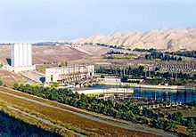 Mingachevir Hydroelectro station.
See also
- Rivers and lakes in Azerbaijan
- Shamkir reservoir
References
- ^ The Caucasus: an introduction Frederik Coene, p. 14, ISBN 0-415-48660-2
- ^ Ministry of Ecology. Reservoirs
- ^ Mingəçevir Su Anbarında su maksimal səviyyəyə çatıb Retrieved on 23 October 2010
- ^ a b AZƏRBAYCAN RESPUBLİKASI MELİORASİYA VƏ SU TƏSƏRRÜFATI AÇIQ SƏHMDAR CƏMİYYƏTİ: SU ANBARLARI
- ^ Water resources in Azerbaijan
- ^ Mingechevir HydroElectric Power Plant Retrieved on 23 October 2010
 Water bodies of Azerbaijan
Major rivers Major lakes Major reservoirs Mingechevir • Shamkir • Agstafa • Varvara • Araz • Jeyranbatan • Sarsang • Khanbulan • Vileshchay • YenikendCategories:- Lakes of Azerbaijan
- Hydroelectric power stations built in the Soviet Union

Wikimedia Foundation. 2010.