- Coquille River
-
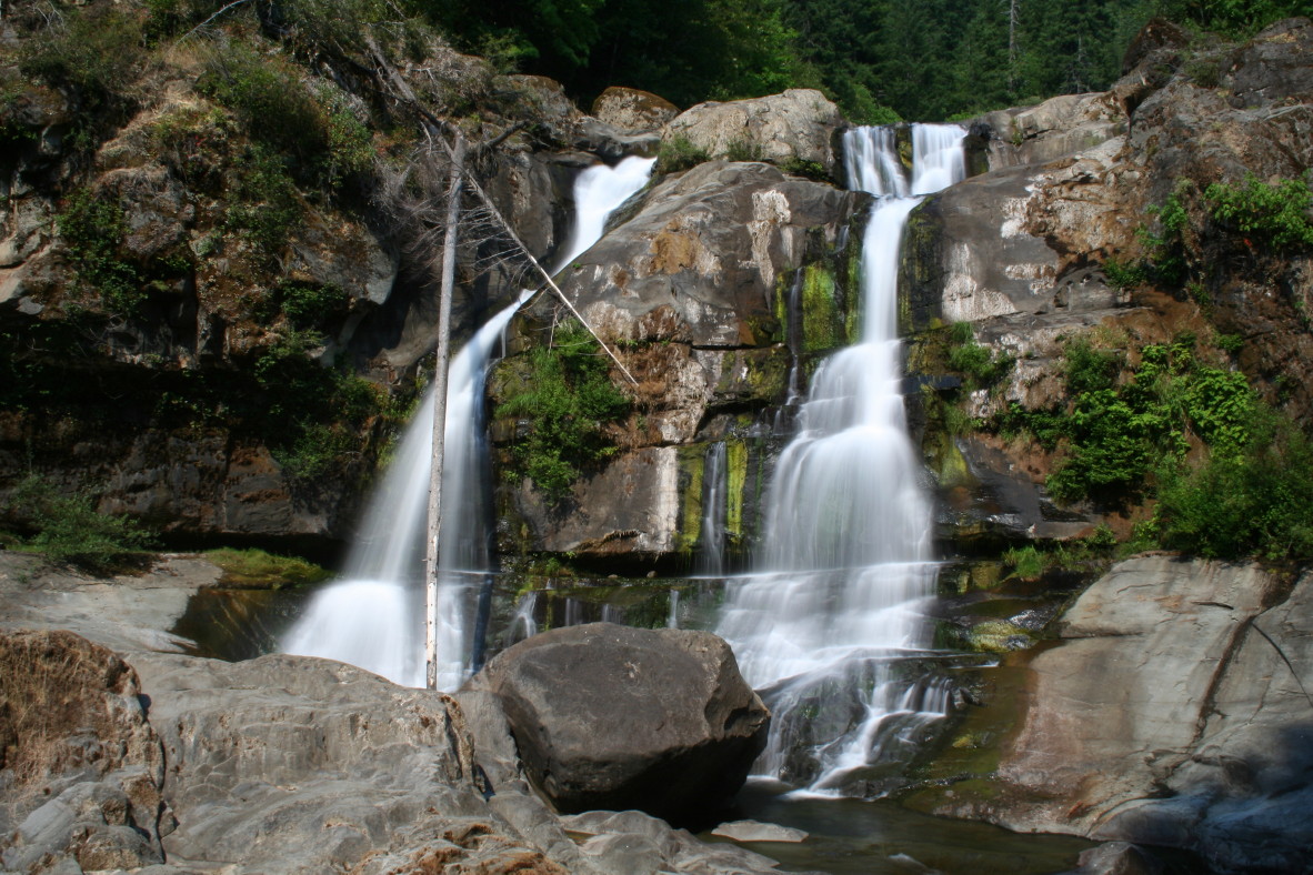
Coquille River  Coquille River Falls on the South Fork Coquille River
Country United States State Oregon County Coos Source Southern Oregon Coast Range - location Myrtle Point - elevation 17 ft (5 m) [1] - coordinates 43°04′49″N 124°08′28″W / 43.08028°N 124.14111°W [2] Mouth Pacific Ocean - location Bandon, Oregon - elevation 0 ft (0 m) [2] - coordinates 43°07′25″N 124°25′48″W / 43.12361°N 124.43°W [2] Length 36.3 mi (58 km) [3] Basin 1,059 sq mi (2,743 km2) [3] 
 Location of the mouth of the Coquille River in Oregon
The Coquille River is a stream 36.3 miles (58.4 km) long, in southwestern Oregon in the United States. It drains a mountainous area of 1,059 square miles (2,740 km2) of the Southern Oregon Coast Range into the Pacific Ocean. Its watershed is located between that of the Coos River to the north and the Rogue River to the south.[3][4]
Contents
Geography
The river, formed by the confluence of its north and south forks, begins at Myrtle Point. The North Fork Coquille River, 53.3 miles (85.8 km) long), rises in northern Coos County and flows southwest. The East Fork, 33.8 miles (54.4 km) long, rises in eastern Coos County, and flows generally west to join the North Fork.[3][4]
The South Fork, 62.8 miles (101.1 km) long, rises in southern Coos County, north of the Wild Rogue Wilderness Area, and flows generally north. It receives the Middle Fork, 40.3 miles (64.9 km) long, then joins the North Fork from the south at Myrtle Point. The combined river meanders generally west, past Coquille. It enters the Pacific at Bandon, about 20 miles (32 km) north of Cape Blanco.[3][4]
Tidal effect
The Coquille River is a tidal-effect river. During high tides at sea, the water at the mouth of the river acts like a dam, impeding the flow of the stream. Actually, more water always flows out into the ocean than enters with the tide. However, logs or sticks or leaves on the surface actually float up the river at certain times of day. There is a time lag between the high tide at sea and the effect pushing upstream. This varies according to the number of miles from the ocean. The tidal-effect is observed as far as Myrtle Point, some 28 to 30 miles upriver. The head of tide is 41 miles upriver from the mouth at Bandon. But some salt water does enter across the bar. The salt water intrusion was once minor. Today, however, sometimes traces of salinity appear only a few miles below the town of Coquille. This phenomenon affects industry along the river, as mills and other sites need fresh water intakes on the river in order not to rust or damage equipment or affect production processes.
On its main forks, the Coquille is also an alluvial river valley, meaning it was once a drowned river valley—a lake, or perhaps a much wider river, with a sandy bottom. The soil in the valley is very fertile. However, the rise and fall of the water level, and flooding in winter, prevent ordinary types of farming. A lush grass grows in the valley lowlands which can survive either drought or inundation. Tide-gates along the river can bring in water when needed. On this sweeping stand of grass, in summer many cattle find pasture.
History
In its natural state, the Coquille River meandered widely at its mouth. Owing to storms, tides, or other conditions, the river could empty into the sea as far north as a beach now called Whiskey Run, or as far south as a rock formation called Table Rock—an overall distance of several miles. It is said that when early sailing vessels tried to cross the dangerous bar to return to the port at Bandon, the main channel might have moved, or shoaled in, at the very place the ships had crossed safely on the outgoing journey.
Captain Judah Parker, a sea captain, built a jetty of bunches of cedar branches wrapped in burlap, sunken into the mud. Rocks were added. In the late 1890s, the government built jetties to force the channel to stay put. Huge boulders for the South Jetty, at Bandon, came from the blasting of a nearby mound of rock called Tupper Rock. The North Jetty is across the river, and clearly visible from the south jetty.
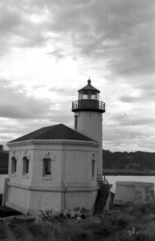
The Coquille River Lighthouse,[5] commissioned in 1896, guided mariners to find the dangerous bar at the mouth of the Coquille. The lighthouse was built on or near Rackleff Rock, a rocky obstacle in the channel. The rock became part of the bulwark of the North Jetty area. The lighthouse was decommissioned in 1939, following the last of improvements to the river channel.
The pioneer Hamblock and Bullards families had ranches in that region. But eventually their lands became part of the present Bullards Beach State Park. The old lighthouse building still stands. It is now a tourist attraction.
Literary setting
In his early science fiction book The Begum's Millions, Jules Verne depicted a fictional Utopian community named Ville-France being created in 1872 at the Coquille River's confluence with the Pacific, slightly south-west of the actual site of Bandon.
See also
- List of rivers of Oregon
- List of longest streams of Oregon
- Menai Strait#Tidal effects
- Firth (tidal effects)
- Steamboats of the Coquille River
References
- ^ Source elevation derived from Google Earth search using GNIS source coordinates.
- ^ a b c "Coquille River". Geographic Names Information System (GNIS). United States Geological Survey. November 28, 1980. http://geonames.usgs.gov/pls/gnispublic/f?p=gnispq:3:::NO::P3_FID:1161326. Retrieved December 3, 2009.
- ^ a b c d e "Introduction to the Coquille Watershed". Coquille Watershed Association. http://www.coquillewatershed.org/Coquille_Facts.html. Retrieved December 3, 2009.
- ^ a b c DeLorme Mapping. Oregon Atlas and Gazetteer (Map) (2008 ed.). ISBN 978-0-89933-347-2.
- ^ http://www.lighthousefriends.com/light.asp?ID=127 lighthousefriends.com
External links
Categories:- Rivers of Oregon
- Landforms of Coos County, Oregon

Wikimedia Foundation. 2010.