- Georgia State Route 113
Infobox road
state=GA
type=
route=113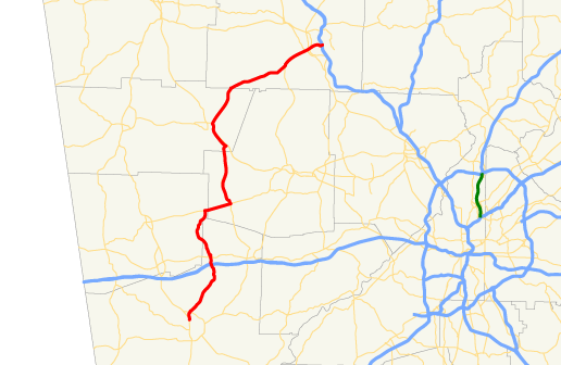
length_mi=38.93
length_ref= [http://www.dot.state.ga.us/DOT/plan-prog/transportation_data/400reports/2002/dpp444_2002.pdf]
length_round=2
established=
direction_a=South
direction_b=North
starting_terminus=
junction=
ending_terminus=
previous_route=112
next_route=114Description
State Route 113 begins at U.S. 27/S.R. 1 in Carrollton. The route runs north, intersects
Interstate 20 , then passes through the town of Temple. In extreme eastern Haralson County, the route begins a concurrency with S.R. 120 running east, then overlaps S.R. 101 northward. North of Yorkville, S.R. 101/S.R. 113 also overlap U.S. 278/S.R. 6 to Rockmart. The route departs Rockmart to the northeast. After crossing theEtowah River , the route passes through downtown Cartersville as Main Street, before reaching its northern terminus atInterstate 75 east of Cartersville.Future Emerson/Cartersville Bypass
Within the next few years, a new road in between Cartersville and Emerson will be constructed bypassing both towns. The road uses the existing Old Alabama Road and Red Top Mountain Roads, and a newly created section in between the two as well as a new section west of SR 61. This section will become SR 113 once completed (date is unknown).
Wikimedia Foundation. 2010.