Georgia State Route 13 — Infobox road state=GA type= route=13 alternate name=Buford Highway length mi=50 length ref= [http://www.dot.state.ga.us/DOT/plan prog/transportation data/400reports/2002/dpp444 2002.pdf] length round=0 established= direction a=South direction… … Wikipedia
Georgia State Route 17 — Infobox road state=GA type= route=17 length mi=300 length ref= [http://www.dot.state.ga.us/DOT/plan prog/transportation data/400reports/2002/dpp444 2002.pdf] length round=0 established= direction a=South direction b=North starting terminus=… … Wikipedia
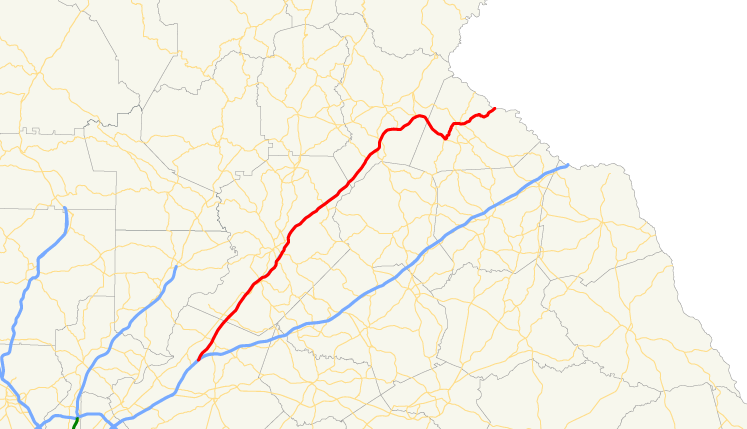
Georgia State Route 366 — Infobox road state=GA type= route=366 length mi=10 length round=0 length ref= [http://www.geocities.com/garoadwarrior76/garoutelog361 380.html Accessed February 2, 2007.] established=1967 deleted=1990 direction a=South direction b=North starting… … Wikipedia
Georgia State Route 384 — Infobox road state=GA type= route=384 alternate name= Duncan Bridge Road length mi=15.60 [http://www.dot.state.ga.us/DOT/plan prog/transportation data/400reports/2002/dpp444 2002.pdf] length km=25.11 direction a=North starting terminus= junction … Wikipedia
Georgia State Route 385 — Infobox road state=GA type= route=385 alternate name= Historic U.S. 441 length mi=4.60 [http://www.dot.state.ga.us/DOT/plan prog/transportation data/400reports/2002/dpp444 2002.pdf] length km=7.40 direction a=North starting terminus= junction=… … Wikipedia
Liste der State-, U.S.- und Interstate-Highways in Georgia — Dies ist eine Aufstellung von State Routes, U.S. Highways und Interstates im US Bundesstaat Georgia, nach Nummern. Inhaltsverzeichnis 1 State Routes 1.1 Gegenwärtige Strecken 1.2 Außer Dienst gestellte Strecken … Deutsch Wikipedia
Baldwin, Georgia — Infobox Settlement official name = Baldwin, Georgia other name = native name = nickname = settlement type = City motto = imagesize = image caption = flag size = image seal size = image shield = shield size = image blank emblem = blank emblem type … Wikipedia
Habersham County, Georgia — Seal … Wikipedia
McIntosh County, Georgia — Location in the state of Georgia … Wikipedia
Liste der State-, U.S.- und Interstate-Highways in Maryland — Dies ist eine Aufstellung von State Routes, U.S. Highways und Interstates im US Bundesstaat Maryland, nach Nummern. Inhaltsverzeichnis 1 State Routes 2 Interstates 2.1 Zubringer und Umgehungen … Deutsch Wikipedia