- Ozark Trail (auto trail)
-
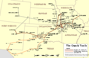 A map showing routes adopted (red) and others promoted (white) by the Ozark Trails Association.
The Ozark Trail was a network of locally maintained roads and highways organized by the Ozark Trails Association that predated the United States federal highway system. The roads ran from St. Louis, Missouri, to El Paso, Texas, and Santa Fe, New Mexico, over a series of routes.[1] These roads were maintained by both private citizens and local communities. In one case, however, the US government was directly involved; it built the Ozark Trail Bridge in 1925 over the South Canadian River between Newcastle, Oklahoma, and Oklahoma City, as the first federal highway project built in Oklahoma.[citation needed]
These roads comprised the major highway system in the region until U.S. Highway 66 was built in the 1920s. In Oklahoma, portions of the section-line roads between Anadarko and Hobart are still referred to as "The Old Ozark Trail."
Obelisk markers are located at several places on the trail, including Farwell, Dimmitt, Wellington, and Tulia, Texas.
Contemporary online references of the term "Ozark Trail" for this road include:
- A blog from a nearby farm.
- A point on the trail near the confluence of 35°N 99°W / 35°N 99°W.
- A cemetery list that mentions the Ozark Trail as a landmark.
References
- http://www.nps.gov/history/rt66/HistSig/New%20Mexico.htm
- http://www.drivetheost.com/ozarktrails.html
- http://www.drivetheost.com/williamhopeharve.html
- http://www.drivetheost.com/ozarkmap.html
- http://www.drivetheost.com/otmarkergallery.html
- http://www.okladot.state.ok.us/hqdiv/p-r-div/spansoftime/roadsystem.htm
Categories:- The Ozarks
- Auto trails in the United States
- U.S. Route 66

Wikimedia Foundation. 2010.