- Central Bohemian Region
-
Central Bohemia
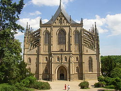
Střední ČechySaint Barbara Cathedral in Kutná Hora 
Flag
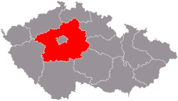
Coat of armsCountry Czech Republic Government – Governor David Rath (ČSSD) Area – Total 11,014 km2 (4,252.5 sq mi) Highest elevation 865 m (2,838 ft) Population (03/2011) – Total 1,284,629 – Density 116.6/km2 (302.1/sq mi) Time zone CET (UTC+1) – Summer (DST) CEST (UTC+2) ISO 3166-2 CZ-ST Licence plate S NUTS code CZ02 GDP per capita (PPS) € 17,200[1] Website http://www.kr-stredocesky.cz/ Central Bohemian Region (Czech: Středočeský kraj) is an administrative unit (Czech: kraj) of the Czech Republic, located in the central part of its historical region of Bohemia. Its administrative center is placed in the Czech capital Prague (Czech: Praha), which lies in the center of the region. The city is not, however, a part of it and creates a region of its own.
Contents
Districts
Benešov · Beroun · Kladno · Kolín · Kutná Hora · Mělník · Mladá Boleslav · Nymburk · Prague-East (Praha-východ) · Prague-West (Praha-západ) · Příbram · Rakovník
Cities and towns
- Beroun
- Benešov
- Brandýs nad Labem-Stará Boleslav
- Čáslav
- Dobřichovice
- Dobříš
- Kladno
- Kolín
- Kostelec nad Černými lesy
- Kralupy nad Vltavou
- Kutná Hora
- Mělník
- Mladá Boleslav
- Mnichovice (Prague-East District)
- Nymburk
- Poděbrady
- Příbram
- Rakovník
- Říčany
- Slaný
- Vlašim
Castles
- Karlštejn Castle
- Kokořín Castle
- Konopiště
- Křivoklát Castle
- Lány
References
External links
Regions of the Czech Republic 
Central Bohemia · Hradec Králové · Karlovy Vary · Liberec · Moravia-Silesia · Olomouc · Pardubice · Plzeň · Prague · South Bohemia · South Moravia · Ústí nad Labem · Vysočina · Zlín

Coordinates: 49°59′54″N 14°32′50″E / 49.99833°N 14.54722°E

This Central Bohemian Region location article is a stub. You can help Wikipedia by expanding it.


