- Bray Daly Station
-
Bray Daly 
Bré Uí Dhálaigh 
Bray Daly railway station Location Place Bray Local authority County Wicklow Operations Station code 140 Platforms in use 3 (2 in regular use) History July 10, 1854 Station opens as Bray July 14, 1924 Renamed Bri Chualann (Bray) c.1930 Renamed Bray April 10, 1966 Renamed Bray Daly Station closes for goods traffic Iarnród Éireann - Ireland railway stations A B C D E F G H I J K L M N O P Q R S T U V W X Y Z Bray Daly Station (Stáisiún Bhré / Uí Dhálaigh in Irish) is a railway station serving Bray in County Wicklow, Ireland.
Contents
Routes
DART
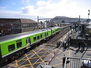
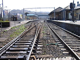
From the inception of the Dublin Area Rapid Transit (DART) service until its extension to Greystones in 2000, Bray Daly station served as the terminus for the service, and thus a large number of tracks are present just south of the station for inactive trains at the end of the line. Although some DARTs now continue southwards to Greystones, the majority of southbound services still terminate in Bray. Northbound DART services towards Howth and Malahide usually begin their routes in Bray, however since the aforementioned expansion to Greystones, some DART services originate there instead. From Bray heading southbound the line becomes single track.
Other services
Bray is also on the Dublin-Rosslare and Dundalk-Dublin-Arklow routes, and all passenger services on these routes serve the station. Often, these services will run non-stop between Bray and Dublin Connolly railway station, however only freight and maintenance trains pass through Bray without stopping. Between the 1984 inauguration of DART and November 1990, a diesel shuttle train (initially a 201 class or 121 class locomotive with former AEC railcars converted to push–pull stock, later an 80 class train leased from Northern Ireland Railways) operated between Bray and Greystones, connecting with DART services.[1] A similar service using a steam railmotor had operated briefly between 1906 and 1908.[2]
Station Building
The station houses a bar, two shops , a ticket office and unheated public toilets. A staff room is also present for drivers at the end of their route. Disabled access to platform two on the east side of the station was formerly through a separate gate on that side, however lifts are now provided on the footbridge.
The redevelopment which saw the installation of these lifts was a part of Iarnród Éireann's Dart Upgrade project, which sought to improve stations and facilities on the DART line. In addition to the lifts, the distinctive pyramid-style glass roof over platform two was also renovated, as was the main station building.
The station was opened on 10 July 1854.[3]
It was given the name Daly on 10 April 1966, 50 years after the Easter Rising when Córas Iompair Éireann renamed 15 of their major stations after Republican leaders. It is named in honour of Edward Daly, a leader in the 1916 Easter Rising.
Platforms
The station has two main platforms; platform one on the west side of the station near the main entrance, and platform two over the footbridge on the east side of the station. Although platform one is generally used for northbound services and platform two for southbound services and terminating trains, the roles are frequently reversed so as to accommodate as many services as possible. Platform three, the platform formerly used for the Greystones diesel shuttle, is now very seldom used as it has no northbound capacity (its line ends directly south of the station building), however it is often used for cleaning trains and occasionally for DART services to and from Greystones.
Picture Series
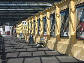
One of the more distinctive elements of Bray Daly Station is the series of paintings on platform two on the east side of the station. Beginning with a painting of the station's opening ceremony in 1852, the series runs along the length of Platform 2, documenting both Irish history and Irish railway history right up to the present day. Various forms of carriages, locomotives and characters can be seen in the pictures, including British soldiers in 1916, James Joyce in the 1940s, and a hippy couple in the 1960s. Many of these panels were in need of repair as lime was seeping through the plaster. In 2008 the original artist began a Mosaic replacement programme for the Mural.
Road transport services
Directly outside the station is a series of bus stops, at which Dublin Bus routes 45A, 45, 84, 145, 184 and 185 stop. The station is also served by Finnegan Bray local bus services . These busses all serve local routes, and connect Bray, by road with Dublin city, Dun Laoighre, Enniskerrry and Newtownmountkennedy. One Finnegan route, route 111 connects Bray with the Luas green line at Sandyford. There is a busy taxi rank outside the station. There is also a large car park adjacent to the station, and a pickup lane for collecting passengers by car.A tiny Chinatown adjoins the Station in Albert Walk with 2 restaurants and 2 groceries and other services.
Routes
Preceding station  Iarnród Éireann
Following station Dún Laoghaire
MallinIntercity
Dublin-RosslareGreystones Commuter
South Eastern CommuterShankill DART
Trans-DublinGreystones  Luas
LuasFrom 2015 Ravenswell Green Line Terminus Disused railways Shankill Dublin and South Eastern Railway
Dublin-RosslareBray Cove Halt External links
References
- ^ Whistler, A.J. (January 1995). "Greystones Shuttle". Journal of the Irish Railway Record Society 19 (127): 54–67.
- ^ Collins, Michael (June 2008). "Irish steam rail-motors and railcars". Journal of the Irish Railway Record Society 23 (166): 272–91.
- ^ "Wellingtonbridge station". Railscot - Irish Railways. http://www.railscot.co.uk/Ireland/Irish_railways.pdf. Retrieved 2008-04-22.
Categories:- Iarnród Éireann stations in County Wicklow
- Railway stations in County Wicklow
- Railway stations opened in 1854
- Bray, County Wicklow
Wikimedia Foundation. 2010.


