- Bernese Alps
Geobox|Range
name=Bernese Alps
other_name= _fr. Alpes bernoises
other_name1= _de. Berner Alpen
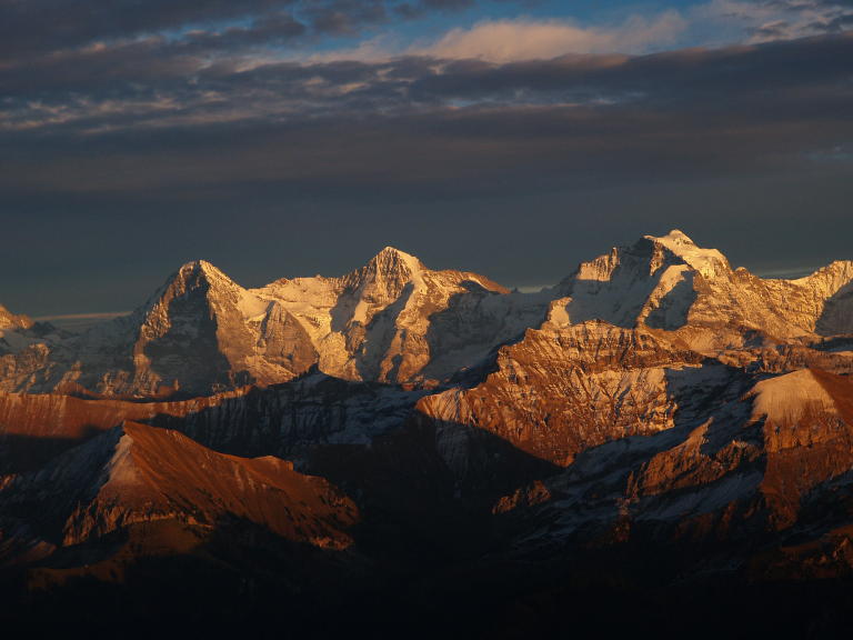
image_caption=The Eiger, Monch and Jungfrau
country=Switzerland
region_type=Cantons
region=Berne| region1=Vaud| region2=Fribourg
region3=Valais| region4=Lucerne| region5=Uri
region6=Nidwalden
parent=Alps
border=Chablais Alps | border1=Pennine Alps| border2=Lepontine Alps| border3=Urner Alps
length_imperial=| length_orientation=
width_imperial= | width_orientation=
geology= | period= | orogeny=
highest=Finsteraarhorn
highest_elevation=4274
highest_lat_d=46|highest_lat_m=32|highest_lat_s=19|highest_lat_NS=N
highest_long_d=8|highest_long_m=07|highest_long_s=38|highest_long_EW=E
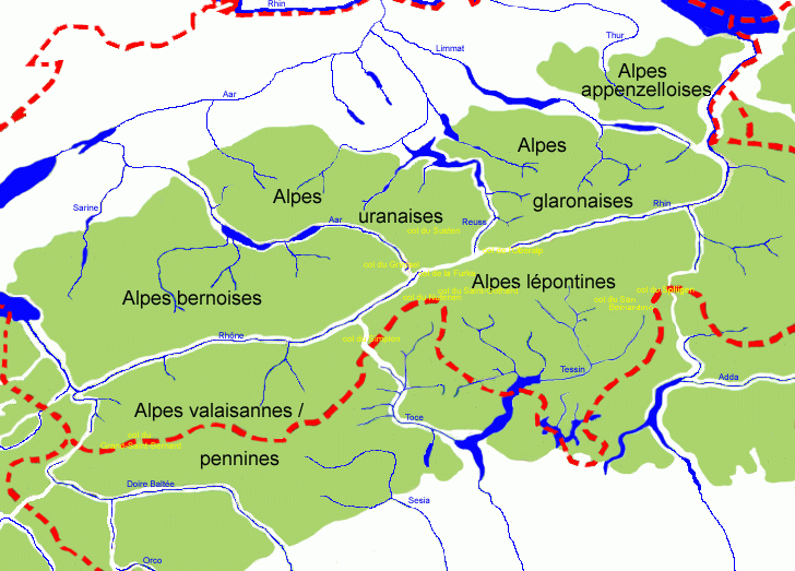
map_caption=Central AlpsThe Bernese Alps are a group of
mountain range s in the western part of theAlps , inSwitzerland . Although the name suggests they are in theBernese Oberland region of thecanton of Bern , portions of the Bernese Alps are located in the adjacent cantons ofVaud , Fribourg,Valais , Lucerne, Uri, andNidwalden .The Rhône valley separates them from the
Chablais Alps in the west and from thePennine Alps in the south; the upper Rhône valley separate them from theLepontine Alps in the south-east; theGrimsel Pass and theAar valley separates them from theUrner Alps in the east; their northern edge is not so well defined, describing a line roughly fromLake Geneva toLake Lucerne .The Bernese Alps are drained by the river
Aar and its tributarySaane in the north, the Rhône in the south and the Reuss in the east.List of peaks
The chief peaks of the Bernese Alps are:
Name Elevation Finsteraarhorn 4274 m 14,026 ft Aletschhorn 4182 m 13,721 ft Jungfrau 4166 m 13,669 ft Mönch 4105 m 13,468 ft Schreckhorn 4080 m 13,386 ft Grosses Fiescherhorn 4049 m 13,285 ft Grünhorn 4043 m 13,264 ft Lauteraarhorn 4042 m 13,261 ft Gletscherhorn 3983 m 13,067 ft Eiger 3970 m 13,025 ft Ebnefluh 3962 m 12,999 ft Bietschhorn 3934 m 12,907 ft Gross Wannenhorn 3905 m 12,812 ft Nesthorn 3820 m 12,533 ft Breithorn (Lauterbrunnen) 3779 m 12,399 ft Wetterhorn 3708 m 12,166 ft Balmhorn 3698 m 12,133 ft Silberhorn 3695 m 12,122 ft Blüemlisalphorn 3671 m 12,044 ft Doldenhorn 3647 m 11,966 ft Altels 3636 m 11,930 ft Tschingelhorn 3562 m 11,686 ft Gspaltenhorn 3442 m 11,293 ft Gross Hühnerstock 3348 m 10,985 ft Ewigschneehorn 3331 m 10,929 ft Ritzlihorn 3282 m 10,768 ft Wildhorn 3248 m 10,656 ft Diablerets 3246 m 10,650 ft Wildstrubel 3243 m 10,640 ft Wellhorn 3196 m 10,486 ft Mättenberg 3107 m 10,194 ft Löffelhorn 3098 m 10,165 ft Grand Muveran 3061 m 10,043 ft Sparrhorn 3026 m 9928 ft Torrenthorn 3003 m 9853 ft Dent de Morcles 2980 m 9777 ft Schilthorn 2973 m 9754 ft Eggishorn 2934 m 9626 ft Uri-Rotstock 2932 m 9620 ft Schwarzhorn 2930 m 9613 ft Gross Sidelhorn 2881 m 9452 ft Albristhorn 2764 m 9069 ft Faulhorn 2683 m 8803 ft Gummfluh 2461 m 8074 ft Sulegg 2412 m 7914 ft Vanil Noir 2395 m 7858 ft Niesen 2366 m 7763 ft Brienzer Rothorn 2351 m 7714 ft Tour d'Aï 2334 m 7658 ft Hohgant 2202 m 7225 ft Stockhorn 2192 m 7192 ft Kaiseregg 2189 m 7182 ft Le Chamossaire 2116 m 6943 ft Rochers de Naye 1740 m 5710 ft Le Moléson 2006 m 6582 ft Dent de Jaman 1879 m 6165 ft List of passes
The chief passes of the Bernese Alps are:
Mountain pass location type elevation Lauitor Lauterbrunnen to theEggishorn snow 3700 m 12,140 ft Mönchjoch Grindelwald to theEggishorn snow 3560 m 11,680 ft Jungfraujoch Wengernalp to theEggishorn snow 3470 m 11,385 ft Strahlegg Pass Grindelwald to theGrimsel Pass snow 3351 m 10,995 ft Grünhornlücke Great Aletsch Glacier to theFiescher Glacier snow 3305 m 10,844 ft Oberaarjoch Grimsel to theEggishorn snow 3233 m 10,607 ft Gauli Pass Grimsel toMeiringen snow 3206 m 10,519 ft Petersgrat Lauterbrunnen to theLötschental snow 3205 m 10,516 ft Lötschenlücke Lötschental to theEggishorn snow 3204 m 10,512 ft Lauteraarsattel Grindelwald to theGrimsel snow 3156 m 10,355 ft Beichgrat Lötschental to theBelalp snow 3136 m 10,289 ft Lammernjoch Lenk to theGemmi snow 3132 m 10,276 ft Triftlimmi Rhone Glacier to theGadmental snow 3109 m 10,200 ft Sustenlimmi Stein Alp to Göschenen snow 3103 m 10,181 ft Gamchilucke Kiental toLauterbrunnen snow 2833 m 9295 ft Tschiugel Pass Lauterbrunnen toKandersteg snow 2824 m 9265 ft Hohtürli Pass Kandersteg to theKiental foot path 2707 m 8882 ft Lötschen Pass Kandersteg to theLötschental snow 2695 m 8842 ft Sefinenfurgge Lauterbrunnen to theKiental foot path 2616 m 8583 ft Wendenjoch Engelberg to theGadmental snow 2604 m 8544 ft Furtwangsattel Guttannen to theGadmental foot path 2558 m 8393 ft Furka Pass Rhône Glacier toAndermatt road 2436 m 7992 ft Rawil Pass Sion to Lenk im Simmental bridle path 2415 m 7924 ft Gemmi Pass Kandersteg toLeukerbad bridle path 2329 m 7641 ft Surenen Pass Engelberg to Altdorffoot path 2305 m 7563 ft Susten Pass Meiringen toWassen road 2262 m 7422 ft Sanetsch Pass Sion to Saanen bridle path 2234 m 7331 ft Joch Pass Meiringen toEngelberg bridle path 2215 m 7267 ft Grimsel Pass Meiringen to theRhone Glacier road 2164 m 7100 ft Kleine Scheidegg Grindelwald toLauterbrunnen path, railway 2064 m 6772 ft Col de Cheville Sion to Bex bridle path 2049 m 6723 ft Grosse Scheidegg Grindelwald toMeiringen bridle path 1967 m 6454 ft Col de Jaman Montreux toMontbovon mule path
railway tunnel1516 m 4974 ft Brünig Pass Meiringen toLucerne road, railway 1035 m 3396 ft ee also
*
Swiss Alps External links
* [http://earthobservatory.nasa.gov/Newsroom/NewImages/images.php3?img_id=17485 Bernese Alps] at
NASA Earth Observatory References
*1911
Wikimedia Foundation. 2010.