- Deline, Northwest Territories
Infobox Settlement
name = Deline
native_name = Délįne
other_name = Location map polarx
CanadaGeo
caption =
lon_shift = 4.1
label= Délįne
label-size=70 | lat_skew=1.2
background = #DDDD22
position=top
lat = 65.186667
long = -123.421667
mark=Green_pog.svg
marksize=6
width=250
float=right
settlement_type = Settlement Corporation
motto =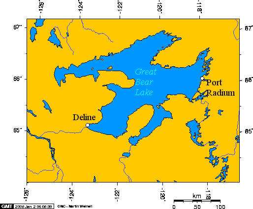
imagesize =
image_caption = Great Bear Lake, NWT, Canada
flag_size =
image_
seal_size =
image_shield =
shield_size =
subdivision_type =Country
subdivision_name =Canada
subdivision_type1 = Territory
subdivision_name1 =Northwest Territories
subdivision_type2 = Region
subdivision_name2 =Sahtu Region
subdivision_type3 =Constituency
subdivision_name3 = Sahtu
subdivision_type4 = Census division
subdivision_name4 =Inuvik Region, Northwest Territories
leader_title = Ehk'Wahtide
leader_name = Raymond Tutcho
leader_title1 = Senior Administrative Officer
leader_name1 = Ronald Mackeinzo
leader_title2 = MLA
leader_name2 = Norman Yakeleya
established_title = Charter Community
established_date = 1 April 1993
area_land_km2 = 79.33
elevation_m = 214
latd= 65.186667
longd= -123.421667
population_total = 525
population_density_km2 = 6.6
timezone = Mountain (MST)
utc_offset = -7
timezone_DST = MDT
utc_offset_DST = -6
postal_code_type =Canadian Postal code
postal_code = X0E 0G0
area_code = 867
blank_name =Telephone exchange
blank_info = 589
footnotes = Sources:Community Governance Data List [http://www.maca.gov.nt.ca/governments/printpage.asp?Other=FALSE Community Governance Data List] ] ,
2006 Canada Census,
Prince of Wales Northern Heritage Centre [http://www.pwnhc.ca/programs/downloads/OfficialCommunityNames.pdf Prince of Wales Northern Heritage Centre - official names] ] ,
Délįne profile at the Legislative Assembly [ [http://www.assembly.gov.nt.ca/_live/pages/wpPages/mapdeline.aspx Legislative Assembly of the Northwest Territories, Délįne profile] ]
Canada Flight Supplement [CFS]The Charter Community of Délįne is located in the
Sahtu Region of theNorthwest Territories ,Canada on the western shore ofGreat Bear Lake and is 544 km (338 mi) northwest ofYellowknife .The population as of the 2006 Census was 525, [http://www12.statcan.ca/english/census06/data/profiles/community/Details/Page.cfm?Lang=E&Geo1=CSD&Code1=6107003&Geo2=PR&Code2=61&Data=Count&SearchText=Deline&SearchType=Begins&SearchPR=01&B1=All&Custom= 2006 Census] ] mainly
Sahtu Dene people speaking North Slavey. [ [http://www12.statcan.ca/english/profil01/CP01/Details/Page.cfm?Lang=E&Geo1=CSD&Code1=6107003&Geo2=PR&Code2=61&Data=Count&SearchText=Colville%20Lake&SearchType=Begins&SearchPR=01&B1=All 2001 Census] ] Délįne means "where the waters flow", a reference to the headwaters of the Great Bear River, Sahtúdé.Pitchblende
The area became prominent when pitchblende was discovered at the
Eldorado Mine , some 250 km (155 mi) away, on the eastern shore, at Port Radium. DuringWorld War II , the Canadian government took over the mine and began to produceuranium for the then-secret Americannuclear bomb project. The village became a permanent settlement in 1952 with the building of a school.The Dene from Délįne, who were conscripted as ore carriers, were not informed about the risks of radioactivity or how to protect themselves. Most of those men who participated began to die of
cancer in the 1960s.According to oral history, while canoeing on Great Bear Lake in the early part of the 20th century, a Délįne elder reached a precipice where he had a vision of a great city burning, of people who comported First Nations features enduring great suffering. According to tradition, this precipice is where uranium was later discovered.
John Franklin
The community was formerly called "Fort Franklin" and was the site of
John Franklin 's winter site during his . The community changed to the current name on1 June ,1993 Land claims
Délįne is represented by the
Deline First Nation and belong to theSahtu Dene Council . [ [http://nwt-tno.inac-ainc.gc.ca/mpf/stakehld/delinefn_e.htm Indian and Northern Affairs Canada] ] Through the council they are in negotiations with theGovernment of Canada for aland claim s settlement.Polar bears
On
2 April 2008 threepolar bear s, a mother and two cubs, were seen in the community, which is convert|480|km|mi south of theArctic Ocean . The bears, which were harassing dogs, and posed a danger to local people were shot by a member of theRoyal Canadian Mounted Police due to the lack of wildlife officers with tranquillisers. A biologist with the Government of the NWT took samples from the bears, which aremarine mammal s and usually remain near the ocean. The biologist stated that the animals were starving and that they were unable to take fat samples and their muscles were starting to break down. A biologist with theUniversity of Alberta said that the unusual sighting was "...probably an indication of something changing broadly over an ecosystem,". [ [http://www.nnsl.com/members/newspapers/stories/apr7_08bear.html News/North online] and print edition] [ [http://www.cbc.ca/canada/north/story/2008/04/03/deline-bears.html Wandering polar bears a sign of climate change: expert] ]References
* John Price, "Our own atomic victims,"
Victoria Times-Colonist ee also
*
Déline Airport
*Déline Water Aerodrome External links
* [http://www.maca.gov.nt.ca/governments/communityresult.asp?ComCode=303 Municipal Affairs and Community Administration profile]
* [http://www.stats.gov.nt.ca/Infrastructure/Comm%20Sheets/Deline.html Deline at the GNWT]
* [http://www.deline.ca/ Welcome to Délįne]
* [http://www.antenna.nl/wise/uranium/uippra.html Village of Widows]
Wikimedia Foundation. 2010.